Ground PM2.5 concentration feature vector spatial filter value modeling method based on remote sensing data

A technology of PM2.5 and eigenvectors, applied in the field of spatial statistical analysis services, can solve the problems that the distribution of ground PM2.5 is affected by spatial factors, and the regression model cannot completely eliminate the spatial influence of PM2.5 concentration, etc., to improve accuracy, Effects of elimination of influences, modeling process and simplicity of model structure

Active Publication Date: 2018-07-03
WUHAN UNIV
View PDF7 Cites 20 Cited by
  • Summary
  • Abstract
  • Description
  • Claims
  • Application Information

AI Technical Summary

Problems solved by technology

[0027] In order to solve the problem that the distribution of ground PM2.5 is affected by spatial factors, and the traditional regression model cannot completely eliminate the spatial influence and accurately estimate the PM2.5 concentration, the present invention provides a ground PM2.5 concentration feature vector based on remote sensing data Spatial Filter Value Modeling Method

Method used


Image

  • Ground PM2.5 concentration feature vector spatial filter value modeling method based on remote sensing data
  • Ground PM2.5 concentration feature vector spatial filter value modeling method based on remote sensing data
  • Ground PM2.5 concentration feature vector spatial filter value modeling method based on remote sensing data

Examples


Embodiment

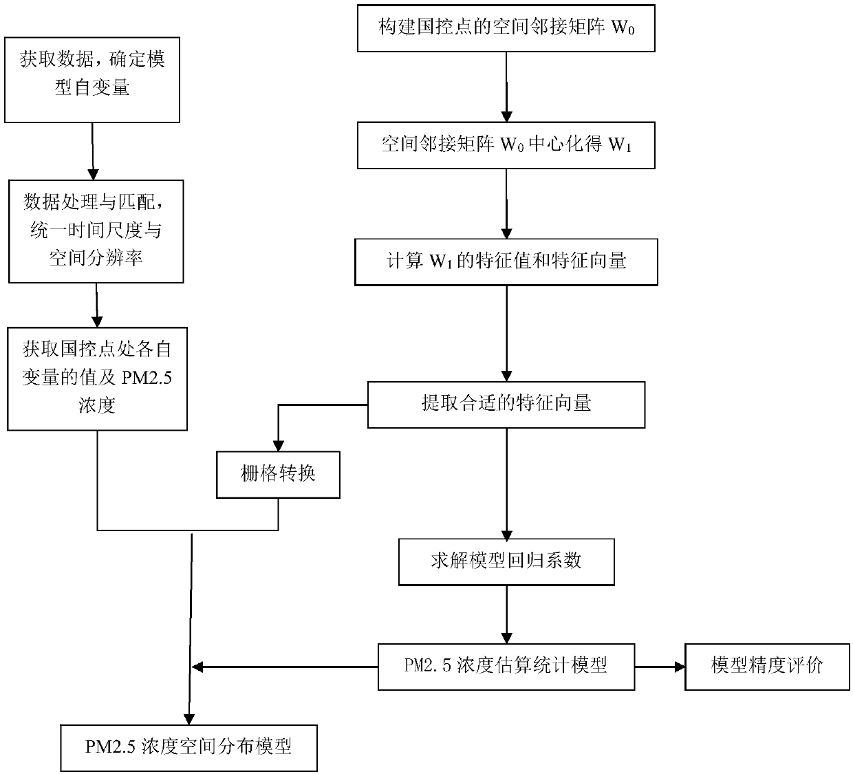
[0068] An embodiment employs the following subroutines:

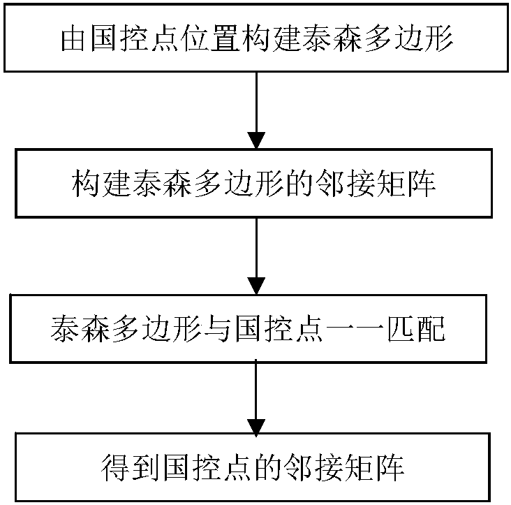
[0069] Step 3.1 Constructing Thiessen polygons: Example Constructing Thiessen polygons by national control points.

[0070] Since the national control point is a discretely distributed point element, the adjacency relationship of the point is not easy to determine. Therefore, we choose to construct Thiessen polygons first, and divide the study area into continuous non-overlapping surface elements. Each polygon contains a station, so that the adjacency of polygons A relationship is the adjacency relationship between its corresponding sites.

[0071] Step 3.2 Create a spatial adjacency matrix: Create a space adjacency matrix of the Thiessen polygon, which is the adjacency matrix of the national control point.

[0072] Then according to the Queen's adjacency rule, the binary adjacency matrix W is constructed from the adjacency relationship of the Thiessen polygon 0 , that is, polygons i and j are adjacent, then the eleme...


PUM


Abstract

The present invention provides a ground PM2.5 concentration feature vector spatial filter value modeling method based on remote sensing data. The method comprises: obtaining data, selecting a model variable, carrying out data processing and matching, constructing a spatial adjacency matrix from the location of the national control point of a study area, carrying out centralization, calculating thematrix eigenvalues and eigenvectors, and extracting the appropriate eigenvectors from the vector group as the spatial influence factor of the PM2.5 concentration; and obtaining an eigenvector spatialfilter regression model of the PM2.5 concentration, interpolating the extracted eigenvectors raster images with the same spatial resolution as the AOD, and bringing the raster images into the eigenvector spatial filter regression model for raster calculation to obtain the continuous spatial distribution model of the PM2.5 concentration in the study area. According to the method provided by the present invention, for the problem that the number of ground control points is small and the ground control points are unevenly distributed, the remote sensing data with high resolution and continuous distribution is selected to perform the inversion of the ground PM2.5 concentration for study on a wide range of PM2.5 spatiotemporal features.

Description

technical field [0001] The invention belongs to the technical field of spatial statistical analysis service application, and in particular relates to a modeling method of ground PM2.5 concentration feature vector spatial filtering value based on remote sensing data. Background technique [0002] PM2.5 has great harm to the air environment quality and human health. On the one hand, PM2.5 pollution will cause environmental problems such as corrosion and vegetation damage, and the scattering and extinction effect of fine particles will reduce the visibility of the atmosphere. On the other hand, due to the small size of PM2.5 (the diameter is about 1 / 30 of the average thickness of human hair), it can penetrate deep into the lungs of the human body through breathing, and infiltrate into the blood together with the toxic substances on the surface, causing adverse effects on human health. Moreover, it floats in the atmosphere for a long time and spreads far, and its harmful effect...

Claims


Application Information

Patent Timeline
Patent Type & Authority Applications(China)
IPC IPC(8): G06F17/50G06F17/18
CPCG06F17/18G06F30/20
Inventor 陈玉敏张静祎吴钱娇肖雨薇杨帆徐仁
Owner WUHAN UNIV
Why Eureka
Try Eureka