Construction site surveying method and system combining surface laser radar and oblique photography

A ground-based lidar and oblique photography technology, applied in radio wave measurement systems, re-radiation of electromagnetic waves, measurement devices, etc., can solve problems such as time-consuming and labor-intensive, safety of surveyors and hidden dangers in survey quality, etc., and achieve rich information and remarkable technology Benefits and social benefits, the effect of reducing field workload

Inactive Publication Date: 2018-08-07
CHINA RAILWAY SIYUAN SURVEY & DESIGN GRP
View PDF8 Cites 26 Cited by
  • Summary
  • Abstract
  • Description
  • Claims
  • Application Information

AI Technical Summary

Problems solved by technology

[0003] At present, site surveys are usually completed by manual on-site surveying and identification using GPS-RTK, total station and other technologies. Although the methods are...

Method used


Image

  • Construction site surveying method and system combining surface laser radar and oblique photography
  • Construction site surveying method and system combining surface laser radar and oblique photography
  • Construction site surveying method and system combining surface laser radar and oblique photography

Examples


specific Embodiment

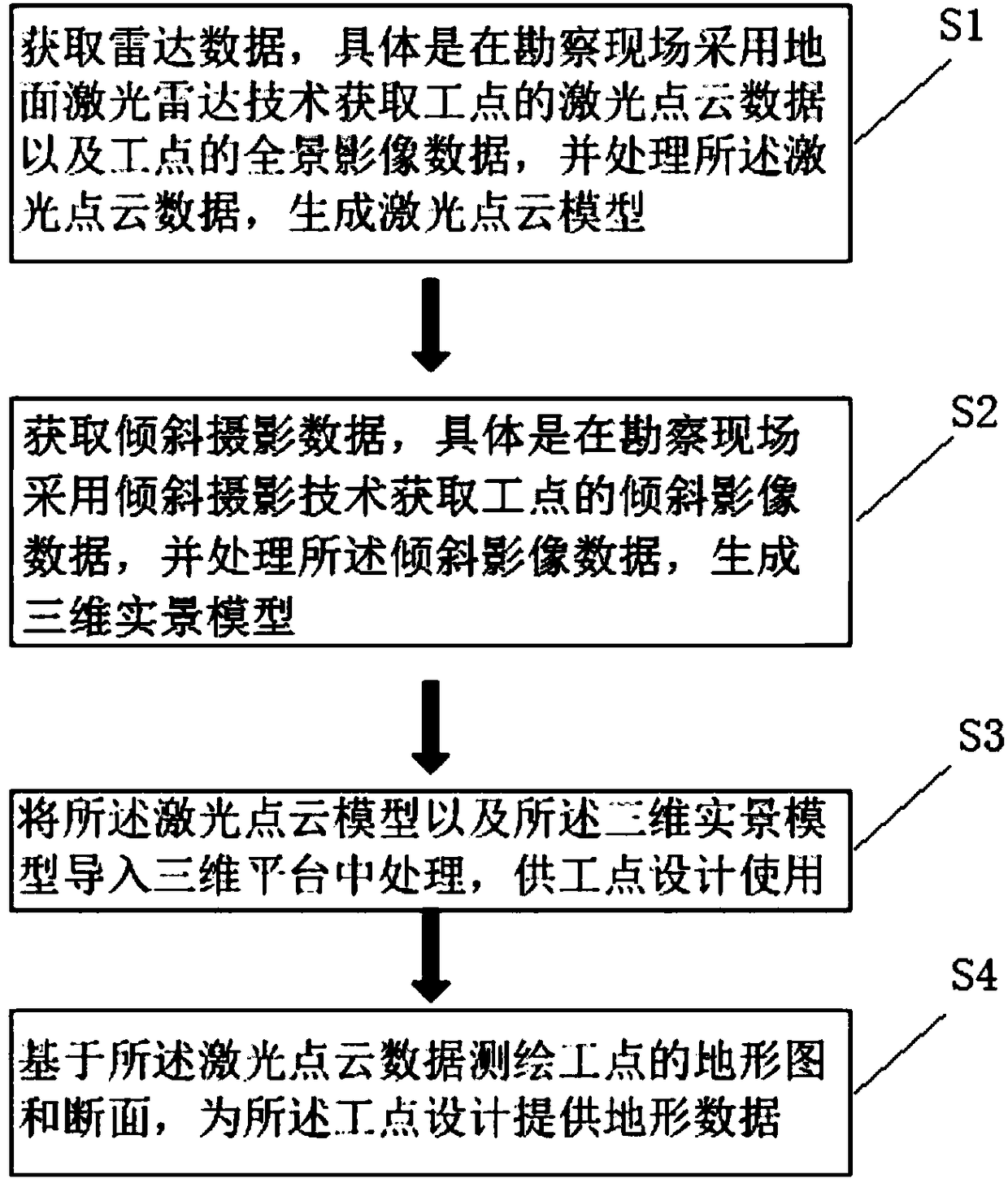
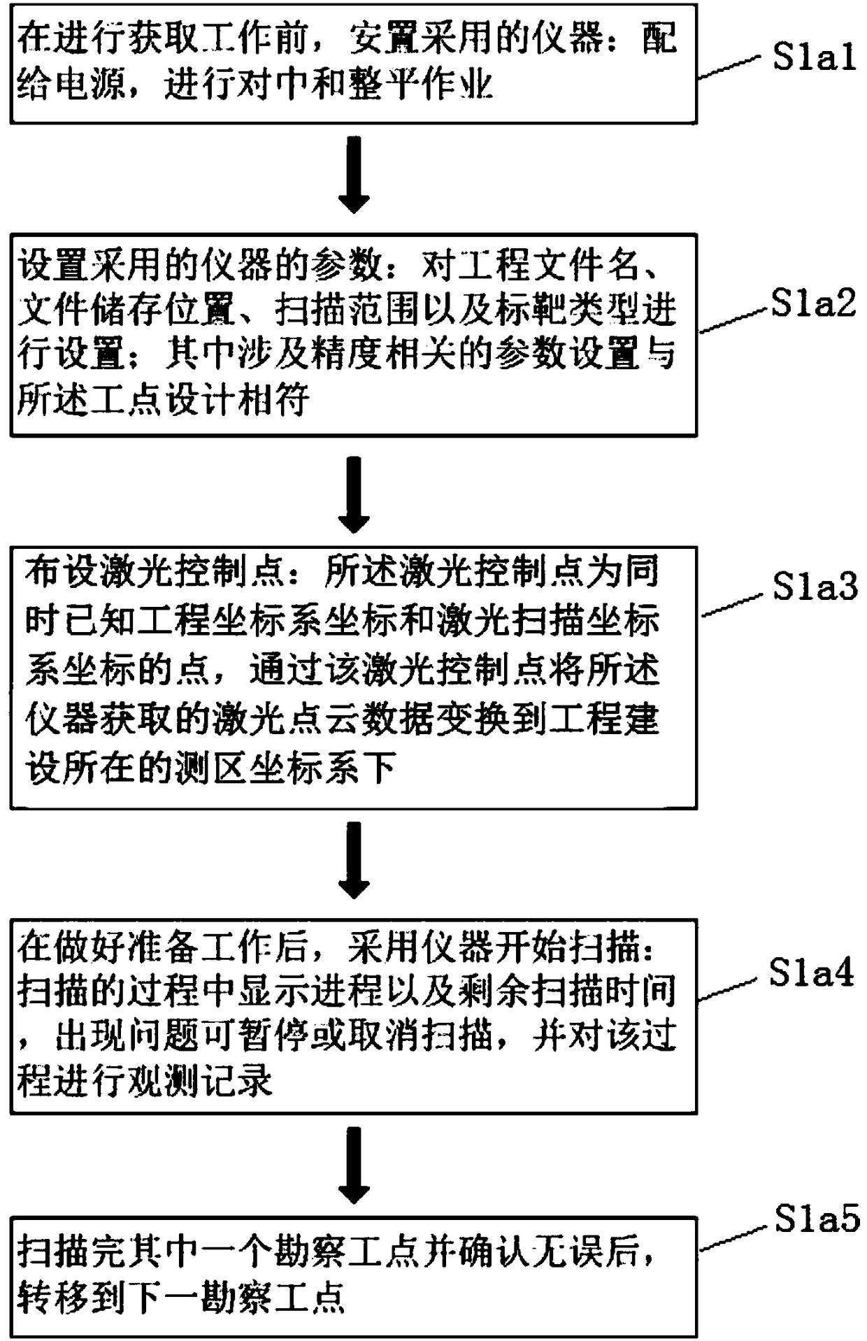
[0073] To optimize the above scheme, please refer to figure 2 In the above step S1, before proceeding with the acquisition work, some preparatory work is required, including instrumentation, personnel organization, transportation, logistics support, and measurement control point layout. For different brands of instrument models, the specific scanning operation method on a measuring station will be different. The basic steps of scanning on a measuring station are as follows:

[0074] S1a1, the instrument used for placement: supply power for alignment and leveling operations; S1a2, set the parameters of the instrument used: set the project file name, file storage location, scanning range, and target type; among them are related to accuracy The parameter settings are consistent with the design of the work point; S1a3, laser control points are arranged: the laser control points are points whose engineering coordinate system coordinates and laser scanning coordinate system coordinates...


PUM


Abstract

The invention relates to the field of construction site surveying and provides a construction site surveying method combining surface laser radar and oblique photography, comprising: S1, acquiring radar data; S2, acquiring oblique photography data; S3, introducing a laser point cloud model and a three-dimensional real scene model into a three-dimensional platform for processing, and allowing the processed information to be used in construction site design; S4, drawing a tomographic map and section of a construction site based on laser point cloud data to provide geographic data for working site design. A construction site surveying system combining surface laser radar and oblique photography is provided, comprising a surface laser scanner, a flight platform, a processing module and a camera mounted on the flight platform. The construction site surveying method and system combining surface laser radar and oblique photography have the advantages that the ground laser radar and oblique photography are combined, technical advantages are mutually complemented, manual measurement can be replaced, fine working site surveying can be achieved under high quality and high precision, field work is greatly decreased, surveying period is greatly shortened, and significant technical and social benefits are provided; rich information is acquired and is recorded via equipment, and data can be back-tracked at any time.

Description

Technical field [0001] The invention relates to the field of site surveys, in particular to a site survey method combining ground laser radar and oblique photography. Background technique [0002] In the engineering survey and design, in order to optimize the route plan, select the bridge type, locate the pier and abutment, arrange the geological drilling and design the tunnel entrance and exit, etc., it is necessary to carry out detailed survey work on certain work points. In the site survey, not only the topographic map and cross section of the site need to be surveyed and drawn with high precision, but also the topography, landform, lithology, etc. on the site must be manually interpreted to identify dangerous rocks and falling rocks. Therefore, to complete the site survey, not only quantitative measurement, but also qualitative interpretation. [0003] At present, site surveys are usually completed by manual field surveying and identification using technologies such as GPS-RTK...

Claims


Application Information

Patent Timeline
IPC IPC(8): G01C11/02G01S17/89
CPCG01C11/02G01S17/89
Inventor 李海亮冯光东熊国华曹成度汤建凤胡玉雷刘善勇朱雪峰胡晓斌刘冰洋
Owner CHINA RAILWAY SIYUAN SURVEY & DESIGN GRP
Why Eureka
Try Eureka