
Method for three-dimensionally positioning target cooperatively formed images of double-onboard SAR

A stereo positioning and target technology, applied in the direction of radio wave reflection/re-radiation, instruments, measuring devices, etc., can solve the problems of pixel position information, inaccessibility, etc., and achieve the effect of reducing the amount of calculation, effective detection and positioning

Active Publication Date: 2018-09-07
NANJING UNIV OF SCI & TECH
View PDF1 Cites 11 Cited by
  • Summary
  • Abstract
  • Description
  • Claims
  • Application Information

AI Technical Summary

Problems solved by technology

The existing bistatic airborne SAR technology commonly uses two radars as the transmitter and the receiver respectively. This method cannot obtain the actual position of the target by directly analyzing the equations from the pixel position information of the target in the SAR image. information

Method used


Image

  • Method for three-dimensionally positioning target cooperatively formed images of double-onboard SAR
  • Method for three-dimensionally positioning target cooperatively formed images of double-onboard SAR
  • Method for three-dimensionally positioning target cooperatively formed images of double-onboard SAR

Examples


Embodiment

[0072] In this embodiment, taking the positioning of a ship target in a cluttered ocean environment as an example, an exemplary implementation manner of the present invention is described in detail.

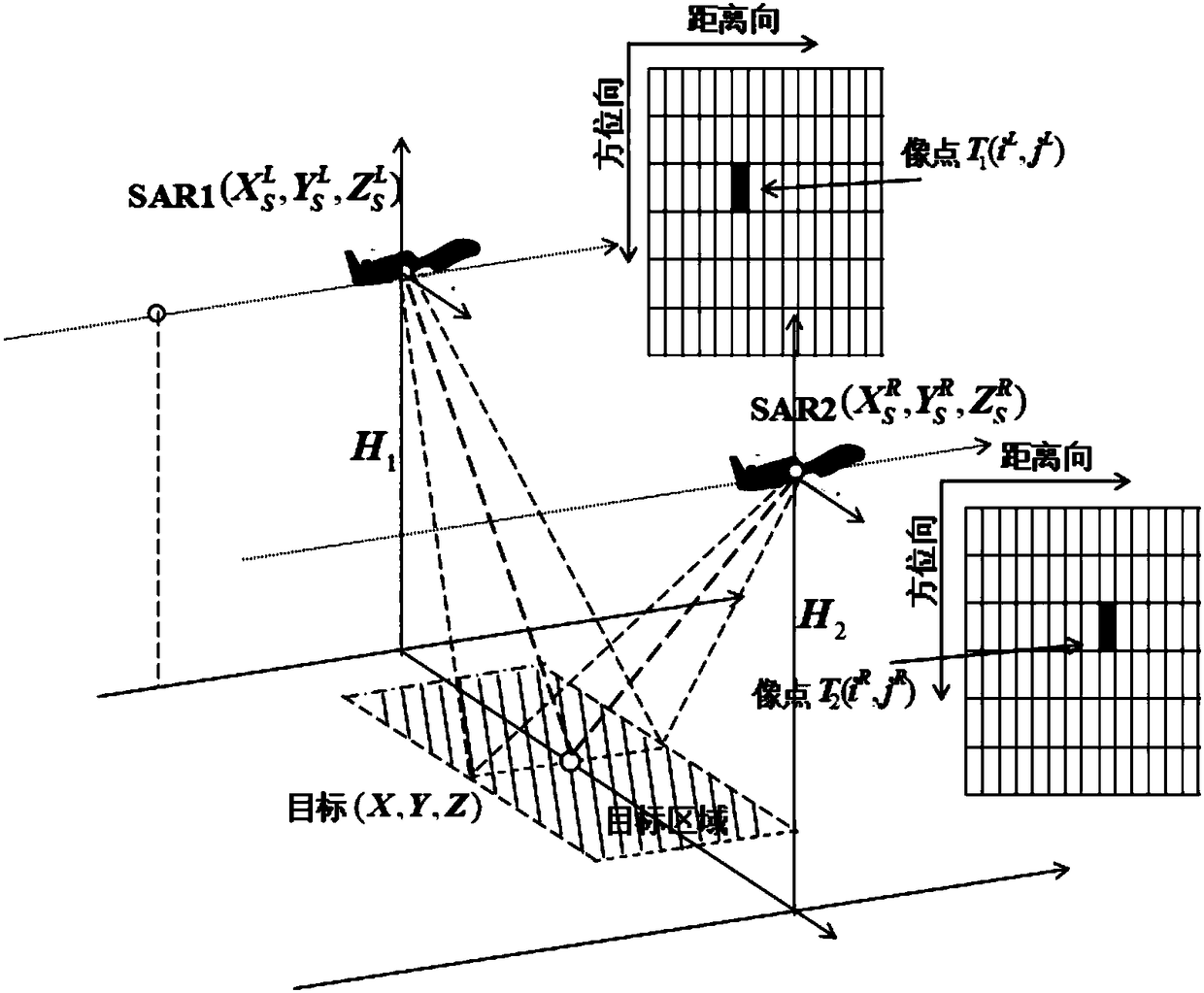
[0073] figure 1 A schematic diagram of the structure of a dual airborne SAR for target collaborative imaging stereotaxic positioning proposed by the present invention, mainly composed of two SAR radars with two fixed-wing unmanned aerial vehicles as platforms, and the two unmanned aerial vehicles are in the same direction in the target area Fly both sides while imaging the scan area.

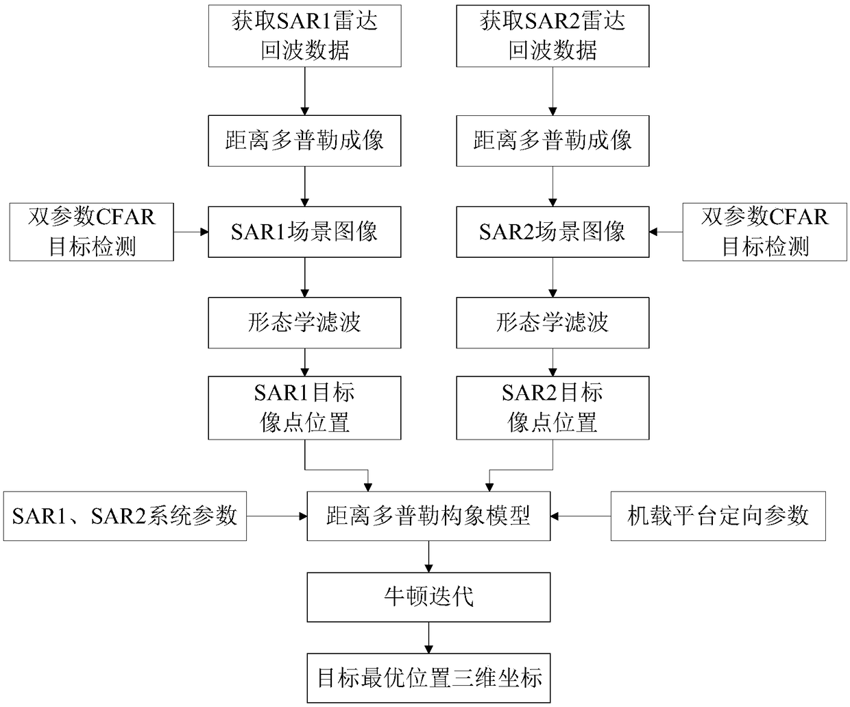
[0074] figure 2 The general flow chart of a kind of dual-airborne SAR that proposes for the present invention is to the stereotaxic positioning of target cooperative imaging, and concrete implementation steps are:

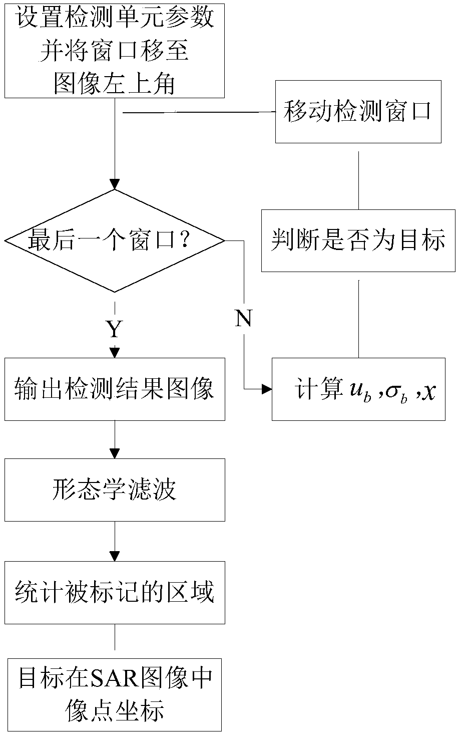
[0075] The first step is to use the range Doppler imaging algorithm to perform high-resolution imaging on the echo data of the sea surface scanning area received by the two airborne ...


PUM


Abstract

The invention discloses a method for three-dimensionally positioning target cooperatively formed images of a double-onboard SAR. The method comprises the steps that original echo data returned by a scene area is processed, and target scene imaging is completed through range direction compression, range migration correction and azimuth compression processing; double-parameter CFAR processing is conducted on two high-resolution SAR images respectively, target areas are detected out according to their geometrical characteristics, the geometric centers of the target areas are taken, and image point coordinates corresponding to target gray level areas are output; image point coordinate arrays are substituted into a positioning algorithm model, and coordinates of targets in a rectangular coordinate system are calculated by combining system parameters and directional parameters of two SAR through Newton iteration. Calculation can be directly performed after the image point coordinates of targets in images, accordingly the calculation quantity is greatly decreased, and real-timeliness is improved.

Description

technical field [0001] The invention belongs to the technical field of SAR positioning, and in particular relates to a method for stereo positioning of a target with cooperative imaging by dual airborne SARs. Background technique [0002] Synthetic Aperture Radar (SAR) has all-weather and all-weather earth observation capabilities. SAR has been widely used in ocean monitoring and has exerted huge social, economic and military benefits. Due to the different imaging bands, the SAR system can obtain ground object information different from that of the optical system. [0003] In general, military targets are composed of brighter scattering centers on radar images, so threshold segmentation technology can be used to achieve target detection. However, in the random and complex clutter background, the contrast between the background and the target changes in the image formed by SAR, and the image segmentation technology with a fixed threshold often produces more false targets. T...

Claims


Application Information

Patent Timeline
IPC IPC(8): G01S13/90
CPCG01S13/9005G01S13/9058
Inventor 肖泽龙张秋霞许建中吴礼张晋宇邵晓浪朱苇杭
Owner NANJING UNIV OF SCI & TECH
Learn More