Topography observation device based on mechanical fine tuning dual hosts

Technology of an observation device and a fine-tuning device

Active Publication Date: 2018-09-14
DALIAN UNIV OF TECH
View PDF6 Cites 8 Cited by
  • Summary
  • Abstract
  • Description
  • Claims
  • Application Information

AI Technical Summary

Problems solved by technology

[0003] But still there is following shortcoming in above-mentioned geomorphic instrument: 1 if after the geomorphic instrument main frame of test site is moved, the position and the angle of the laser in-line instrument in the main frame may change, that is, the contour and parallel laser planes sent by the geomorphic instrument main frame will occur. large error
No matter from which angle the laser plane emitted by a single host of the geomorphology instrument enters the gully, it may be disconnected, making it impossible to fully observe the landform of the concave gully

Method used


Image

  • Topography observation device based on mechanical fine tuning dual hosts
  • Topography observation device based on mechanical fine tuning dual hosts
  • Topography observation device based on mechanical fine tuning dual hosts

Examples


Embodiment Construction

[0027] The present invention will be further elaborated below in combination with specific embodiments and accompanying drawings.

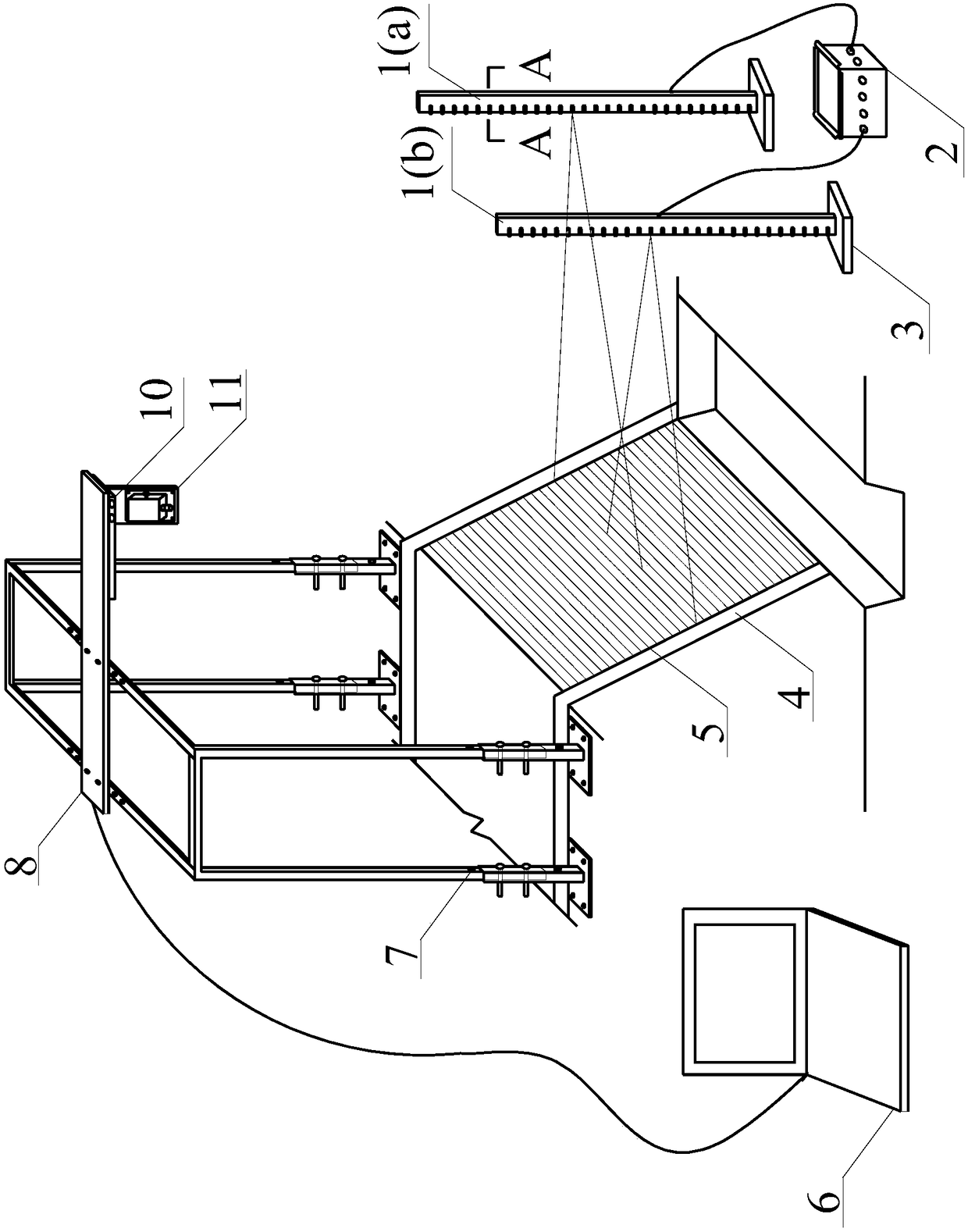
[0028] Taking the gravity erosion test of the Liudaogou small watershed in Shenmu County as an example, the specific implementation steps of a geomorphic observation device based on mechanical fine-tuning and dual hosts are explained:

[0029] Step 1: Mechanical fine-tuning stage of geomorphology instrument

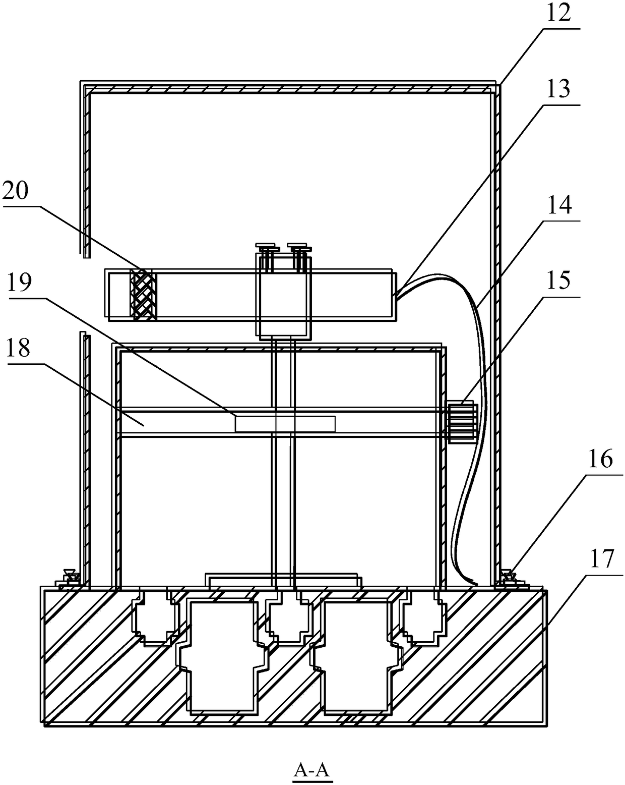
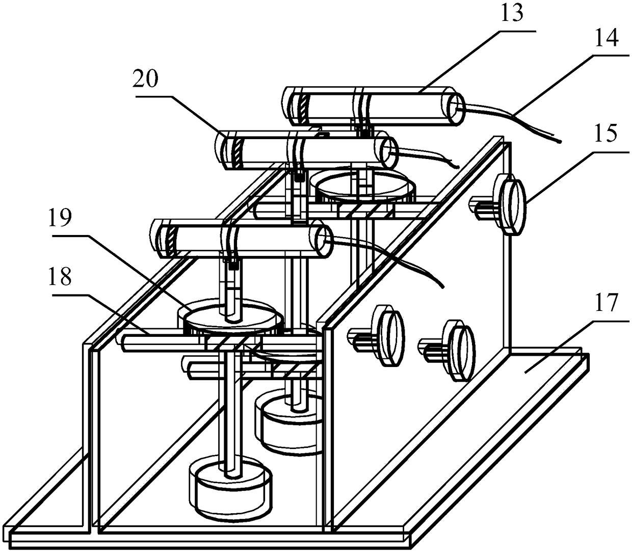
[0030]The support bar with rotating worm gear 19 is fixed on the main base plate 17, and the laser word instrument 13 is fixed on the top of the support bar with worm gear by bolts, and the worm screw 18 and the rotating worm gear 19 are hinged by threads; The worm handle knob 15 can make the laser diametric instrument 13 rotate around the support rod to realize the equidistant laser lines projected by the laser diametric instrument 13 on the plane to be measured, and the adjustment accuracy is 1mm. Rotating the laser head fine-tuning knob 2...


PUM


Abstract

The invention belongs to the technical field of water and soil conservation study devices, and relates to a dynamic observation device used for a slope topography evolution process. The two hosts emitparallel, equal-height and overlapping laser planes from different orientations, and the laser planes are projected onto the slope topography; an image collecting device shoots the slope topography which laser rays are projected onto at an angle perpendicular to the layer planes to form a video screenshot, the video screenshot is imported into a computer to form a three-dimensional stereogram, and then parameters such as the slope volume and the slope gradient are calculated. According to the device, by rotating rotary knobs of mechanical fine tuning devices in the topographic meter hosts, equal-interval parallel accurate adjustment of laser ray planes is achieved; according to the device, by observing a fixing bolt on a support and a worm handle rotary knob in a view screen box, moving and rotation of a camera used for image collection are controlled. The invention provides a novel topographic meter through which the spacing and the angle of a linear laser can be conveniently calibrated, and all the topographies including local deep grooves on an eroded slope can be accurately observed.

Description

technical field [0001] The invention belongs to the technical field of soil and water conservation research devices, and relates to a device for dynamic observation of slope landform evolution process. Background technique [0002] Due to the complexity of soil erosion phenomena, reliable methods are often sought to observe and analyze erosion landforms in order to obtain its occurrence mechanism. Looking at the observation methods of soil erosion at home and abroad, they can be summarized into two types: survey method after rain and dynamic observation method in rain. The post-rain survey method is a method of inferring the amount of water and soil loss by investigating the landform characteristics after rainfall. For example, Yang Jishan et al. Observation of Gravity Erosion in Suideqiaogou Small Watershed, Shaanxi Yang Jishan, Yao Wenyi, Wang Lingling. Research on Gravity Erosion Law and Mechanism of Loess Channel [J]. People Yellow River, 2014, 36:93-96. Recently, the ...

Claims


Application Information

Patent Timeline
Patent Type & Authority Applications(China)
IPC IPC(8): G01C11/00G01C11/04G01C9/00
CPCG01C9/00G01C11/00G01C11/04
Inventor 徐向舟郭文召张红武高璐赵兴阳
Owner DALIAN UNIV OF TECH
Why Eureka
Try Eureka