Multi-voyage map positioning and navigating method for suspended underwater autonomous vehicle

An autonomous vehicle and navigation method technology, applied in the field of multi-voyage map positioning and navigation, can solve the problems of limited effective distance of acoustic positioning, high cost of use, accumulation of dead reckoning errors, etc., to improve map accuracy, ensure positioning and navigation Accuracy, the effect of eliminating accumulated errors

Active Publication Date: 2018-09-28
HANGZHOU DIANZI UNIV
View PDF3 Cites 5 Cited by
  • Summary
  • Abstract
  • Description
  • Claims
  • Application Information

AI Technical Summary

Problems solved by technology

[0003] Traditional underwater positioning methods such as acoustic positioning and dead reckoning positioning in HAUV are expensive to use, and there are defects such as limited effective distance of acoustic positioning and dead reckoning has the problem of error accumulation.

Method used


Image

  • Multi-voyage map positioning and navigating method for suspended underwater autonomous vehicle
  • Multi-voyage map positioning and navigating method for suspended underwater autonomous vehicle
  • Multi-voyage map positioning and navigating method for suspended underwater autonomous vehicle

Examples


Embodiment Construction

[0040] The following will clearly and completely describe the technical solutions in the embodiments of the present invention with reference to the accompanying drawings in the embodiments of the present invention. Obviously, the described embodiments are some of the embodiments of the present invention, but not all of them. Based on the embodiments of the present invention, all other embodiments obtained by persons of ordinary skill in the art without making creative efforts belong to the protection scope of the present invention.

[0041] The invention discloses a multi-voyage map positioning and navigation method for a suspended underwater autonomous vehicle, and its specific embodiments are as follows.

[0042] (1) Establish a single-voyage image sequence database

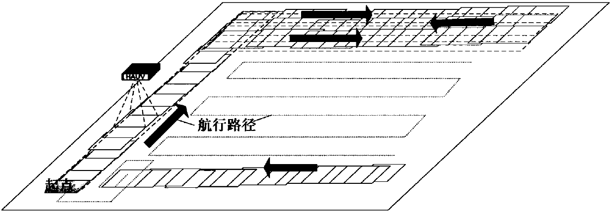
[0043] In one embodiment, HAUV is as figure 1 Carry out the cruise according to the preset navigation path shown, obtain the photos of the terrain in the underwater area, and after arriving at the navigation e...


PUM


Abstract

The invention discloses a multi-voyage map positioning and navigating method for a suspended underwater autonomous vehicle. The method comprises the following steps: S1, the vehicle cruises along a preset navigation path and acquires a photo sequence of underwater terrain; S2, image data processing and closed-loop detection are carried out; S3, feature matching is carried out to optimize the photosequence; S4, the significance of the photos is calculated; S5, the map accuracy is evaluated; S6, multi-voyage cruise is carried out to achieve same direction path map fusion and reverse path map optimization; S7, a map database is developed; and S8, significant regional path planning is carried out to achieve real-time positioning and navigation. The multi-voyage map positioning and navigatingmethod for the suspended underwater autonomous vehicle is a method for carrying out multi-voyage exploration on the same area for the HAUV application environment of a submarine base station to achieve map optimization in order to realize underwater precise positioning and navigation. The method can effectively solve the contradiction between the positioning accuracy and the operation efficiency and realize real-time high-precision navigation of the HAUV under water.

Description

technical field [0001] The invention belongs to the field of underwater vehicles, and in particular relates to a multi-voyage map positioning and navigation method for a suspended underwater autonomous vehicle. Background technique [0002] Hover Autonomous Underwater Vehicle (HAUV for short) is an autonomous underwater vehicle with powerful maneuverability. HAUV has multiple propellers, and has many advantages such as being able to suspend in the water layer, having strong vertical maneuverability, and being able to sail close to the seabed. [0003] The use of traditional underwater positioning methods such as acoustic positioning and dead reckoning positioning in HAUV is costly, and there are defects such as the limited effective distance of acoustic positioning, and dead reckoning has the problem of error accumulation. At this stage, the machine vision method based on seabed terrain is an effective means to solve the problem of HAUV underwater high-precision positioning...

Claims


Application Information

Patent Timeline
Patent Type & Authority Applications(China)
IPC IPC(8): G01C21/20
CPCG01C21/20G01C21/203
Inventor 史剑光彭时林于海滨刘敬彪孔庆鹏吕帅帅
Owner HANGZHOU DIANZI UNIV
Why Eureka
Try Eureka