Multi-rotor unmanned-aerial-vehicle aerial photography system for traffic design and implementation method thereof

A multi-rotor UAV and multi-rotor unmanned technology, applied in the field of multi-rotor UAV aerial photography system, can solve the problems of large manpower, material resources, poor timeliness, poor definition, and poor detail, and reduce manpower. The effect of material investment, fast data acquisition, and intuitive data visualization

Pending Publication Date: 2018-09-28
SHANDONG TRAFFIC PLANNING DESIGN INST
View PDF0 Cites 5 Cited by
  • Summary
  • Abstract
  • Description
  • Claims
  • Application Information

AI Technical Summary

Problems solved by technology

[0003] At present, preliminary surveys are carried out in each design stage of transportation infrastructure. Taking expressway design as an example, data such as 1:50,000 topographic maps, Google Maps, and Tiandi Maps are mostly used in the route selection stage. Although to a certain extent It can obtain the site conditions, but the 1:50,000 topographic map is poor in expressing the details of the site conditions, and cannot clearly and detailedly show the site conditions. Google Maps and Tiantu can provide orthophoto images of the engineering site, but these The image data is not updated in time, and the image resolution is low, which is poor in timeliness and clarity. At the same time, it is impossible to have a three-dimensional understanding of ground objects only through orthophoto images
[0004] In the preliminary design stage, the design route of the expressway has been determined, and the 1:2000 topographic map will be measured along the design route. According to the topographic map, the preliminary design of the road can be completed. The 1:2000 topographic map can be used to understand the site conditions to a certain extent. However, in order to ensure the mastery of the site conditions, the designers will check the site environment and terrain conditions along the design route, which will consume a lot of manpower and material resources
At the same time, it is impossible for all designers and industry experts to check the site, so that it cannot be guaranteed that every designer and expert can grasp the site situation. At the same time, simple photography and manual recording methods are often used for on-site recording methods. cannot cover all information

Method used


Image

  • Multi-rotor unmanned-aerial-vehicle aerial photography system for traffic design and implementation method thereof
  • Multi-rotor unmanned-aerial-vehicle aerial photography system for traffic design and implementation method thereof
  • Multi-rotor unmanned-aerial-vehicle aerial photography system for traffic design and implementation method thereof

Examples


Embodiment Construction

[0028] A multi-rotor UAV aerial photography system designed for traffic and its implementation method of the present invention will be described in detail below with reference to the accompanying drawings.

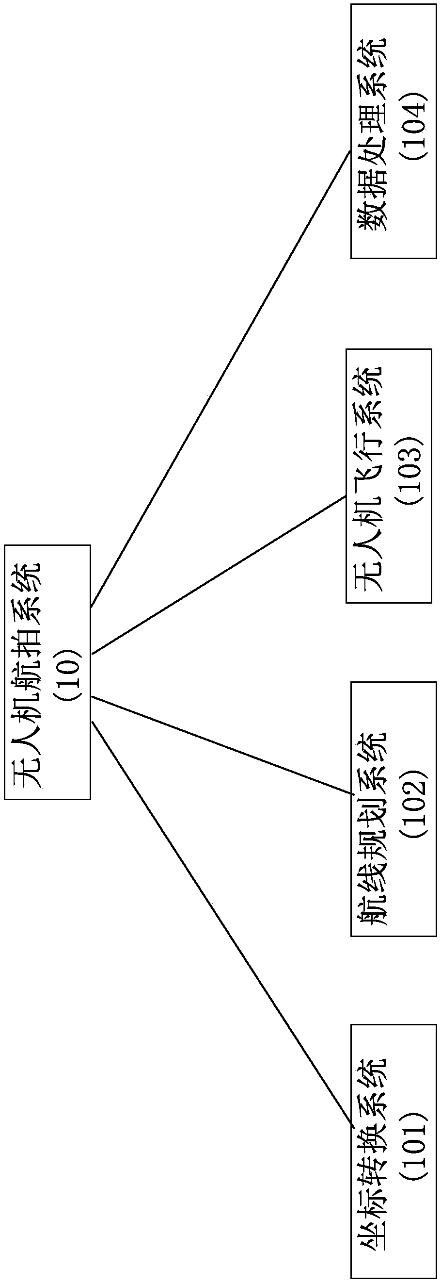
[0029] Such as figure 1 As shown, the multi-rotor drone aerial photography system 10 of the present invention includes a coordinate transformation system 101 , a route planning system 102 , a drone flight system 103 and a data processing system 104 .

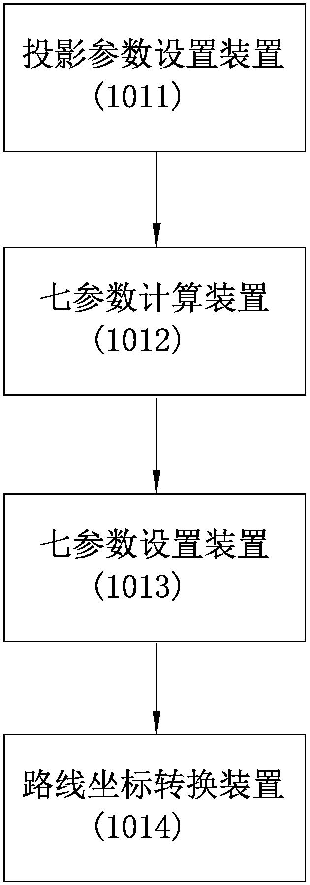
[0030] Such as figure 2 As shown, the coordinate conversion system 101 is used to realize the coordinate conversion between the UAV flight route and the design route, and is composed of a projection parameter setting device 1011, a seven-parameter calculation device 1012, a seven-parameter setting device 1013 and a route coordinate conversion device 1014 In the design of transportation infrastructure, taking expressway design as an example, the design route generally adopts the Xi'an 80 plane Cartesian coordinate system wi...


PUM


Abstract

The invention discloses a multi-rotor unmanned-aerial-vehicle aerial photography system for traffic design and an implementation method thereof. The multi-rotor unmanned-aerial-vehicle aerial photography system comprises a coordinate transformation system, an air route planning system, an unmanned-aerial-vehicle flight system and a data processing system. The coordinate transformation system comprises a projection parameter setting device, a seven-parameter calculation device, a seven-parameter setting device and a route coordinate transformation device. The air route planning system comprisesan air route segmenting device, a take-off point selection device and a flight parameter setting device. The unmanned-aerial-vehicle flight system comprises a ground control device, a multi-rotor unmanned aerial vehicle and a task loading device. A wireless data transmission link is arranged between the ground control device and the multi-rotor unmanned aerial vehicle. The multi-rotor unmanned aerial vehicle is connected with the task loading device through a holder camera interface. The multi-rotor unmanned-aerial-vehicle aerial photography system has the advantages of rapidness, convenienceand high timeliness in data acquisition, reduced manpower and material resource input, saved cost, direct data perception and the like. By the multi-rotor unmanned-aerial-vehicle aerial photography system and the implementation method thereof, the design of transportation infrastructures can be well carried out.

Description

technical field [0001] The invention relates to the technical field of unmanned aerial vehicle photography, in particular to a multi-rotor unmanned aerial vehicle aerial photography system designed for traffic and an implementation method thereof. Background technique [0002] Our country is a transportation powerhouse, and some transportation infrastructures are newly built or expanded every year, such as highways, municipal roads, ports, bridges and so on. The design stage is an important link in the construction of transportation infrastructure. Knowing the project site conditions can help designers better design project plans, and can compare and select plans to choose the best from multiple links such as economy, traffic volume, safety, and construction difficulty. route or best solution. [0003] At present, preliminary surveys are carried out in each design stage of transportation infrastructure. Taking expressway design as an example, data such as 1:50,000 topograph...

Claims


Application Information

Patent Timeline
IPC IPC(8): G05D1/10
CPCG05D1/101
Inventor 相诗尧徐润李振江张常勇赵杰
Owner SHANDONG TRAFFIC PLANNING DESIGN INST
Why Eureka
Try Eureka