Method for estimating nitrogen and phosphorus pollution in drainage basin based on spatial remote sensing technology

A remote sensing technology and watershed technology, applied in the field of accurate and efficient evaluation of non-point source nitrogen and phosphorus loss, can solve the problems of difficult operation and low simulation accuracy, and achieve the effects of improving accuracy, saving costs, improving efficiency and feasibility

Active Publication Date: 2018-10-12
BEIJING NORMAL UNIVERSITY
View PDF4 Cites 9 Cited by
  • Summary
  • Abstract
  • Description
  • Claims
  • Application Information

AI Technical Summary

Problems solved by technology

Restricted by topography, field conditions and workload at various points in the watershed, it is extremely difficult to respond to large-scale soil moisture through field experiments
The model

Method used


Image

  • Method for estimating nitrogen and phosphorus pollution in drainage basin based on spatial remote sensing technology
  • Method for estimating nitrogen and phosphorus pollution in drainage basin based on spatial remote sensing technology
  • Method for estimating nitrogen and phosphorus pollution in drainage basin based on spatial remote sensing technology

Examples


Embodiment Construction

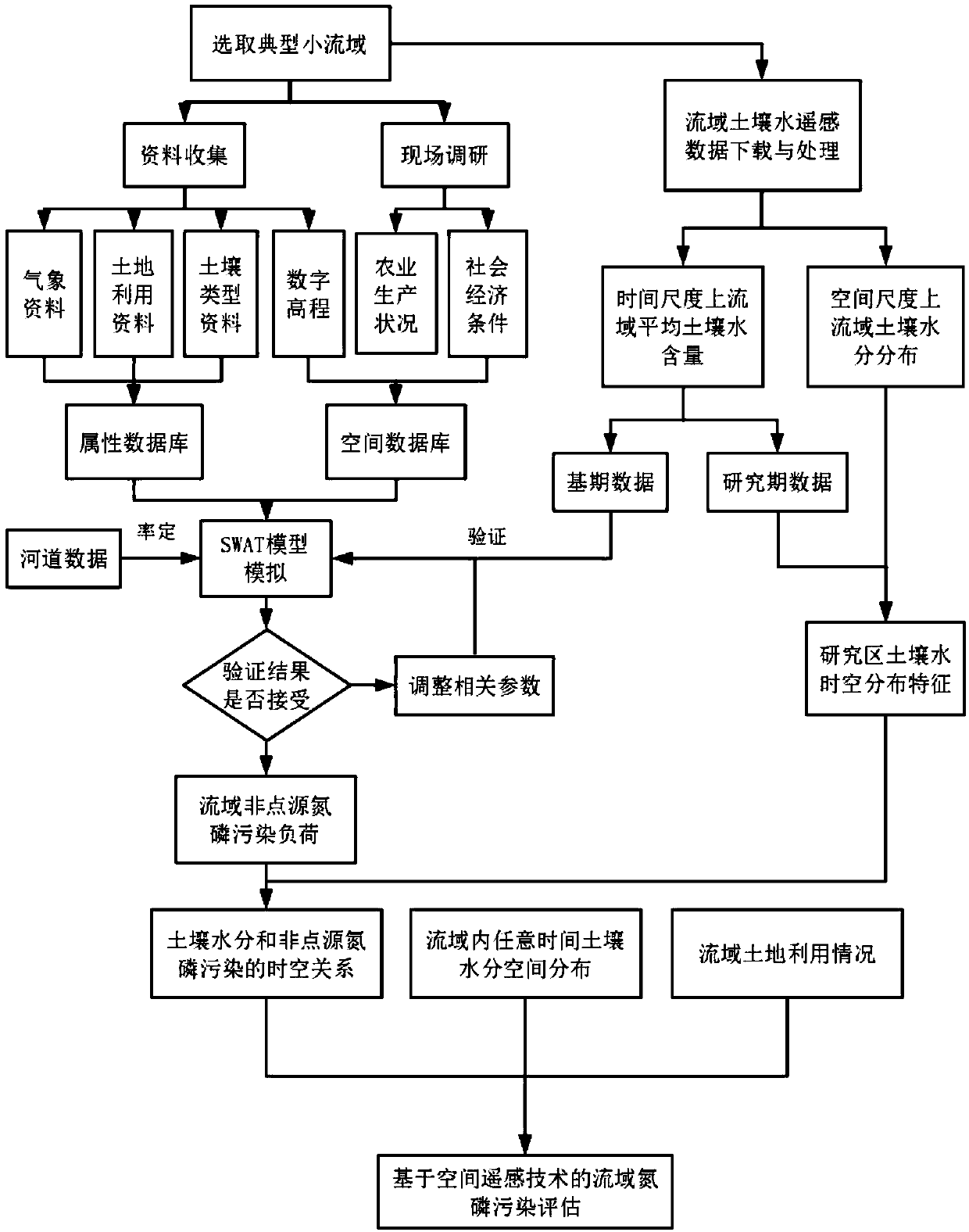
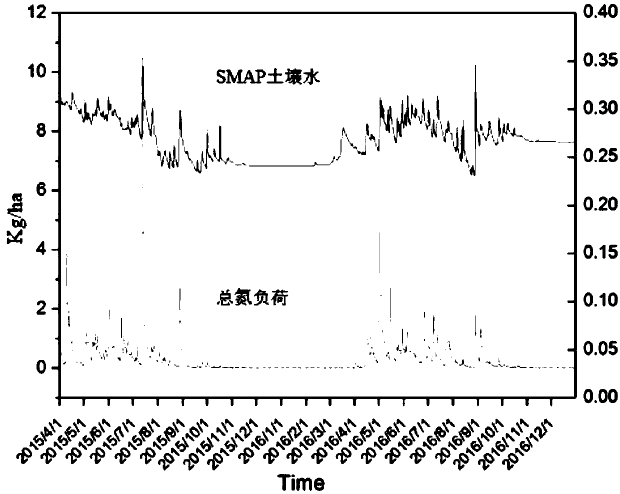
[0040] The watershed nitrogen and phosphorus pollution assessment method based on space remote sensing technology proposed by the present invention is a watershed SMAP soil water space remote sensing technology, based on the established relationship between soil moisture and non-point source pollution load, to quickly and effectively evaluate watershed non-point sources methods of source contamination.

[0041] See figure 1 , the present invention is a method for assessing nitrogen and phosphorus pollution in watersheds based on space remote sensing technology. The specific steps of the method are as follows:

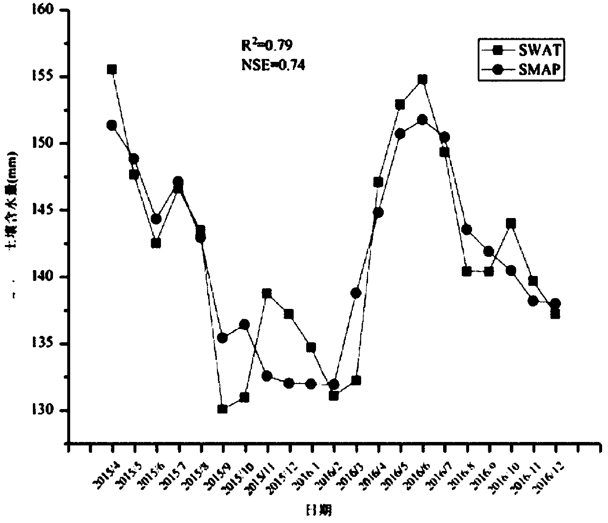
[0042] Step 1: Select a typical small watershed and obtain and analyze the SMAP soil water data of the whole watershed.

[0043] This case selects the Naoli River Basin, the largest watershed in the Sanjiang Plain, an important food producing area in Northeast China, as a case study. In this case, the L4 product with a resolution of 9km×9km in the SMAP data is selecte...


PUM


Abstract

The invention relates to a method for estimating nitrogen and phosphorus pollution in a drainage basin based on a spatial remote sensing technology. The method specifically comprises the following steps: step one: selecting a typical small drainage basin, acquiring and analyzing the soil moisture remote sensing data of the whole drainage basin; step two: carrying out drainage basin non-point source pollution SWAT model simulation; step three: using the drainage basin soil moisture spatial remote data to verify model simulation result; step four: establishing the soil moisture and non-point source nitrogen and phosphorus loss load response relationship; step 5: estimating nitrogen and phosphorus pollution in the drainage basin based on the spatial remote sensing technology. The method of the invention uses the remote sensing technology for analysis so as to avoid large-scale random sampling, improve the efficiency and feasibility of operation, and save cost; secondly, the method combines the soil moisture remote sensing technology and the SWAT model simulation, thereby improving the accuracy of the drainage basin non-point source nitrogen and phosphorus pollution simulation; thirdly, only by obtaining the soil moisture remote sensing data can the drainage basin non-point source pollution estimation be simply achieved.

Description

【Technical field】 [0001] The present invention is a watershed nitrogen and phosphorus pollution evaluation method based on space remote sensing technology, which belongs to the technical field of non-point source pollution management, and is a method for identifying the relationship between soil water and watershed non-point source nitrogen and phosphorus loss based on space remote sensing data. A method for accurately and efficiently assessing the loss of nitrogen and phosphorus from non-point sources. 【Background technique】 [0002] In recent years, my country's main point source pollution has been controlled, but the quality of water environment has not been significantly improved. Studies have shown that in some river basins, non-point source pollution has surpassed point source pollution and has become the main reason for the decline in water environment quality. Non-point source pollution is gradually attracting people's attention. Nowadays, with the development of a...

Claims


Application Information

Patent Timeline
IPC IPC(8): G06F17/50G06F17/18G06Q10/06
CPCG06F17/18G06Q10/063G06F30/20
Inventor 欧阳威杨博文高翔郝新魏鹏
Owner BEIJING NORMAL UNIVERSITY
Why Eureka
Try Eureka