Topological map based unmanned boat route searching system and method

A path search system and topology map technology, applied in radio wave measurement systems, satellite radio beacon positioning systems, measurement devices, etc., can solve problems such as local optimal search time, and achieve the effect of reducing algorithm complexity and improving efficiency

Active Publication Date: 2018-10-19
WUHAN UNIV OF TECH
View PDF4 Cites 29 Cited by
  • Summary
  • Abstract
  • Description
  • Claims
  • Application Information

AI Technical Summary

Problems solved by technology

Aiming at the problem that the current path search of unmanned boats is easy to fall into local optimum and the search time is long, the invention proposes a path search method for unmanned boats based on topological maps, and constructs the optimal path for unmanned boats to navigate

Method used


Image

  • Topological map based unmanned boat route searching system and method
  • Topological map based unmanned boat route searching system and method
  • Topological map based unmanned boat route searching system and method

Examples


Embodiment Construction

[0030] In order to make the object, technical solution and advantages of the present invention clearer, the present invention will be further described in detail below in conjunction with the accompanying drawings and embodiments. It should be understood that the specific embodiments described here are only used to explain the present invention, not to limit the present invention.

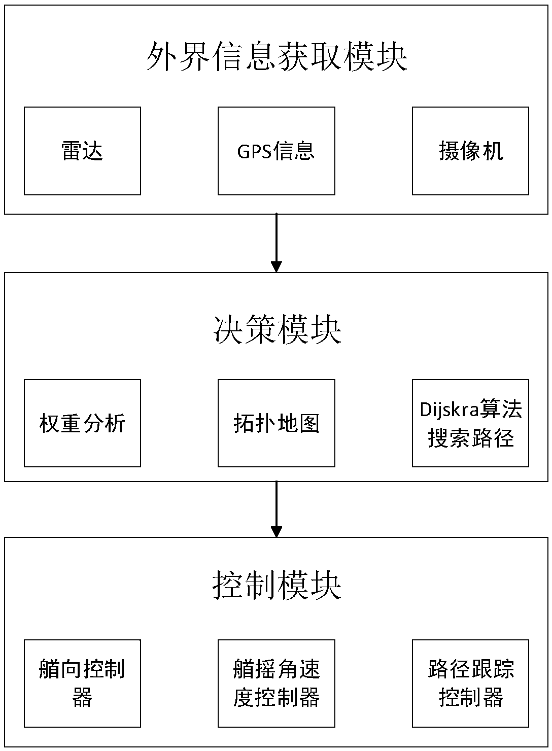
[0031] Such as figure 1 Shown, in the specific embodiment of the present invention:

[0032] Firstly, according to the external information acquisition module, the starting point and end position data, the number of obstacles and the obstacle edge point set in the search area of ​​the unmanned vehicle are obtained; the external information acquisition module includes GPS, radar and camera sensors, which are used to obtain external information. After obtaining external information, pass the information to the decision-making module.

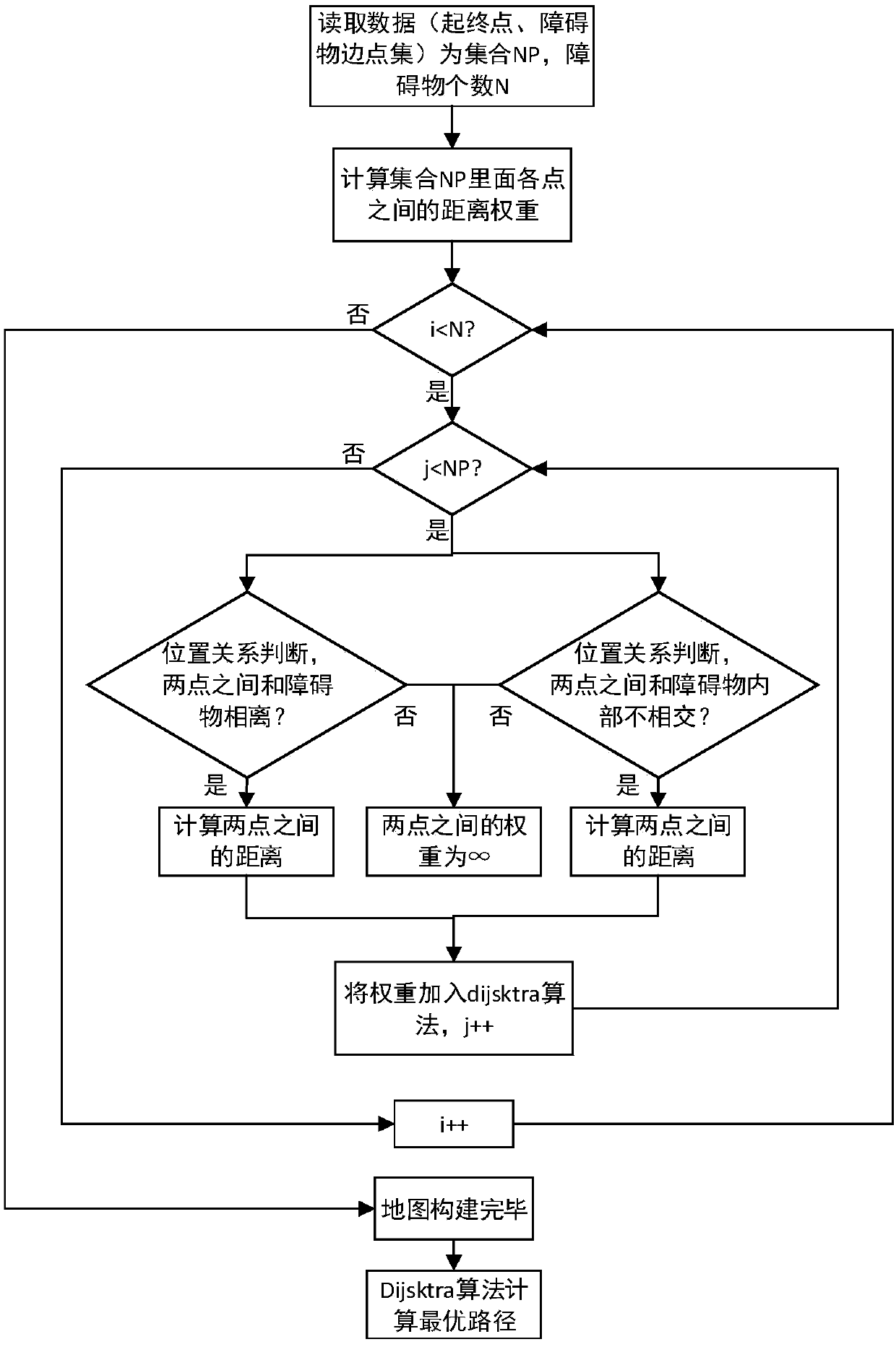
[0033] Such as figure 2 Shown:

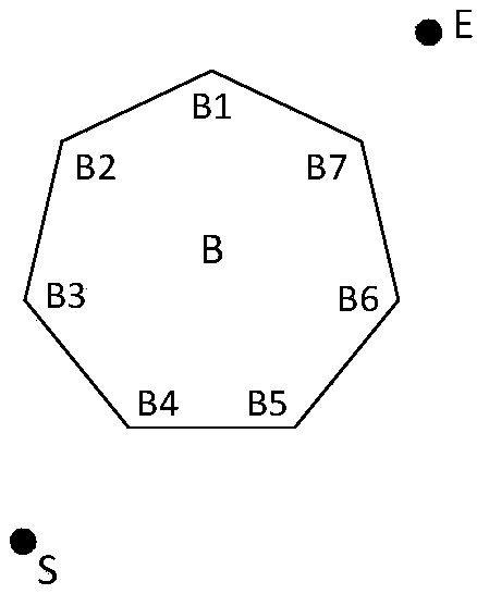
[0034] 1) Construct a spati...


PUM


Abstract

The invention discloses a topological map based unmanned boat route searching system and method. The method comprises following steps: step one, obtaining the external information of the searching area of an unmanned boat, wherein the external information comprises data of start position, final position, number of barriers, and edge point sets of barriers, based on the external information, carrying out route information analysis, based on the analysis result, establishing navigation topological relationship of the unmanned boat, and based on the topological relationship, establishing a spatial topological map; and step two, based on the established spatial topological map, a Dijskra algorithm, and navigation conditions of the unmanned boat, calculating the optimal path, and after the optical path is selected, controlling the track of the unmanned boat according to the optimal path. The method has the advantages that the optimal path that can meet the navigation requirements can be calculated out, the algorithm complexity is reduced, and the situation that route searching is trapped by local optimum is avoided.

Description

technical field [0001] The invention relates to the field of maritime intelligent transportation, in particular to a topological map-based unmanned boat path search system and method. Background technique [0002] In recent years, with the development of marine science and technology, unmanned vehicles have become an important research hotspot. Unmanned driving overcomes the shortcomings of driver fatigue and emotional change, and can work in dangerous areas and perform various marine tasks, such as marine sampling, search and rescue. In addition, it can also be used for military purposes such as target tracking, surveillance, reconnaissance, mine clearance and anti-submarine. In the development of unmanned boats, path search is one of the key technologies. Traveling salesman problem (Travel SalesmanProblem, TSP), various vehicle routing problems (Vehicle Routing Problem, VRP), route search based on road network, electronic map GPS navigation route search, routing problems...

Claims


Application Information

Patent Timeline
Patent Type & Authority Applications(China)
IPC IPC(8): G01C21/20G01S19/45
CPCG01C21/203G01S19/45
Inventor 周春辉顾尚定文元桥肖长诗杜哲何帆陈芊芊张奇
Owner WUHAN UNIV OF TECH
Why Eureka
Try Eureka