Satellite remote sensing atmospheric ozone profile inversion algorithm

A technology of satellite remote sensing and inversion algorithm, which is applied in the fields of environmental science and satellite remote sensing, and can solve problems such as the inability to strictly determine tropospheric ozone information, and achieve the effects of reducing algorithm errors, improving vertical resolution, and improving inversion accuracy

Inactive Publication Date: 2018-11-06
UNIV OF SCI & TECH OF CHINA
View PDF2 Cites 10 Cited by
  • Summary
  • Abstract
  • Description
  • Claims
  • Application Information

AI Technical Summary

Problems solved by technology

Compared with solar backscattering ultraviolet instruments, more low-level stratospheric ozone information can be obtained by inverting high-resolution hyperspectral...

Method used


Image

  • Satellite remote sensing atmospheric ozone profile inversion algorithm
  • Satellite remote sensing atmospheric ozone profile inversion algorithm
  • Satellite remote sensing atmospheric ozone profile inversion algorithm

Examples


Embodiment Construction

[0024] The embodiments of the present invention will be described in detail below, however, the embodiments of the present invention are not limited thereto. Based on the embodiments of the present invention, all other embodiments obtained by persons of ordinary skill in the art without making creative efforts belong to the protection scope of the present invention.

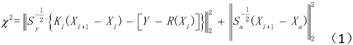
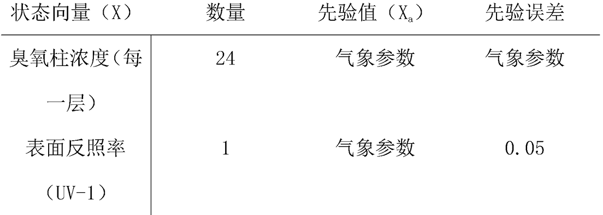
[0025] In the embodiment of the present invention, in order to achieve accurate inversion of atmospheric ozone profile information, the following ozone monitoring instrument-OMI radiation calibration and wavelength calibration steps are added to the algorithm software, that is, a satellite remote sensing atmospheric ozone profile inversion algorithm, Include the following steps:

[0026] Step 1: Radiation calibration and wavelength calibration using Ozone Monitoring Instrument-OMI; which includes:

[0027] (1) Adjustment of different spatial resolutions of the fitting window: select two windows of the ozone moni...


PUM


Abstract

The invention discloses a satellite remote sensing atmospheric ozone profile inversion algorithm, which comprises: 1, carrying out radiation calibration and wavelength calibration by using an ozone monitoring instrument OMI; 2, carrying out radiation transmission model and weighting function calculation; and 3, inverting atmospheric ozone profile information based on an optimal estimation technology algorithm by using the radiation spectrum simulation value and the weighting function parameter calculated in the step 2 after the radiation calibration and the wavelength calibration of the ozonemonitoring instrument OMI are completed. According to the present invention, the algorithm is established by using the OMI ultraviolet radiation spectrum data and selecting the fitting wave bands UV-1and UV-2, and can invert the atmospheric ozone profile information from the earth surface to the 60 km atmosphere based on the optimal estimation technology, wherein the atmospheric ozone profile information comprises the total ozone column concentration, the troposphere ozone column concentration and the stratosphere ozone column concentration, such that the troposphere atmosphere ozone profileis accurately inverted; and the method can be used for analyzing the relationship between atmospheric ozone convective motion, exchange processes, biomass burning and human pollution, and tracking thetemporal and spatial transport of ozone.

Description

technical field [0001] The invention relates to the fields of environmental science and satellite remote sensing technology, in particular to a satellite remote sensing atmospheric ozone profile inversion algorithm. Background technique [0002] Atmospheric ozone accounts for only a few millionths of each component in the air, but it has an important impact on global climate and environmental changes. Since the 1970s, total column ozone concentrations and ozone profiles have been derived from data measured by solar backscattered ultraviolet instruments aboard a series of NASA and NOAA satellites. Due to the low resolution of these instruments, only the (20-25km)-50km ozone vertical profile information and the ozone column concentration results above the cloud height can be retrieved from them. To obtain vertical ozone profile information at lower altitudes, high-resolution hyperspectral instruments are required. Compared with solar backscattering ultraviolet instruments, m...

Claims


Application Information

Patent Timeline
IPC IPC(8): G01N21/33
CPCG01N21/33G01N2021/1793
Inventor 刘诚
Owner UNIV OF SCI & TECH OF CHINA
Why Eureka
Try Eureka