Vehicle laser radar data city road shaft identification algorithm based on multi-frame joint

A vehicle-mounted lidar, multi-frame combination technology, applied in scene recognition, character and pattern recognition, calculation and other directions, can solve the problems of large amount of calculation, low recognition rate, missed detection and other problems, achieve small amount of calculation, sufficient feature extraction, The effect of high recognition rate

Active Publication Date: 2018-11-06
STATE GRID LIAONING ELECTRIC POWER RES INST +1
View PDF3 Cites 11 Cited by
  • Summary
  • Abstract
  • Description
  • Claims
  • Application Information

AI Technical Summary

Problems solved by technology

Its purpose is to solve the problems of insufficient feature extraction, low recognition rate, large amount of calculation, and missed detection in the existing urban road pole recognition system.

Method used


Image

  • Vehicle laser radar data city road shaft identification algorithm based on multi-frame joint
  • Vehicle laser radar data city road shaft identification algorithm based on multi-frame joint

Examples


Embodiment 1

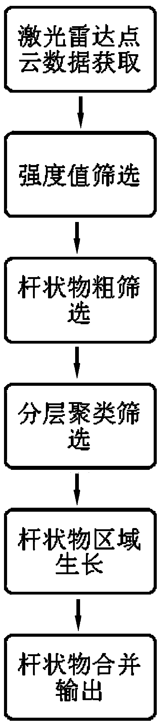
[0027] like figure 1 As shown, the present invention is a kind of urban road rod recognition algorithm based on multi-frame joint vehicle laser radar data, comprising the following steps:

[0028] 1. LiDAR point cloud data acquisition.

[0029] Because the point cloud data of a single frame is relatively sparse, which is not conducive to object recognition, in order to better identify rods, the present invention uses multi-frame joint point cloud data. The multi-frame joint mainly uses the ICP (Iterative Closest Point) algorithm, and its key idea is to find corresponding point pairs to achieve the purpose of point cloud splicing, thereby forming dense point cloud data. Therefore, the amount of point cloud data after splicing is large, and preprocessing and screening are required.

[0030] The pretreatment screening includes three steps: intensity value screening, rod rough screening and hierarchical clustering screening.

[0031] 2. Intensity value screening.

[0032] Afte...

Embodiment 2

[0055] There are a total of 600 frames of experimental data in this experiment, and these experimental data are tested one by one, and the recognition results of all experimental data are collected for statistics.

[0056] For the 600 frames of 32-line radar data measured, 120 frames were extracted every 5 frames for statistics of the experimental results, and the recall rate (Recall) and recognition rate (Precision) were counted.

[0057] Recall = true rods / all rods

[0058] Accuracy (Precision) = Truly a rod / Algorithm detects a rod

[0059] After manually counting 2130 rod-shaped objects, the algorithm detected 2098 rod-shaped objects, of which 1970 were actually rod-shaped objects, so the recall rate was 92.49% and the accuracy rate was 93.90%.


PUM


Abstract

The present invention belongs to the technical field of artificial intelligence, especially relates to a vehicle laser radar data city road shaft identification algorithm based on multi-frame joint. The algorithm comprises the following steps of: laser radar point cloud data obtaining; screening of an intensity value; coarse screening of a shaft; layered clustering screening; shaft area growth; and shaft combination output. Through adoption of the multi-frame joint technology, the point cloud features of the shaft is more obvious so as to better facilitate identification of the shaft. The vertical voxelization, layered clustering and area growth technologies are employed to allow the vehicle laser radar data city road shaft identification algorithm to have full feature extraction, high identification and few computing quantity. The vehicle laser radar data city road shaft identification algorithm provides rapid and effective shaft identification at the aspects of vehicle map construction, checking of electric rods or road lamps,, three-dimensional reconstruction and detection of buildings, road condition survey and analysis, road measurement and prospecting so as to achieve intelligent traffic and intelligent industry.

Description

technical field [0001] The invention belongs to the technical field of artificial intelligence, and in particular relates to an urban road pole-shaped object recognition algorithm based on multi-frame combined vehicle-mounted laser radar data. Background technique [0002] LiDAR technology (Light Detection And Ranging- LiDAR) is a new technology for information acquisition and automatic processing of digital cities, digital industries, and transportation infrastructure construction. It provides a simple and efficient way to obtain urban infrastructure data. It is widely used in the construction of vehicle maps, inventory of poles or street lamps, three-dimensional reconstruction and detection of buildings, investigation and analysis of road status, road measurement and survey, etc. Lidar can effectively and quickly acquire high-precision three-dimensional space information on both sides of the road, providing a new means for realizing intelligent transportation and intellige...

Claims


Application Information

Patent Timeline
Patent Type & Authority Applications(China)
IPC IPC(8): G06K9/00G06K9/62G01S17/93G01S7/48
CPCG01S7/48G01S17/931G06V20/13G06V2201/07G06F18/23
Inventor 李桐刘扬陈得丰耿洪碧李欢杨志斌任帅
Owner STATE GRID LIAONING ELECTRIC POWER RES INST
Why Eureka
Try Eureka