Method and system for estimating population density in urban built-up areas by cooperation with spatial big data

A technology of population density and built-up areas, applied in the field of urban remote sensing and urban demography, can solve the problem that population spatialization products cannot accurately describe the actual spatial distribution characteristics of the population in urban built-up areas

Active Publication Date: 2018-11-23
INST OF REMOTE SENSING & DIGITAL EARTH CHINESE ACADEMY OF SCI
View PDF4 Cites 47 Cited by
  • Summary
  • Abstract
  • Description
  • Claims
  • Application Information

AI Technical Summary

Problems solved by technology

[0005] Aiming at the problem that traditional population spatialization products based on land use / land cover data and optimized parameters cannot accurately describe the actual spatial distribution characteristics of population in urban built-up areas, the present invention provides a method for estimating the population density of urban built-up areas with spatial big data collaboration, Based on the range and height of buildings extracted from high-resolution optical remote sensing data and remote sensing optical stereoscopic imaging data, the population density estimation model is collaboratively constructed using road network and spatial big data of interest points, and the fine population density estimation of urban built-up areas is realized.

Method used


Image

  • Method and system for estimating population density in urban built-up areas by cooperation with spatial big data
  • Method and system for estimating population density in urban built-up areas by cooperation with spatial big data
  • Method and system for estimating population density in urban built-up areas by cooperation with spatial big data

Examples


Embodiment Construction

[0045] The present invention will be described below in conjunction with the accompanying drawings.

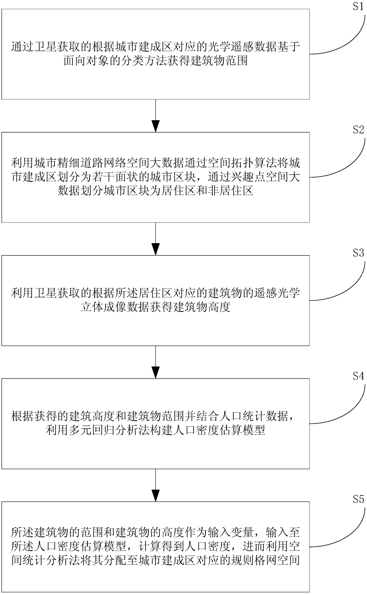
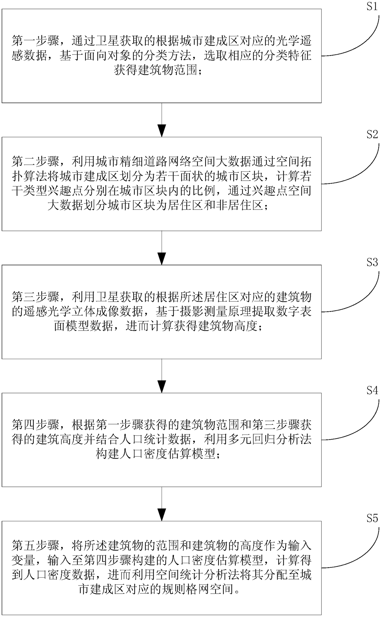
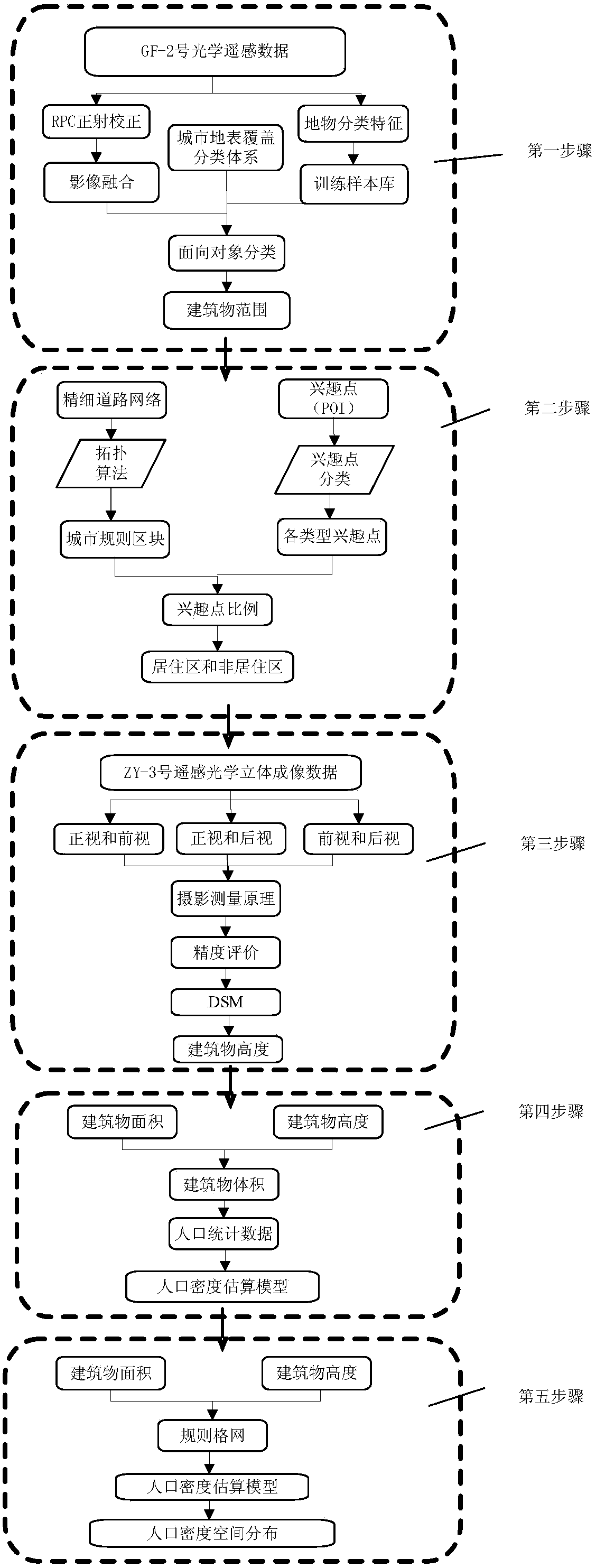
[0046] The present invention relates to a method for estimating the population density of urban built-up areas with spatial big data collaboration, and its flow chart is as follows figure 1 As shown, the method includes the following steps: S1: Obtain the range of buildings based on the object-oriented classification method based on the optical remote sensing data corresponding to the urban built-up area obtained through satellites; S2: use the urban fine road network space big data to map The urban built-up area is divided into several planar urban blocks, and the urban blocks are divided into residential areas and non-residential areas through spatial big data of points of interest; S3: the remote sensing optical stereoscopic view of the buildings corresponding to the residential areas obtained by satellite Obtain the building height from the imaging data; S4: According to t...


PUM


Abstract

The invention relates to a method and a system for estimating population density in urban built-up areas coordinated by spatial big data. The method comprises the following steps: obtaining a buildingrange based on an object-oriented classification method by utilizing high-resolution optical remote sensing data; dividing urban blocks through a spatial topology algorithm by utilizing spatial big data of an urban fine road network, and dividing the urban blocks into residential areas and non-residential areas by combination with spatial big data of points of interest; obtaining building heightby utilizing remote sensing optical three-dimensional imaging data; constructing a population density estimation model by utilizing a multiple regression analysis method according to the building height and the building range and by combination with population statistical data; and inputting the building range and the building height as input variables into the population density estimation model,performing calculation to obtain population density, and then, assigning the population density to regular grid space corresponding to urban built-up areas by utilizing a spatial statistical analysismethod. The method and the system can precisely and accurately realize estimation of the population density in the built-up urban areas, are more suitable for requirements of urban planning, disasterprevention and reduction and business decision for fine population data, and are beneficial to further popularization and application.

Description

technical field [0001] The invention relates to the technical field of urban remote sensing and urban demography, in particular to a method and system for estimating the population density of urban built-up areas with spatial big data collaboration. Background technique [0002] Population density distribution is the spatial manifestation of population process, and urban population density distribution and simulation are important contents in the study of urban spatial structure and suburbanization. Scholars at home and abroad have used mathematical models to reveal the general law of urban population density distribution based on the characteristics of "circle-type" cities. These studies analyze the spatial distribution of population density based on statistical data, assuming that the population is continuously and evenly distributed within the census area, but the actual population distribution is not continuous. Internationally, many institutions are committed to the re...

Claims


Application Information

Patent Timeline
Patent Type & Authority Applications(China)
IPC IPC(8): G01C11/02G01S19/01
CPCG01C11/02G01S19/01
Inventor 王世新周艺刘文亮王丽涛朱金峰
Owner INST OF REMOTE SENSING & DIGITAL EARTH CHINESE ACADEMY OF SCI
Why Eureka
Try Eureka