Method and system for automatically updating highway spatial data

A spatial data and automatic update technology, applied in the direction of electrical digital data processing, special data processing applications, instruments, etc., can solve the problems of limited coverage, low technical efficiency, long time consumption, etc., to improve accuracy and current situation, and widely Application promotion value, effect of reducing manpower and time

Active Publication Date: 2018-11-27
BEIJING TECHNOLOGY AND BUSINESS UNIVERSITY
View PDF4 Cites 5 Cited by
  • Summary
  • Abstract
  • Description
  • Claims
  • Application Information

AI Technical Summary

Problems solved by technology

Zhu Huimin et al. proposed an automatic incremental recognition and update technology for traffic network vector data based on buffer analysis. This technology can well ensure the inheritance correlation between current data and historical data; but the disadvantage is that it is not automatic. Update, it is necessary to manually edit attributes on the road network, which strongly depends on the accuracy of manual work
Wu Tao et al. proposed a spiral road network data update strategy based on HMM trajectory map matching for large-scale data updates. This strategy can well meet the needs of autom

Method used


Image

  • Method and system for automatically updating highway spatial data
  • Method and system for automatically updating highway spatial data
  • Method and system for automatically updating highway spatial data

Examples


Embodiment Construction

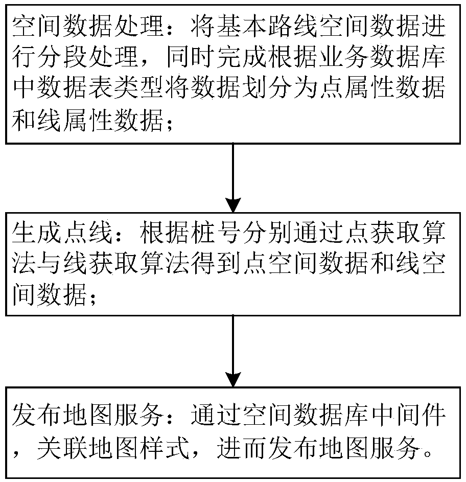
[0052] In the following, the present invention will be further described by taking the process of automatically updating a group of road data as an example in conjunction with the accompanying drawings.

[0053] The present invention provides a method and system for automatic updating of highway spatial data, abandoning the current mode of intercepting and manually sorting spatial data, manually storing and manually associating attribute data, and adopting the method of generating point lines according to a specific algorithm after obtaining data from a business database , and then associate the generated point-line spatial data with the style, and finally publish the map service to the front-end visible one-click automatic update mode. The specific method flow chart is attached figure 1 As shown, it includes: 1) spatial data processing: process the basic route spatial data in segments, and divide the data into point attribute data and line attribute data according to the data...


PUM


Abstract

The invention discloses a method and system for automatically updating highway spatial data. The method comprises the steps of spatial data processing, point line generating and map service publishing; initial data in a service database is extracted and processed, and according to starting and ending station numbers and a center station number of a highway, point attribute data and line attributedata are distinguished; according to the station numbers, the point attribute data is subjected to a point acquisition algorithm to obtain corresponding point spatial data, and the line attribute datais subjected to a line acquisition algorithm to obtain corresponding line spatial data; through middleware in the spatial database, map styles are associated, and map services are published; automatic update of the highway spatial data based on GIS is achieved. The method achieves the automatic updating of the highway spatial data, can achieve the efficient and accurate updating of a large amountof data, enhances the current situation of the data, can greatly reduce the manpower and time required for annual update and maintenance of the highway data, has high economic benefits and commercialvalue, and can be widely promoted and applied.

Description

technical field [0001] The invention belongs to the technical field of road space data processing, and relates to a method for automatically extracting road space data and publishing map services, in particular to a method for automatically extracting and publishing road space data and automatically updating attribute data based on GIS. Background technique [0002] During the design and construction of the highway system, a large amount of highway asset data is generated. With the adjustment of the road network and the improvement of road facilities, the content and volume of highway data are also changing. How to efficiently and high-quality highway data , Sustainable automatic update is a key technical problem to be solved urgently. Road spatial data update refers to the process of comparing the road data obtained by the collection vehicle or other effective means with the original road data to form a new cycle of road data, and the process of spatial data acquisition, as...

Claims


Application Information

Patent Timeline
IPC IPC(8): G06F17/30
Inventor 张珣靳敏王浩宇赵霞刘静文刘文文于重重
Owner BEIJING TECHNOLOGY AND BUSINESS UNIVERSITY
Why Eureka
Try Eureka