
Real-time acquisition and analysis method and system for potential safety hazard information of tourist location in intelligent scenic spot

A technology of real-time collection of safety hazards, applied in transmission systems, instruments, electrical components, etc., can solve problems such as untimely update of safety hazard information, inaccurate location safety hazard information of tourists in scenic spots, etc., to meet real-time requirements and reduce manpower and financial waste, the effect of improving efficiency

Pending Publication Date: 2018-12-07
GUILIN UNIVERSITY OF TECHNOLOGY
View PDF0 Cites 8 Cited by
  • Summary
  • Abstract
  • Description
  • Claims
  • Application Information

AI Technical Summary

Problems solved by technology

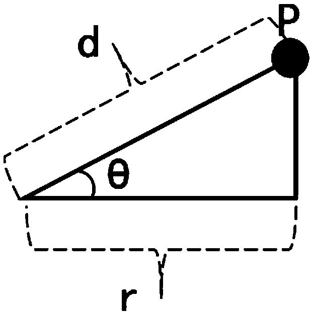
Considering the slope change of the scenic spot, the hidden danger buffer zone analysis of the collected point hidden dangers, line hidden dangers and surface hidden dangers data taking into account the slope of the terrain is carried out, and the real-time spatial analysis technology of GIS is used to plot the range of existing or potential hidden dangers in the scenic spot, which can Collect the hidden danger data of existing scenic spots and conduct real-time spatial analysis on them to meet the requirements of real-time update and warehousing of smart scenic spots, and solve the key problems of untimely updating of hidden danger information used for hidden danger warning in scenic spots and inaccurate hidden danger information of tourists in scenic spots

Method used


Image

  • Real-time acquisition and analysis method and system for potential safety hazard information of tourist location in intelligent scenic spot
  • Real-time acquisition and analysis method and system for potential safety hazard information of tourist location in intelligent scenic spot
  • Real-time acquisition and analysis method and system for potential safety hazard information of tourist location in intelligent scenic spot

Examples


Embodiment Construction

[0038] In order to illustrate the technical solution of the present invention more clearly, the present invention will be described in detail below in conjunction with specific examples. The following examples will help those skilled in the art to better understand the present invention.

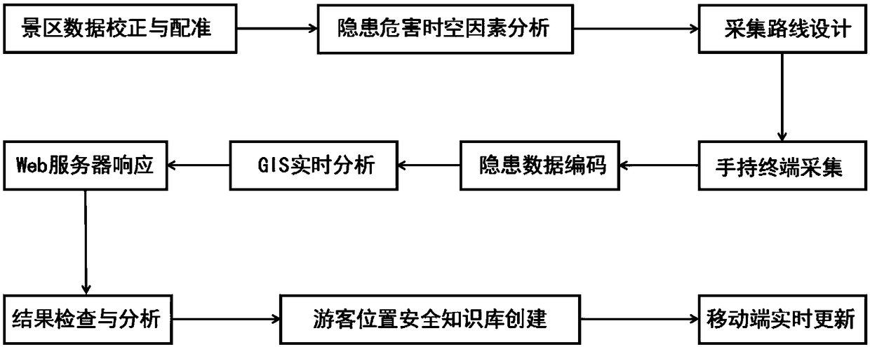
[0039] figure 1 A flow chart of a method for real-time collection and analysis of hidden danger information on the location of tourists in a smart scenic spot is shown, and the detailed steps are as follows:

[0040] (1) Scenic spot data correction and registration: Obtain the high-scoring satellite image data of the scenic spot in recent years (spatial resolution higher than 1 meter), use the LocaSpaceViewer software, "select operation" menu, click the high-scoring image download, and draw The range of regions to download. A number of uniformly distributed point coordinates that have not changed in recent years are selected as high-resolution image geocorrection and registration control po...


PUM


Abstract

The invention discloses a real-time acquisition and analysis method and system for potential safety hazard information of a tourist location in an intelligent scenic spot. The real-time acquisition and analysis method for potential safety hazard information of the tourist location in the intelligent scenic spot provided by the embodiment of the invention comprises the following steps: acquiring coordinate information of potential safety hazard of a tourist through a handheld terminal, and connecting acquired hidden danger data and a spatial analysis request with a GIS spatial analysis server through a Web server in real time to realize buffer zone analysis with consideration of slope; and calculating the radius of a hidden danger buffer zone and early warning level parameter information inreal time based on a scenic spot location safety knowledge base and the information of rainfall and water depth sensors, and saving knowledge formed during an analysis process. The technical scheme is easy to grasp and achieves the processing and warehousing technical effects of real-time acquisition and real-time analysis. Moreover, the embodiment of the invention provides a set of real-time acquisition and analysis system, which significantly reduces the workload of subsequent data analysis and warehousing arrangement, and improves the efficiency of scenic spot hidden danger information acquisition, analysis and warehousing.

Description

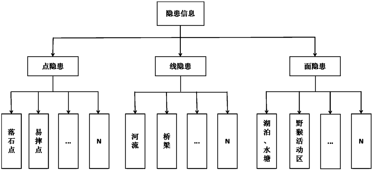
technical field [0001] The invention relates to the field of real-time intelligent processing of GIS information in scenic spots, and in particular to a method and system for real-time collection and analysis of information on potential safety hazards of tourists in intelligent scenic spots. Background technique [0002] The safety of tourists is very important to scenic spots. The natural scenery emphasized by words such as "odd" and "dangerous" in scenic spots often hides many natural and artificial hidden dangers that threaten tourists. With the vigorous development of the smart tourism industry, the number of people in scenic spots is increasing day by day, and the safety problems of scenic spots are increasing day by day. Many scenic spots and scenic spots have complex topography and landforms, and there are many hidden dangers in the shape of points, lines and planes, which are randomly distributed in the scenic spot, which poses a great threat to the safety of tourist...

Claims


Application Information

Patent Timeline
IPC IPC(8): H04L29/08G06Q50/14
CPCH04L67/025H04L67/12G06Q50/14H04L67/52
Inventor 李百寿谢跃辉梁石海沈宇臻姚登敏
Owner GUILIN UNIVERSITY OF TECHNOLOGY
Learn More