A method for calculating permeability tensor of fractured rock mass based on measured structural plane parameters

A technique of seepage tensor and fractured rock mass, which is applied in the field of geotechnical survey and hydrogeology, can solve the problem of low iteration efficiency, achieve the effects of ensuring calculation accuracy, reducing manual statistical errors, and improving efficiency

Active Publication Date: 2018-12-18
NANJING UNIV OF SCI & TECH
View PDF5 Cites 14 Cited by
  • Summary
  • Abstract
  • Description
  • Claims
  • Application Information

AI Technical Summary

Problems solved by technology

However, when adding a set of bonding definitions of structural surfaces, the iteration efficiency will be very low because the node weights of this group of iterations are much smaller than the node weights of other groups.

Method used


Image

  • A method for calculating permeability tensor of fractured rock mass based on measured structural plane parameters
  • A method for calculating permeability tensor of fractured rock mass based on measured structural plane parameters
  • A method for calculating permeability tensor of fractured rock mass based on measured structural plane parameters

Examples


specific Embodiment approach

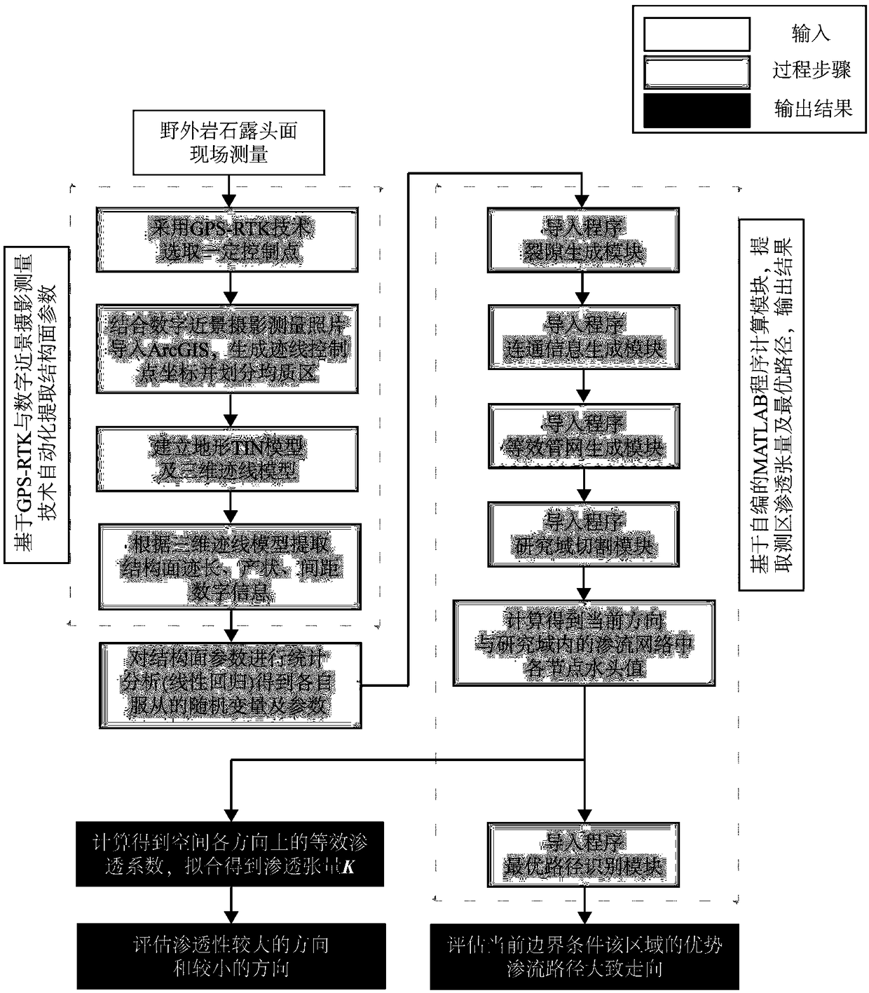
[0032] As a specific implementation, the specific modeling process is:

[0033] Step 3.1, in the digital terrain model DTM (Digital Terrain Model), select a more flexible and higher-precision irregular triangulated network TIN model (Triangulated Irregular Network) based on the Delaunay triangulation algorithm to simulate the rock outcrop in the homogeneous area to be measured;

[0034] Step 3.2, after obtaining the TIN model of the outcropping surface, combined with the three-dimensional space coordinates of the trace obtained in step 2, interpolation is performed on the basis of the TIN model with a rectangular grid to obtain a rectangular grid terrain surface;

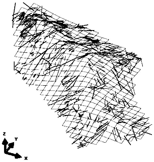
[0035] Step 3.3. The model established by superimposing the rectangular grid terrain surface and the three-dimensional space coordinates of the trace is called the "three-dimensional trace model", which is equivalent to the digital sample of the real outcrop. The data information of the model can be extracted by mean...

Embodiment 1

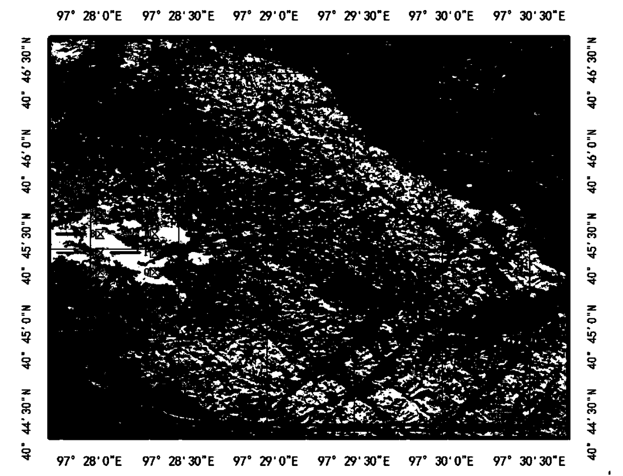
[0068] In order to verify the effectiveness of the scheme of the present invention, this embodiment takes the rock structure plane of the granite CDER area in the Jiji trough area of ​​Beishan, Gansu Province as the research object to carry out the calculation of the permeability tensor, including the following steps:

[0069] (1) Mark control points and take photos of outcrops

[0070] First, 5 to 12 control points are marked on the rock outcrop in the selected area by the GPS-RTK method, so as to accurately locate the coordinates of the structural surface trace, and then the outcrop is used in different directions (6 and above) using close-range digital Photogrammetry technology to take high-definition photos;

[0071] (2) Acquisition of trace information and division of homogeneous regions

[0072] Obtain structural surface trace information: the control points should not be on the same straight line and should be greater than two points, so that the structural surface occ...


PUM


Abstract

The invention discloses a method for calculating and optimizing the permeability tensor of fractured rock mass based on measured structural plane parameters, which marks control points on the rock outcrop surface and takes pictures of the rock outcrop surface from different angles at the same time. The three-dimensional coordinates of the control points of the structural plane traces on the photographs are located according to the coordinates of the marked control points, and the homogeneous regions are divided according to the clustering degree of the control points on the structural plane traces. According to the coordinates of the control points of the structural plane traces, a three-dimensional model of the structural plane traces in the homogeneous region to be measured is established. According to the three-dimensional model of structural plane traces, the information of structural plane traces length, occurrence and spacing is extracted. Statistical analysis of trace length, occurrence and spacing of structural planes is carried out to determine the random distribution types and parameters obeyed by them. According to the type and parameter of random distribution, the permeability tensor of the homogeneous area to be measured is calculated. The invention improves the accuracy and efficiency of the structural plane information processing, and simultaneously improves thecalculation efficiency of the infiltration tensor and the optimal path identification in the calculation module.

Description

technical field [0001] The invention relates to the fields of geotechnical survey and hydrogeology, in particular to a method for calculating the permeability tensor of fractured rock mass based on actually measured structural surface parameters. Background technique [0002] The permeability tensor is an important parameter to evaluate the permeability of rock mass, and it is mainly divided into two parts: the acquisition of structural surface parameters and the calculation of the permeability tensor. The measurement methods of structural surface parameters mainly include artificial on-site contact measurement method, drilling method, three-dimensional laser scanning technology, photogrammetry and GPS-RTK technology. The real-time differential GPS measurement technology that effectively combines data transmission technology and GPS measurement technology has the advantages of high positioning accuracy, strong comprehensive surveying and mapping capabilities, and easy operat...

Claims


Application Information

Patent Timeline
Patent Type & Authority Applications(China)
IPC IPC(8): G06F17/50G01N15/08
CPCG01N15/08G06F30/20
Inventor 章杨松王鑫永李晓昭许文涛
Owner NANJING UNIV OF SCI & TECH
Why Eureka
Try Eureka