Method and system of land law enforcement dynamic patrol based on 3S integration technology

A land-based and dynamic technology, applied in transmission systems, digital transmission systems, structured data retrieval, etc., can solve the problem of difficulty in accurately locating and analyzing patterns and the nature of the land occupied by them, easy confusion affecting project progress, and satellite image verification. Problems such as heavy workload, to achieve the effect of promoting the redevelopment of the stock land, saving the time for making and printing drawings, and strengthening the protection of land resources

Inactive Publication Date: 2019-01-04
湖南中科星图信息技术股份有限公司
View PDF3 Cites 20 Cited by
  • Summary
  • Abstract
  • Description
  • Claims
  • Application Information

AI Technical Summary

Problems solved by technology

[0004] The purpose of the present invention is to intelligently and finely solve the heavy workload of satellite image verification, it is difficult to accurately locate and analyze the map spots and the properties of the

Method used


Image

  • Method and system of land law enforcement dynamic patrol based on 3S integration technology
  • Method and system of land law enforcement dynamic patrol based on 3S integration technology
  • Method and system of land law enforcement dynamic patrol based on 3S integration technology

Examples


Embodiment 1

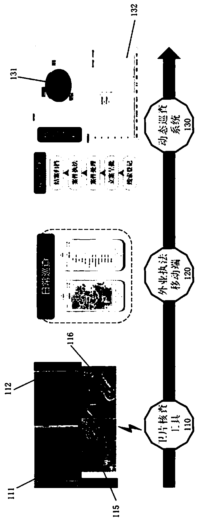
[0050] A land law enforcement dynamic inspection method based on 3S integration technology, the method includes the following steps:

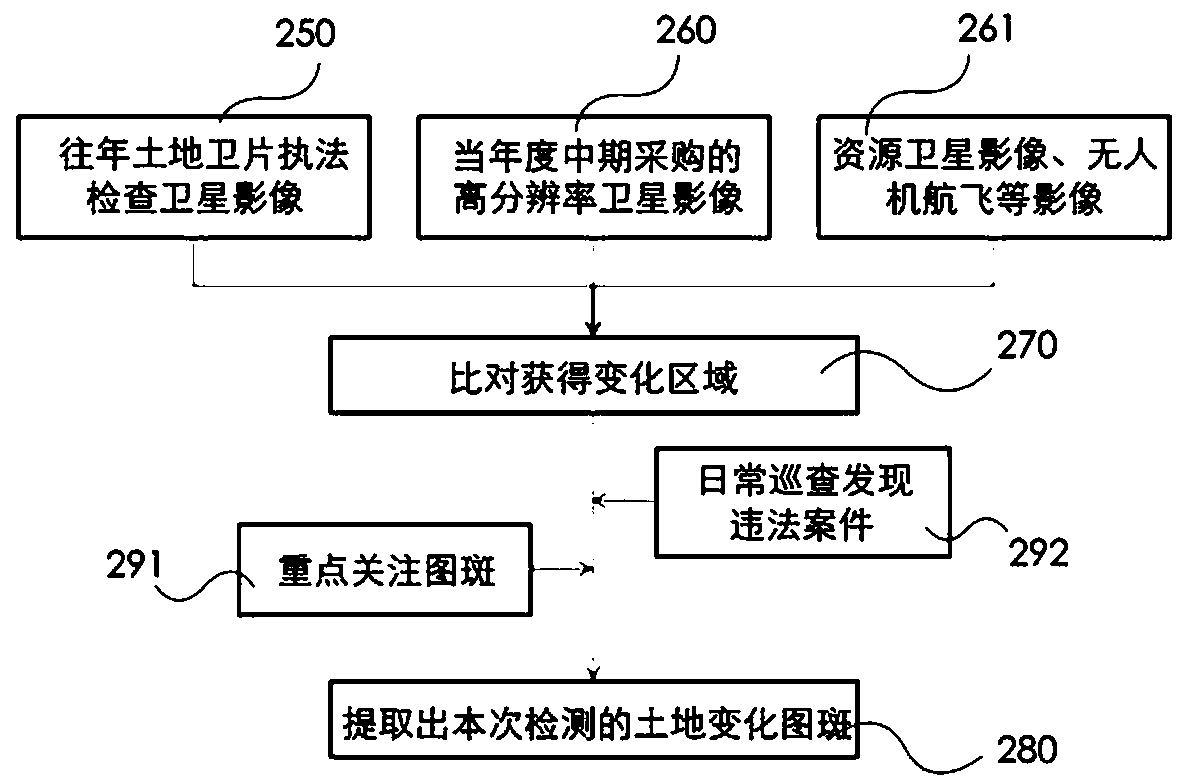
[0051] Step 1: The server-side GIS system obtains the multi-source multi-temporal satellite image 112 and / or aerial image data of the current year, and the current year multi-source multi-temporal satellite image 112 and / or aerial image data obtained by the GIS database 111 of the land law enforcement status in previous years and the GIS Compare and analyze the extracted change area 116 with the patch data, and integrate the GIS database of the status quo of land law enforcement to form a land change map with attribute information and boundary information 280;

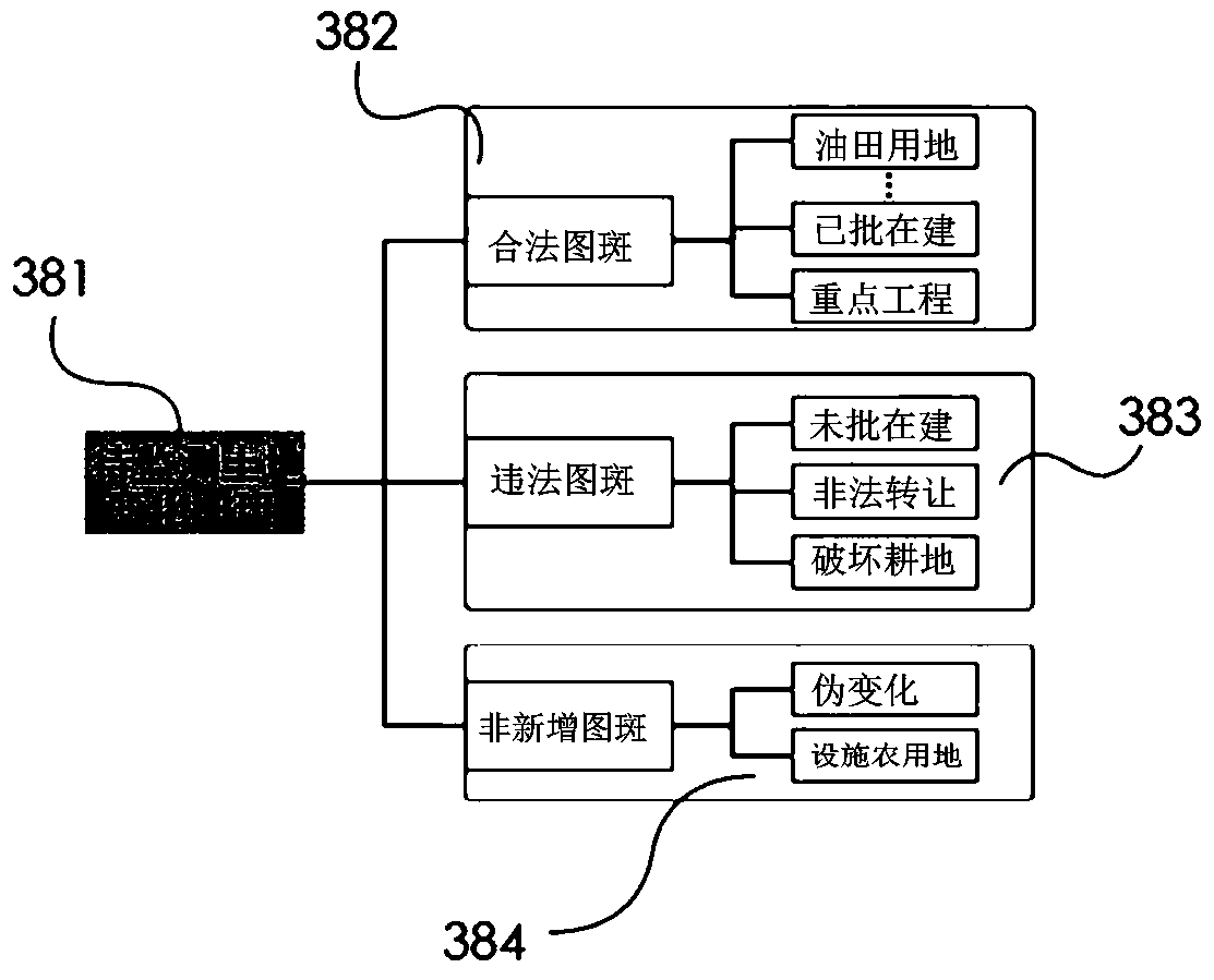
[0052] Step 2: The GIS system obtains and compares the obtained land change map 280 and calls the legal land use data approved by the Land and Resources Bureau, and marks the legal map in the land change map 280 to obtain the land change map 381 to be monitored;

[0053] Step 3: The ser...

Embodiment 2

[0061] On the basis of Example 1, in the step 2, the change map 292 and / or the key attention map 291 of the illegal cases found in the daily inspection are acquired in the land change map library to be monitored.

[0062] Step 3.1 is also included between the steps 3 and 4: manually intervene to screen the changed patterns uploaded by users in the WeChat client, and establish a legal pattern database 382, ​​an illegal pattern database 383 and a non-new pattern database 384.

[0063] The land law enforcement dynamic patrol based on 3S integration technology consists of three parts,

[0064] The mobile inspection terminal is WeChat client 511;

[0065] The verification tool for satellite law enforcement is to obtain multi-source and multi-temporal satellite and / or aerial data based on the GIS system for the current year. Compare and analyze the patch data to extract the change area, integrate the GIS database of the status quo of land law enforcement, and form a land change map...

Embodiment 3

[0104] A land law enforcement dynamic inspection method based on WeChat platform and 3S integration technology, the method includes the following steps:

[0105] Step 1: Obtain the user login request and user identity information of the WeChat client 511 from the WeChat public platform 510;

[0106] Step 2: The user login request and user identity information are sent to the server 520 through the WeChat public platform 510 to verify the user identity information of the WeChat client 511. If the verification of the user identity information of the WeChat client 511 is passed, the server 520 and WeChat Communicate between the clients 511; if the verification of the user identity information of the WeChat client 511 fails, the server 520 rejects the user login request of the WeChat client 511;

[0107] Step 3: The WeChat client 511 obtains the land change map with attribute information and spatial information from the GIS database of the current status of land law enforcement in...


PUM


Abstract

The invention relates to a land law enforcement dynamic patrol method and system based on 3S integrated technology, belonging to the field of land law enforcement supervision, comprising a satellite film verification tool, a mobile patrol terminal and a land law enforcement dynamic patrol management system. The satellite photograph verification tool adopts automatic extraction mechanism of changeplaques, assists in extracting the range of change plaques, examines the legitimacy of land use types of change, grasps the illegal land use location at the first time, and provides guidance for the investigation and punishment of illegal cases. The mobile patrol terminal connection server can send the land change patch data corresponding to the land change patch database matched with the accountnumber authority according to the registered account number information, and the land change patch data is provided with attribute information and spatial information. The land law enforcement dynamicpatrol management system is based on B/S terminal, which integrates the business system of reporting, issuing, adducing evidence, examining and approving, filing, data analysis and so on, and realizes the visual law enforcement process and the automation transfer mode of business processing by combining diagrams and charts.

Description

technical field [0001] The invention relates to land law enforcement supervision, in particular to a land law enforcement dynamic inspection method and system based on 3S integration technology. Background technique [0002] Strengthening the protection of cultivated land and curbing illegal use of land is an important responsibility of land and resource management. At present, our province conducts a full-coverage law enforcement inspection of satellite images every year, which has effectively curbed land violations and initially formed the law enforcement concept of "discovery at the initial stage and solution in the bud" of land and resources departments at all levels. However, for county-level (township) grass-roots land law enforcement departments, especially for illegal building and illegal land occupation in rural areas in remote areas, the annual satellite coverage can no longer meet the needs. At the same time, due to the large number of changing maps and heavy wor...

Claims


Application Information

Patent Timeline
IPC IPC(8): G06Q50/26G06F16/29H04L12/58
CPCH04L51/046G06Q50/26H04L51/222
Inventor 李建辉陶文武罗望军周小群吴亚军潘智
Owner 湖南中科星图信息技术股份有限公司
Why Eureka
Try Eureka