Effective area determination method for early dynamic identification and monitoring of regional landslides based on insar technology

A technology of effective area and determination method, applied in scene recognition, character and pattern recognition, measurement devices, etc., can solve the problem of inability to effectively identify all the monitoring target mountainous areas, especially high mountains and valleys, inability to accurately identify the real effectiveness of monitoring results, InSAR technology Difficulty and other problems to achieve the effect of improving practicability and accuracy

Active Publication Date: 2021-10-01
中国地质环境监测院
View PDF5 Cites 0 Cited by
  • Summary
  • Abstract
  • Description
  • Claims
  • Application Information

AI Technical Summary

Problems solved by technology

[0003] However, due to the complex terrain features such as mountainous areas and alpine valleys in the disaster-forming environment of landslide disasters and the side-view imaging characteristics of synthetic aperture radar SAR satellites, it is impossible to effectively identify all monitoring target mountainous areas, especially alpine valley areas, but how to determine which areas are effective monitoring areas Whether InSAR technology can be widely applied in the field of landslide identification and monitoring has become a difficult point, and international experts in related fields have also conducted in-depth research and exploration in various aspects
See Plank et al. (2012) proposed a modeling and simulation method based on GIS (Geographical Information System) to predict and analyze shadows and overlapping areas that affect landslide identification and monitoring in complex terrain areas under different satellite imaging modes. In 2014, Notti et al. studied in See Plank et al. Based on the application of terrain and satellite imaging models, the PS extraction and acquisition capabilities of the Persistent Scatterer InSAR (PS-InSAR) method under different ground coverage conditions were preliminarily discussed, and some theoretical results were obtained. However, due to the use of simulation prediction in the research process Only a rough qualitative analysis is given
Therefore, the obtained results cannot accurately determine the effective monitoring area, and cannot accurately identify the true validity of the monitoring results

Method used


Image

  • Effective area determination method for early dynamic identification and monitoring of regional landslides based on insar technology
  • Effective area determination method for early dynamic identification and monitoring of regional landslides based on insar technology
  • Effective area determination method for early dynamic identification and monitoring of regional landslides based on insar technology

Examples


Embodiment Construction

[0024] The present invention will be further described in detail in conjunction with the drawings and algorithms below.

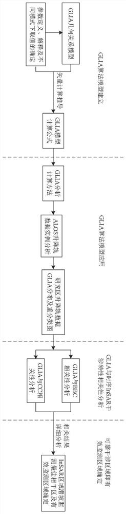
[0025] Such as Figure 1-7 As shown, the framework structure of the method process involved in the present invention is as attached figure 1 shown, including the following steps:

[0026] Step 1: Establish the response relationship between terrain and satellite attitude parameters, that is, the ground local angle of incidence (GLIA) algorithm model.

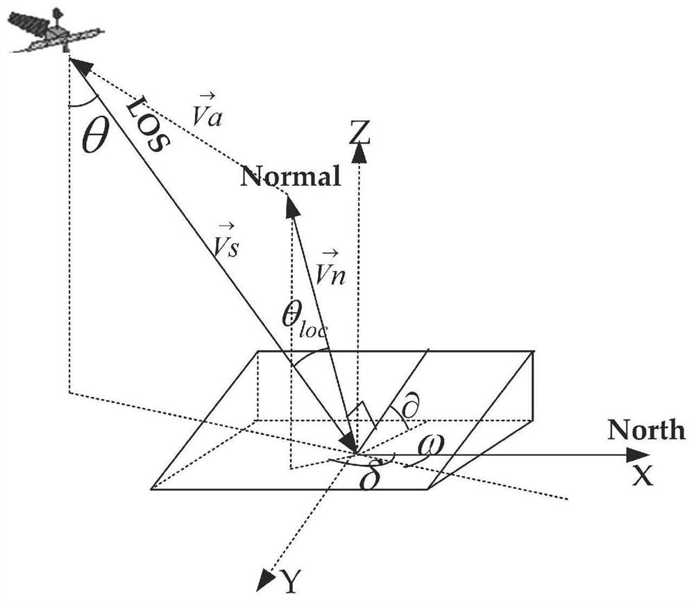
[0027] The local incidence angle on the ground is the angle between the incident direction of the radar electromagnetic wave and the normal direction of the ground point when the side-looking synthetic aperture radar is imaging the ground. and the slope and aspect of the ground imaging point, as attached figure 1 shown.

[0028] attached figure 2 Among them, θ is the incident angle of the satellite sensor, is the slope angle of the ground point, θ loc That is, the ground local incidence angle GLIA; δ ...


PUM


Abstract

The invention discloses an effective area determination method for early dynamic identification and monitoring of regional landslides based on InSAR technology. Aiming at the complex terrain characteristics and satellite side-view imaging characteristics of the landslide hazard disaster-forming environment, it accurately analyzes the terrain factor slope, slope aspect and satellite imaging incident angle. On the basis of the interaction relationship between attitude parameters such as , azimuth, etc., a comprehensive factor of the response relationship between terrain and satellite attitude parameters is proposed and established; and the local incident angle on the ground of each monitoring point on the ground is accurately calculated and simulated in the lifting orbit mode, and the impact on the ground Classify and analyze local incidence angles, analyze their mutual influence and change relationship with InSAR technology interference characteristics, and accurately determine effective monitoring areas and overlapping and shadow areas that cannot be effectively monitored, so as to realize side-view imaging of different complex terrain areas and different satellites The accurate determination of the effective monitoring range of regional landslide identification and monitoring under attitude parameters realizes the accurate analysis of early dynamic identification and monitoring of regional landslides with time-series InSAR technology.

Description

technical field [0001] The invention belongs to the technical field of early dynamic identification and monitoring of geological disasters by aerospace remote sensing, and solves the problem that the early dynamic identification and monitoring of regional landslides cannot be fully effective due to the influence of satellite attitude parameters and complex terrain factors when using Interferometric Synthetic Aperture Radar InSAR (Interferometric Synthetic Aperture Radar) technology. Coverage can not accurately determine which areas are effective monitoring areas, but through the establishment of relevant algorithm models to accurately calculate and determine the effective monitoring area method. Background technique [0002] In recent years, Interferometric Synthetic Aperture Radar (InSAR) technology has become an important means for the investigation and monitoring of large-scale and long-term series of surface deformation disasters, and has also been widely used in landslid...

Claims


Application Information

Patent Timeline
Patent Type & Authority Patents(China)
IPC IPC(8): G06K9/00G01S13/90
CPCG01S13/9023G06V20/13
Inventor 王桂杰吴维伦叶圣生胡洪涛郭海朋王云龙臧西胜秦同春朱菊艳王海刚
Owner 中国地质环境监测院
Why Eureka
Try Eureka