Method for instant positioning and map building based on fusion of laser and two-dimensional code

A map construction and two-dimensional code technology, which is applied in surveying and navigation, measuring devices, instruments, etc., can solve the problems of single application, positioning failure, and inability to meet the application requirements of complex environments.

Active Publication Date: 2019-01-15
BEIJING INSTITUTE OF TECHNOLOGYGY
View PDF6 Cites 35 Cited by
  • Summary
  • Abstract
  • Description
  • Claims
  • Application Information

AI Technical Summary

Problems solved by technology

[0003] In the prior art, there are mainly large-scale forklift handling AGVs combined with laser real-time positioning, map construction and inertial devices, and logistics robots that integrate visual sensors and inertial devices; among them, large-scale forklift handling AGVs use laser real-time positioning and map construction (SLAM, Simultaneous Localization And Mapping) for map construction and inertial device assisted positioning to complete the navigation task. Although the accuracy of navigation is effectively guaranteed, the application of this navigation technology in open or turning situations is likely to cause positioning failure; logistics robots only recognize QR code labels Complete positioning and navigation. Although the simple algorithm ensures the positioning effect of the logistics robot when it is running at high speed, the application is single and cannot meet the application requirements of complex environments.

Method used


Image

  • Method for instant positioning and map building based on fusion of laser and two-dimensional code
  • Method for instant positioning and map building based on fusion of laser and two-dimensional code
  • Method for instant positioning and map building based on fusion of laser and two-dimensional code

Examples


Embodiment Construction

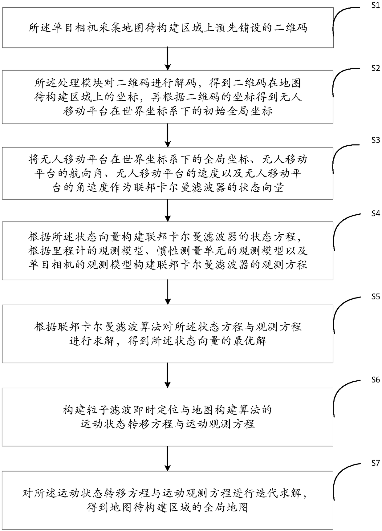
[0057] In order to enable those skilled in the art to better understand the solutions of the present application, the technical solutions in the embodiments of the present application will be clearly and completely described below in conjunction with the drawings in the embodiments of the present application.

[0058] see figure 1 , which is a flowchart of a real-time location and map construction method based on laser and two-dimensional code fusion provided in this embodiment.

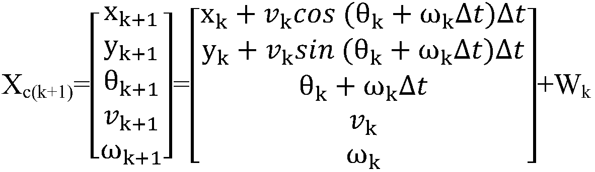
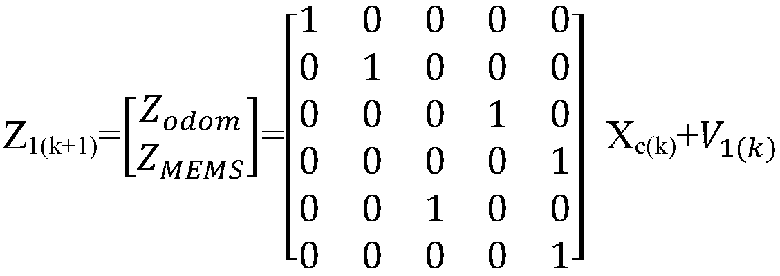
[0059] An instant positioning and map construction method based on laser and two-dimensional code fusion is applied to an unmanned mobile platform, and the unmanned mobile platform includes a processing module, a monocular camera, a laser radar, an odometer, and an inertial measurement unit.

[0060] Optionally, the monocular camera and lidar are installed on the front of the unmanned mobile platform, the odometer is installed on the wheels of the unmanned mobile platform, and the inertial measuremen...


PUM


Abstract

The invention provides a method for the instant positioning and the map building based on the fusion of a laser and a two-dimensional code. The driving distance and the speed information of an odometer, a two-dimensional code acquired by a monocular camera, and the information of an inertial measurement unit are integrated into a state vector. An observation equation of the federated Kalman filteris constructed according to an observation model of the odometer, an observation model of the inertial measurement unit, and an observation model of the monocular camera. The two-dimensional code positioning information is added on the basis of a traditional odometer and the inertial measurement unit, thereby obtaining the optimal solution of the state vector of an unmanned mobile platform; the pose prediction information with higher accuracy is formed by using the characteristics of the fastness and the accuracy of the two-dimensional code information processing, thereby reducing the numberof particles in the method for particle filter instant positioning and map building, and improving the low-power processor, such as the positioning accuracy of the unmanned mobile platform. The positioning effect of the unmanned mobile platform in the complex environment is ensured, map building is completed, and the application need in the complex environment is met.

Description

technical field [0001] The invention belongs to the technical field of instant positioning and map construction, and in particular relates to an instant positioning and map construction method based on laser and two-dimensional code fusion. Background technique [0002] Unmanned mobile platforms, such as automated guided vehicles (AGV, Automated Guided Vehicle), have been widely used in many industries, and their application environments have gradually become more complex, showing that various scenarios may appear within the same navigation range , such as: a large range of open roads, complex arrangements of cargo racks, etc. At the same time, in practical applications, high-speed industrial automatic guided transport vehicles are often equipped with low-power processors. Therefore, it is the key to the wide application of automatic guided transport vehicles to propose appropriate navigation technology according to the actual application requirements of automatic guided tr...

Claims


Application Information

Patent Timeline
Patent Type & Authority Applications(China)
IPC IPC(8): G01C21/32G01C21/34
CPCG01C21/32G01C21/343G01C21/3446
Inventor 肖烜覃梓雨王晨刘康妮刘俐伶
Owner BEIJING INSTITUTE OF TECHNOLOGYGY
Why Eureka
Try Eureka