Low-cost multipoint safe and high-precision positioning monitoring method and system

A low-cost, high-precision technology, used in satellite radio beacon positioning systems, altitude/level measurement, radio wave measurement systems, etc., can solve problems such as poor expansion of remote monitoring systems and high-precision positioning receivers. The effect of preventing interception and malicious tampering of data, good interaction function, strong flexibility and adaptability

Pending Publication Date: 2019-02-05
NANJING UNIV
View PDF5 Cites 14 Cited by
  • Summary
  • Abstract
  • Description
  • Claims
  • Application Information

AI Technical Summary

Problems solved by technology

[0010] The purpose of the present invention is to disclose a set of low-cost multi-point safe high-precision positioning monitoring method and system, which can realize from A complete set of functions for satellite raw data acquisition at the data receiving end, data baseline calculation, data encryption and forwarding to the client graphical interface to display monitoring data and control

Method used


Image

  • Low-cost multipoint safe and high-precision positioning monitoring method and system
  • Low-cost multipoint safe and high-precision positioning monitoring method and system
  • Low-cost multipoint safe and high-precision positioning monitoring method and system

Examples


Embodiment Construction

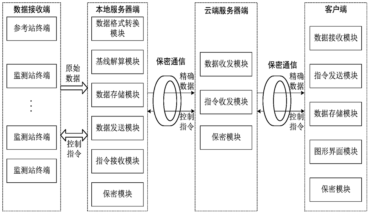
[0025] The composition of each part of the present invention is specifically as follows: (1) data receiving end

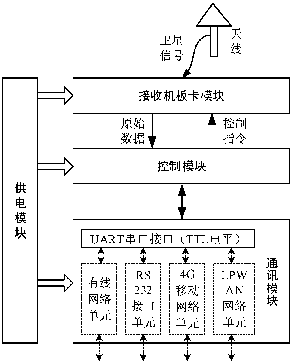
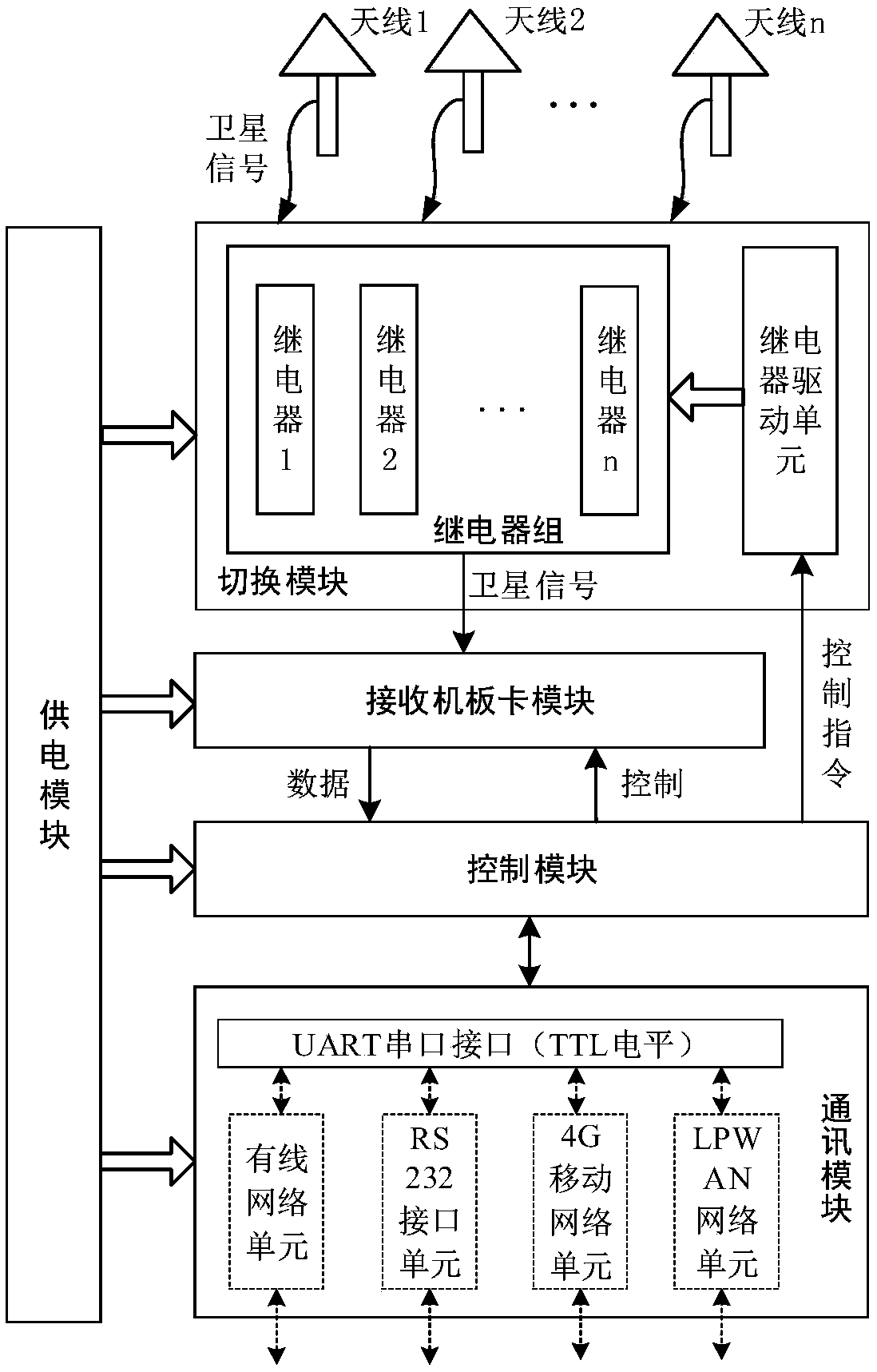
[0026] The main part of the data receiving end is the satellite receiving terminal. According to different functions, it is necessary to set up a reference station terminal and a monitoring station receiving terminal. The satellite receiving terminal is mainly responsible for receiving the radio frequency satellite signal sent by the satellite and performing preliminary processing of the satellite signal to obtain the original data and send it to the local server. The reference station terminal is composed of a power supply module, GNSS board module, control module and communication module; the monitoring station receiving terminal is composed of a power supply module, a multi-choice switching module, a GNSS board module, a control module and a communication module.

[0027] (a) Reference station terminal

[0028] The reference station terminal at the data receivi...


PUM


Abstract

The invention relates to a low-cost multipoint safe and high-precision positioning monitoring system. The low-cost multipoint safe and high-precision positioning monitoring system is composed of foursubsystems of a data receiving end, a local server end, a cloud server end and a client end. At the data receiving end, satellite original data of a satellite reference station and a satellite monitoring station are separately obtained, and the satellite original data are sent to the local server end. The satellite monitoring station can obtain coordinate data of multiple point antennas by selecting one module more than once in a time sharing mode, so that the monitoring function of a GNSS board for multiple points is achieved. In the later stage, new monitoring stations or antennas can be added as required, so that intervisibility is not required between the monitoring stations, and the monitoring stations do not influence each other. Four ways is adopted in the data receiving end to sendthe data to the local server end. The local server is responsible for data format conversion, baseline calculation, data storage on original data, and the data are transmitted to the cloud server end. The cloud server end is responsible for data and instruction interaction between the local server end and the client end.

Description

technical field [0001] The invention discloses a method and system for low-cost multi-point safe high-precision positioning monitoring, especially realizes the functions of receiving and forwarding original data, calculating high-precision baseline, encrypting data transmission, and displaying and controlling the graphical interface of the client , mainly used in the fields of satellite positioning and settlement monitoring. Background technique [0002] GNSS (Global Navigation Satellite System, GNSS) has a faster positioning speed, and can be monitored automatically around the clock, and its effect is far superior to the traditional manual measurement method using optical instruments. Monitoring geological subsidence is advanced and feasible. A satellite navigation system is a system that uses satellites to achieve its own geospatial positioning. It allows a small electronic receiver to determine its position (including longitude, latitude and altitude) by receiving high-...

Claims


Application Information

Patent Timeline
Patent Type & Authority Applications(China)
IPC IPC(8): G01S19/14G01C5/00H04L29/06H04L29/08
CPCH04L63/0428H04L67/10G01C5/00G01S19/14
Inventor 王健朱鹏陈原查日苏陈宇涛
Owner NANJING UNIV
Why Eureka
Try Eureka