Downscaling correction method of precipitation data of mountain satellite

A correction method and downscaling technology, applied in the downscaling correction of satellite precipitation data and the downscaling correction of satellite precipitation data in mountainous areas, can solve problems such as lack and achieve the effect of ensuring stability

Active Publication Date: 2019-02-22
CHINA INST OF WATER RESOURCES & HYDROPOWER RES
View PDF5 Cites 12 Cited by
  • Summary
  • Abstract
  • Description
  • Claims
  • Application Information

AI Technical Summary

Problems solved by technology

[0005] The technical problem to be solved by the present invention is to overcome the shortcomings of existing satellite precipitation data downscaling correction methods in the application of high-altitude...

Method used


Image

  • Downscaling correction method of precipitation data of mountain satellite
  • Downscaling correction method of precipitation data of mountain satellite
  • Downscaling correction method of precipitation data of mountain satellite

Examples


Embodiment Construction

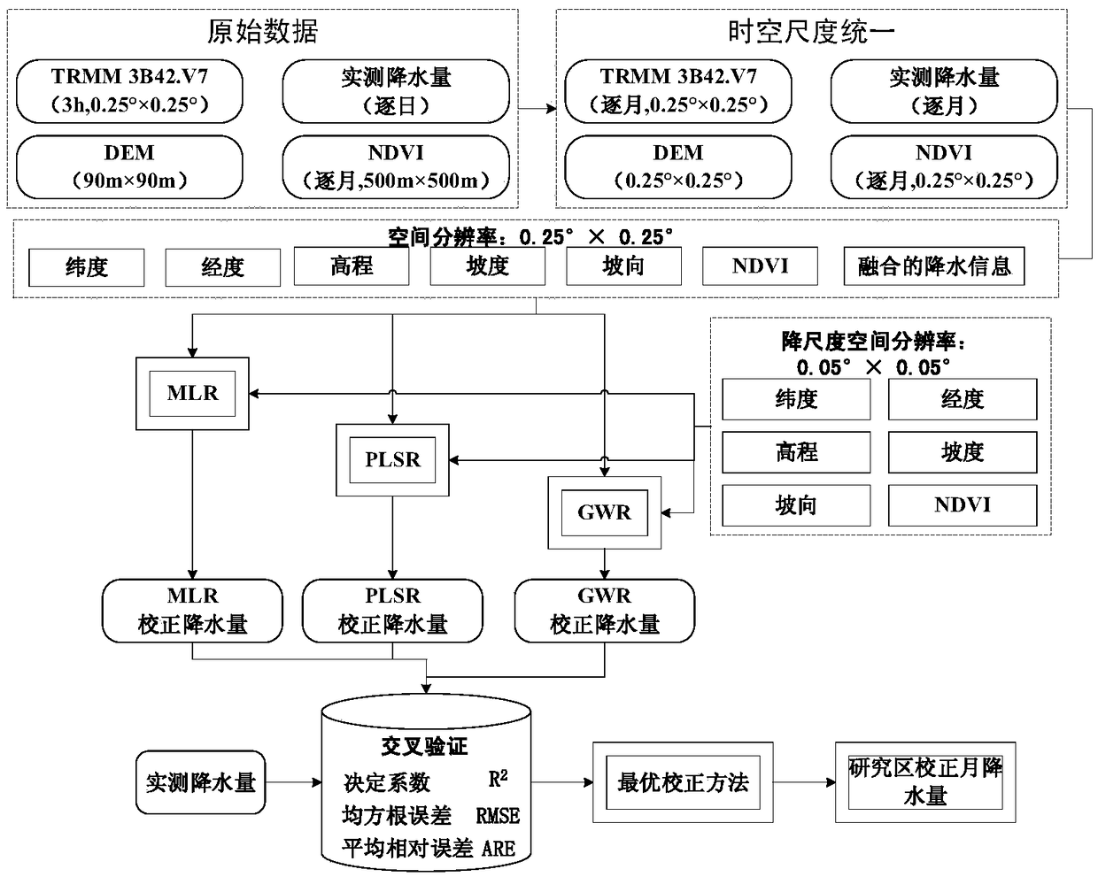
[0081] Below in conjunction with accompanying drawing and specific embodiment, the present invention is described in further detail:

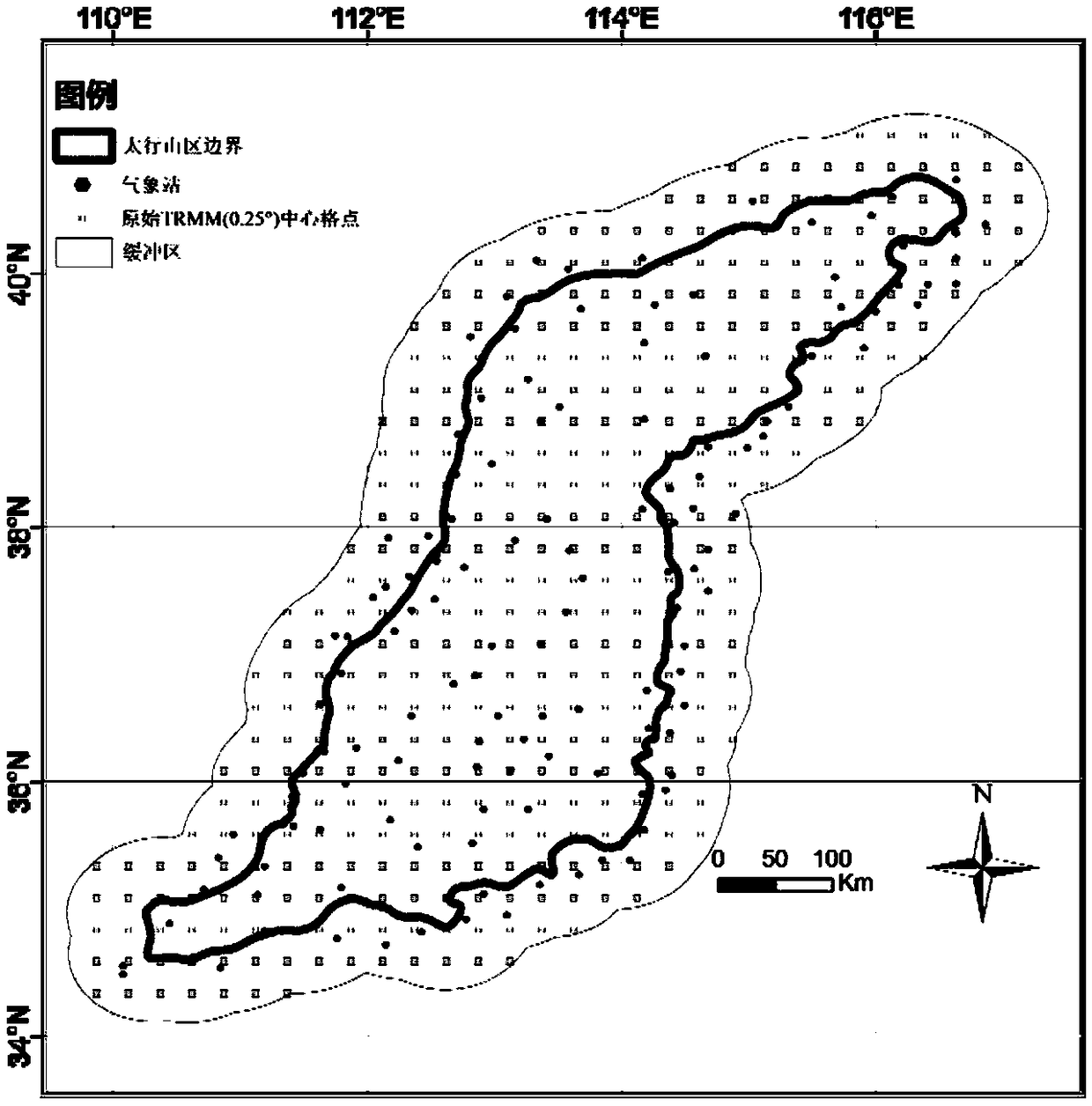
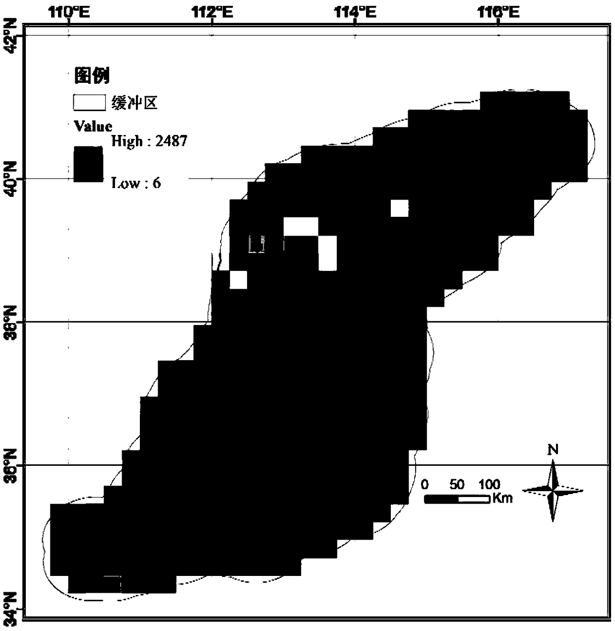
[0082] The Taihang Mountains start from the Xishan Mountain in Beijing in the north, extend southward to Wangwu Mountain in the border area of ​​Shanxi and Henan, border the Shanxi Plateau in the west, and border the North China Plain in the east, extending from northeast to southwest for more than 400 kilometers. . The present invention selects the Taihang Mountains as the research area. The overview of the research area is as follows: the total area is about 127,800 km 2 , with an altitude range of -65 to 3059m, across the four provinces (cities) of Beijing, Hebei, Shanxi and Henan, and across the two primary river basins of the Haihe River and the Yellow River; Coniferous shrub forest, coniferous and broad-leaved mixed forest, deciduous broad-leaved forest, artificial forest, deciduous shrub and grass slope and other vegetation types; it b...


PUM


Abstract

The invention discloses a downscaling correction method of precipitation data of a mountain satellite. The method comprises the following steps: reading of TRMM 3B42.V7 satellite precipitation data and carrying out monthly precipitation statistics; carrying out correcting variable fusion and spatial scale unification; establishing a regression downscaling model; and carrying out cross validation and downscaling correction execution. According to the invention, the observation precipitation data of the mountain meteorological station are fused into the downscaling correction process of the satellite precipitation data and the method optimization is carried out by using the cross-validation technology, so that advantages of the limited observation data in the mountain area are fully utilized, the precision of the precipitation after the down-scaling correction and consistency with the measured data series are greatly improved. In addition, the invention also puts forward a multi-method comparison reviewing type downscaling correction technique, so that a system deviation problem of the single downscaling correction method is solved, the satellite precipitation data downscaling correction method system is enriched, and the credibility of the results is enhanced. According to the method, the adaptability to the downscaling correction of typical mountain satellite precipitation products is enhanced; and related results can provide strong support for the system to grasp the temporal and spatial distribution characteristics of precipitation in mountainous areas.

Description

technical field [0001] The invention relates to the technical field of water conservancy engineering, in particular to a method for downscaling correction of satellite precipitation data, in particular to a method for downscaling correction of satellite precipitation data in mountainous areas. Background technique [0002] As the total input of the water cycle process, precipitation is one of the most important and active elements in the water cycle process, and plays an important role in material movement and energy exchange. Accurate estimation of precipitation is crucial for accurate analysis of water cycle process and scientific decision-making of water-related affairs. Affected by many factors such as the direction of the mountains, the slope of the terrain, and the source of water vapor, the mountain water cycle has a vertical zonality. However, the existing ground observation stations are unevenly distributed, and most of them are located in low-altitude areas. In hi...

Claims


Application Information

Patent Timeline
IPC IPC(8): G01W1/18G01W1/10
CPCG01W1/10G01W1/18
Inventor 杜军凯李晓星刘欢贾仰文牛存稳仇亚琴郝春沣赵红莉冶运涛张海涛张双虎郑钊
Owner CHINA INST OF WATER RESOURCES & HYDROPOWER RES
Why Eureka
Try Eureka