
A method for extracting the layered structure and spatial distribution of sedimentary layers in a local sea area

A technology of layered structure and spatial distribution, applied in the fields of ocean survey and seafloor remote sensing, which can solve the problems of accuracy of manual processing of shallow profile data and so on.

Active Publication Date: 2019-03-05
INST OF ACOUSTICS CHINESE ACAD OF SCI
View PDF4 Cites 4 Cited by
  • Summary
  • Abstract
  • Description
  • Claims
  • Application Information

AI Technical Summary

Problems solved by technology

This method can effectively remove the interference of ship noise and wake on the sea surface, and avoid the influence of multiple reflection echoes on the sea bottom. In the data of sea bottom reverberation interference, the accurate spatial layered interface structure of the sediment layer in the local sea area can be obtained synchronously and continuously. Furthermore, the number of layers of the sedimentary layer and the position and thickness of each layer can be automatically obtained, which solves the problem of manual processing and low accuracy of shallow profile data in the multi-system joint seabed survey

Method used


Image

  • A method for extracting the layered structure and spatial distribution of sedimentary layers in a local sea area
  • A method for extracting the layered structure and spatial distribution of sedimentary layers in a local sea area
  • A method for extracting the layered structure and spatial distribution of sedimentary layers in a local sea area

Examples


Embodiment Construction

[0074] The present invention will be further described in detail below in conjunction with the accompanying drawings.

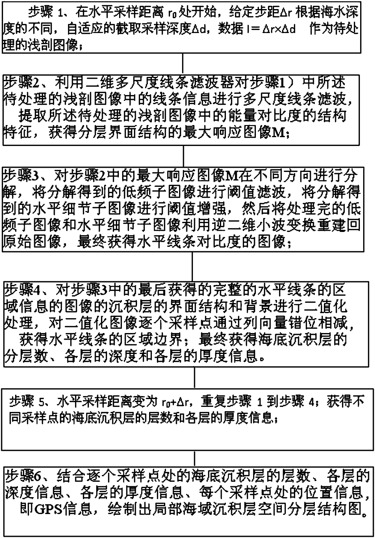
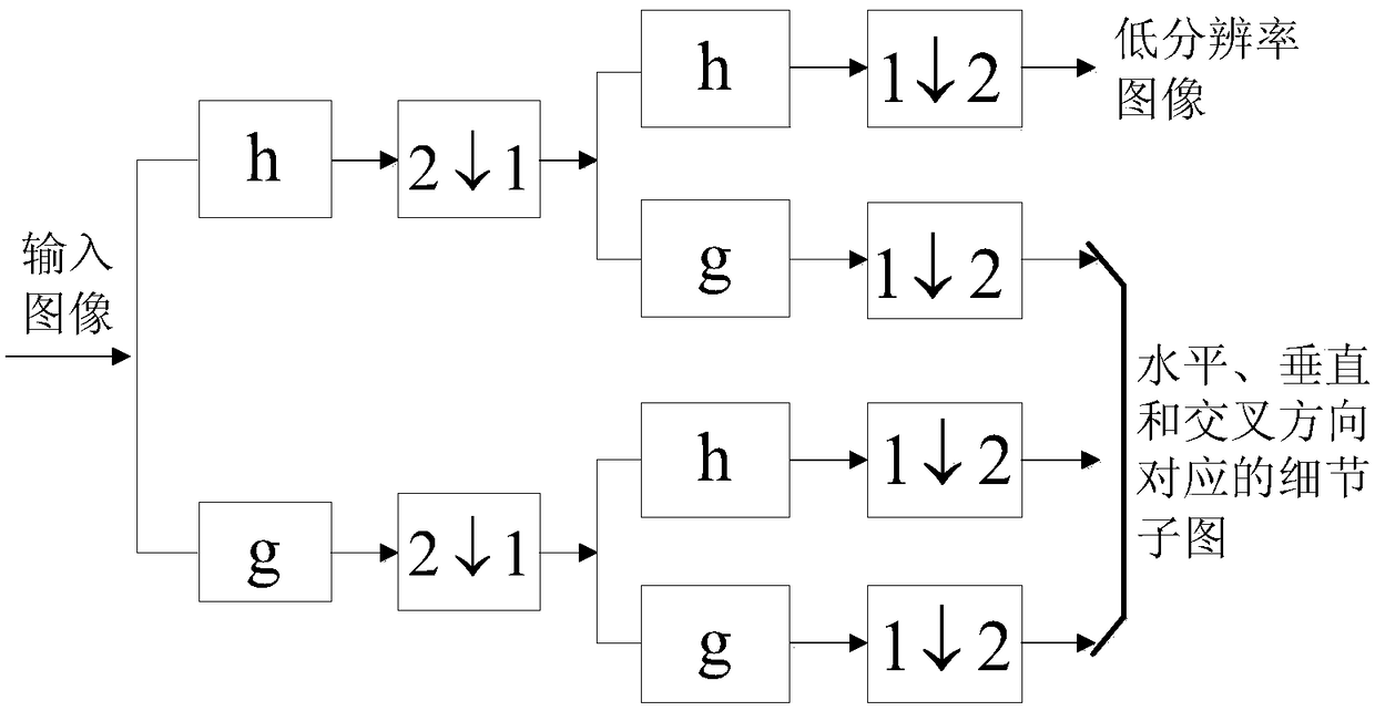
[0075] The method of the invention provides the technical flow of regional shallow section data processing, and the specific implementation steps of obtaining the layered information of the sediment layer in the local sea area. In addition, the method of the present invention increases the comprehensive processing of the shallow section data of the last area, and provides two image representation methods of the layered structure information of the sediment layer in the local sea area. In addition, the method of the present invention adds threshold filtering in low-frequency detail sub-images and threshold enhancement in horizontal detail sub-images after using two-dimensional wavelet transform to decompose the superficial section image processed by multi-scale filtering, and then uses inverse two The low-frequency detail sub-image processed by threshold filte...


PUM


Abstract

The invention provides a method for extracting the layered structure and spatial distribution of a sediment layer in a local sea area, comprising the following steps of 1 taking the data i= delta r*delta d as a shallow section image to be processed; 2 utilizing a two-dimensional multi-scale line filter to carry out multi-scale line filter on that line information in the shallow section image to beprocessed to obtain the maximum response image M; 3 decomposing that maximum response image M in different directions, performing threshold filtering on the decomposed low-frequency sub-image, performing threshold enhancement on the decomposed horizontal detail sub-image, reconstructing the original image by using an inverse two-dimensional wavelet transform, and obtaining an image of horizontalline contrast; 4 binarizing the interface structure and background of the deposited layer of the image of the area information of the horizontal line in the step 3 to obtain the area boundary of the horizontal line; 5 defining the horizontal sample distance to be r0 + delta r, and repeating the steps 1 to 4; 6 drawing a spatial layering structure map of a sediment lay in a local sea area.

Description

technical field [0001] The invention relates to the technical fields of oceanographic measurement and seabed remote sensing, in particular to a method for extracting the layered structure and spatial distribution of sedimentary layers in local sea areas. Background technique [0002] Obtaining accurate marine environmental information is the foundation of marine resource development and national defense construction, and the spatial layered structure and spatial distribution of seabed sediments in local sea areas are important conditions for the study of seabed geological changes and the application of sonar equipment. The traditional method of extracting the layered structure and spatial distribution of seabed sediments is to use columnar sampling equipment, use mechanical pressure or gravity to sample at fixed points, and analyze the sediment in the laboratory to obtain the parameter information of the sedimentary layer, and then obtain the stratification of the sedimentary...

Claims


Application Information

Patent Timeline
Patent Type & Authority Applications(China)
IPC IPC(8): G06T5/00G06T11/20
CPCG06T11/206G06T5/90G06T5/70
Inventor 任群言王文博李军马力
Owner INST OF ACOUSTICS CHINESE ACAD OF SCI
Learn More