Urban terrain three-dimensional reconstruction method based on four-rotor unmanned aerial vehicle laser radar system

A four-rotor UAV and three-dimensional reconstruction technology, which is applied in radio wave measurement system, satellite radio beacon positioning system, electromagnetic wave reradiation, etc., can solve the problem of low automatic modeling ratio, low efficiency, model voids and distortions, etc. question

Active Publication Date: 2019-03-12
HEFEI INSTITUTES OF PHYSICAL SCIENCE - CHINESE ACAD OF SCI
View PDF21 Cites 5 Cited by
  • Summary
  • Abstract
  • Description
  • Claims
  • Application Information

AI Technical Summary

Problems solved by technology

At present, UAV Lidar surveying and mapping generally uses the method of ground target positioning and ground base station cooperation, but the adaptability to different landforms is not strong, and artificial exploration is required in advance to set up targets around the surveying and mapping site. The process is cumbersome and inefficient.
The point cloud data obtained at the same time needs to be processed offline at the base station, and the real-time performance is not good enough
[0003] In recent years, with the development of computer vision and the enhancement of graphics computing capabilities, there have also been technologies that rely on sequential images to recover structures from motion to perform 3D modeling of urban terrain, but the accuracy of modeling by taking pictures is not high enough , prone to model voids and distortions, adjustments after modeling rely on human participation, manual editing and optimization
The model is not accurate enough, and it is easy to mix human subjective factors
The 3D map functions of maps such as Baidu Map also rely on manual modeling, and the proportion of automated modeling is relatively low

Method used


Image

  • Urban terrain three-dimensional reconstruction method based on four-rotor unmanned aerial vehicle laser radar system
  • Urban terrain three-dimensional reconstruction method based on four-rotor unmanned aerial vehicle laser radar system
  • Urban terrain three-dimensional reconstruction method based on four-rotor unmanned aerial vehicle laser radar system

Examples


Embodiment Construction

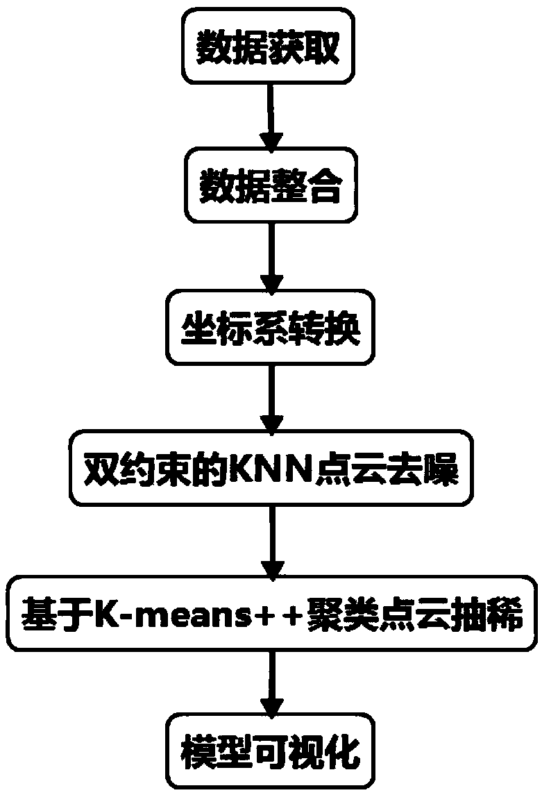
[0052] In this example, if figure 1 As shown, a 3D reconstruction method of urban terrain based on the quadrotor UAV lidar system is carried out as follows:

[0053] Step 1. Data acquisition:

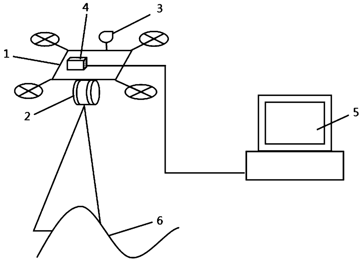
[0054] Step 1.1. Use the airborne GPS on the quadrotor UAV to obtain its own positioning information set in RMC format in real time and send it to the ground base station frame by frame in order for storage. Any αth positioning information includes: αth GPS time stamp RMC α .timestamp, αth longitude and latitude RMC α .position, the αth heading information RMC α .track;

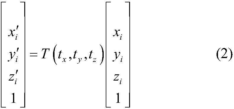
[0055] Step 1.2. Use the airborne lidar on the quadrotor UAV to obtain the urban terrain data set D and send it to the ground base station frame by frame in order for storage. Any jth urban terrain data d j Contains: the jth dot d j .PointID, the jth space coordinate point (x j ,y j ,z j ), the jth adjustment time d j .adjustedtime, the jth azimuth d j .Azimuth, jth distance d j .Distance, the jth reflectio...


PUM


Abstract

The invention discloses an urban terrain three-dimensional reconstruction method based on a four-rotor unmanned aerial vehicle laser radar system, which comprises the following steps: 1, acquiring data; 2, integrating data; 3, converting the coordinate system; 4, point cloud denoising; 5, vacuating point cloud; 6, model visualizing. The method can achieve real-time automatic earth surface three-dimensional reconstruction, does not need manual participation, has higher precision and faster speed than traditional image three-dimensional reconstruction methods such as structure recovery from motion and the like, and can be used for various types of low-cost rapid earth surface three-dimensional reconstruction.

Description

technical field [0001] The invention relates to the field of machine vision, specifically a method for three-dimensional reconstruction of urban terrain based on a quadrotor UAV LiDAR system. Background technique [0002] With the development of drone technology, the price of consumer-grade drones continues to drop, and the miniaturization and portability of lidar, it is possible for small and medium-sized drones to carry lidar for geographic surveying and mapping. At present, UAV Lidar surveying and mapping generally uses the method of ground target positioning and ground base station cooperation, but the adaptability to different landforms is not strong, and manual exploration is required in advance to set up targets around the surveying and mapping site. The process is cumbersome and inefficient. The point cloud data obtained at the same time needs to be processed offline at the base station, and the real-time performance is not good enough. [0003] In recent years, wit...

Claims


Application Information

Patent Timeline
Patent Type & Authority Applications(China)
IPC IPC(8): G01S17/89G01S19/42G01S7/48
CPCG01S7/4802G01S17/89G01S19/42
Inventor 吴晶华王子建王容川叶晓东孔令成曾伟张萍宋戈梁伟
Owner HEFEI INSTITUTES OF PHYSICAL SCIENCE - CHINESE ACAD OF SCI
Why Eureka
Try Eureka