
InSAR image processing method and device based on deep learning algorithm

A deep learning and image technology, applied in the field of radar, can solve the problems of poor data coherence in the vegetation coverage area, limited interferometric measurement accuracy, affecting the performance of interferometric processing, etc., and achieve the effect of reducing vegetation coverage.

Active Publication Date: 2019-03-29
CHINA ACADEMY OF ELECTRONICS & INFORMATION TECH OF CETC
View PDF6 Cites 12 Cited by
  • Summary
  • Abstract
  • Description
  • Claims
  • Application Information

AI Technical Summary

Problems solved by technology

[0007] (1) Difficulties in interference processing and accurate elevation information inversion in alpine and urban areas
In the case of severe surface deformation, overlapping and shadowing in high mountainous areas and urban areas, undersampling of the interferometric phase and lack of interferometric information are prone to occur, resulting in difficult interferometric processing, poor solvability, and low accuracy of elevation measurement.
[0008] (2) The coherence of vegetation coverage area data is poor, and the efficiency of interference processing is low
In vegetation-covered areas, especially in dense forest areas and crop planting areas that grow vigorously in summer, the coherence of interferometric data acquired by repeated orbit mode is very low, the solvability of phase unwrapping is poor, and the accuracy of elevation measurement is low, which seriously affects the interferometric data. processing performance
[0009] (3) Large area InSAR processing requires a large number of ground control points
For areas where it is difficult to deploy control points such as mountains and valleys or overseas areas, due to the lack of ground control points, the accuracy of interferometric measurements is limited
[0010] (4) Changes in the atmosphere, ionosphere, and soil moisture will cause large changes in the interferometric phase value, which will seriously affect the interferometric accuracy measurement

Method used


Image

  • InSAR image processing method and device based on deep learning algorithm
  • InSAR image processing method and device based on deep learning algorithm

Examples


Embodiment Construction

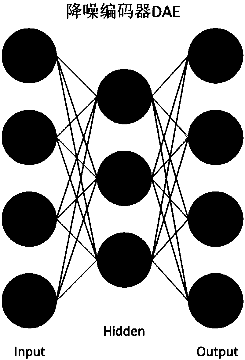
[0042] In order to solve the problem that InSAR images are greatly affected by changes in vegetation, atmosphere, and ionosphere, and to obtain clearer and more accurate InSAR images, it is necessary to study the correspondence between InSAR images and meteorological environmental factors and the corresponding processing methods. Noisy Encoder DAE (such as figure 1 shown), for automatic processing of InSAR images. The embodiment of the present invention starts with technologies such as InSAR image processing and deep learning, and solves the problem that the InSAR image is affected by the meteorological environment, thereby reducing the measurement accuracy.

[0043] Exemplary embodiments of the present disclosure will be described in more detail below with reference to the accompanying drawings. Although exemplary embodiments of the present disclosure are shown in the drawings, it should be understood that the present disclosure may be embodied in various forms and should no...


PUM


Abstract

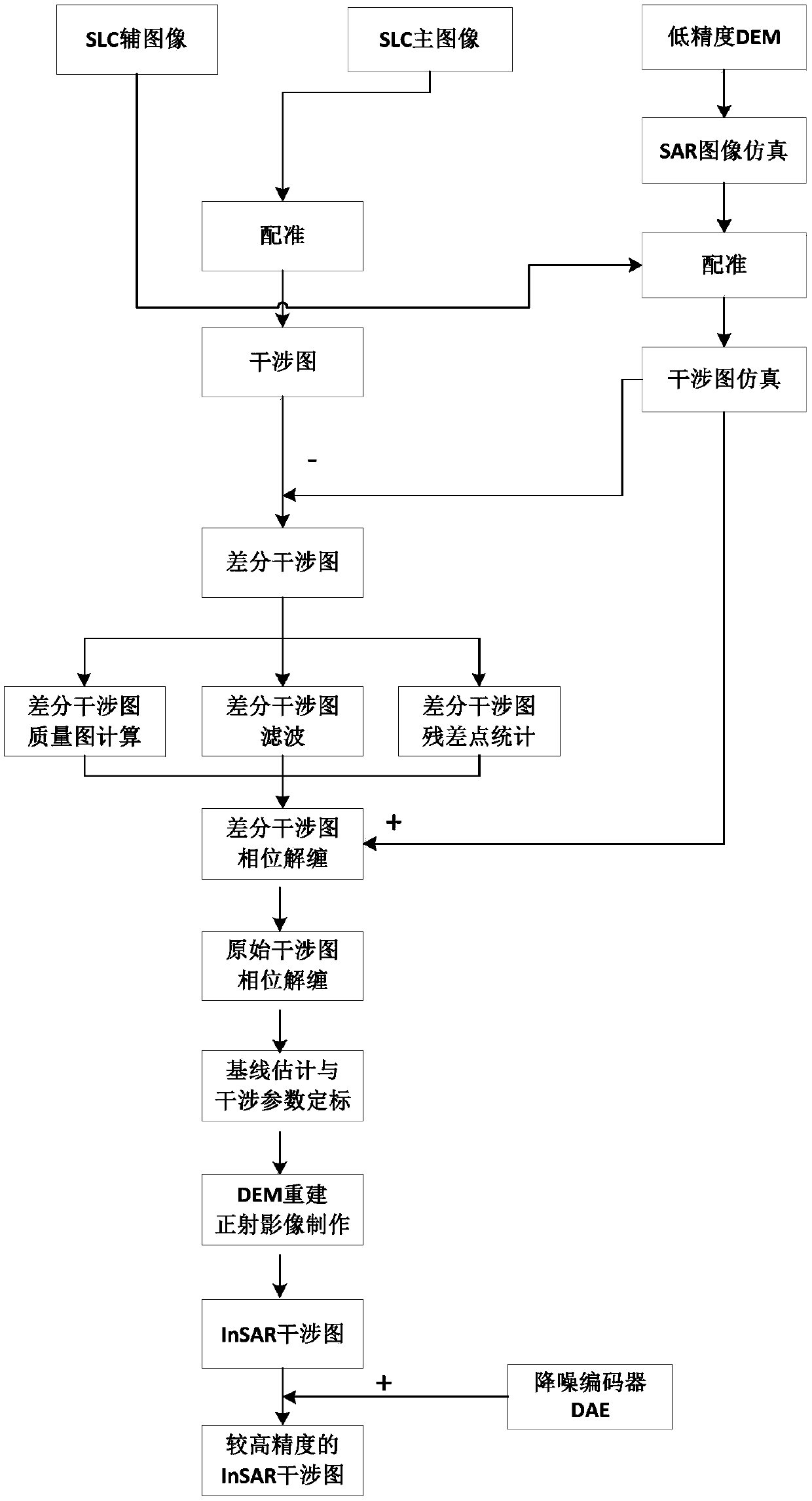
The invention discloses an InSAR image processing method and device based on a deep learning algorithm. The method comprises: using a low-precision digital elevation model (DEM) to simulate a synthetic aperture radar SAR image, registering the simulated SAR image with an actual SAR image, and establishing a correspondence between the low-precision DEM and the actual SAR image; performing interferogram simulation by utilizing a low-precision DEM based on the corresponding relation, and dividing the actually acquired interferogram from the simulated interferogram to obtain a differential interferogram; processing the differential interferogram, performing phase unwrapping on the differential interferogram according to the simulated interferogram, obtaining the original interferogram, and performing phase unwrapping thereon; performing baseline estimation and interference parameter calibration, reconstructing the DEM, and performing orthophoto production through the reconstructed DEM to obtain an InSAR interferogram; using the depth learning algorithm to train a noise reduction encoder DAE, and performing noise reduction processing on the InSAR interferogram to obtain a high-precisionInSAR image.

Description

technical field [0001] The present invention relates to the field of radar technology, in particular to an InSAR image processing method and device based on a deep learning algorithm. Background technique [0002] With the rapid development of radar technology in our country, Interferometric Synthetic Aperture Radar (InSAR) technology is also developing rapidly, which has outstanding advantages in rapid terrain mapping. Synthetic aperture radar interferometry technology is a high-precision earth observation technology developed rapidly with the development of information technology, photogrammetry technology, digital signal processing technology and other related technologies. It has all-time, all-weather, high-precision, high-efficiency, large-area and other outstanding advantages in topographic mapping, surface deformation monitoring, and glacier movement research. [0003] Using InSAR technology to quickly obtain high-precision digital elevation model (Digital Elevation ...

Claims


Application Information

Patent Timeline
IPC IPC(8): G01S13/90
CPCG01S13/90G01S13/9023G01S7/417
Inventor 姜雅文张博汪溁鹤毕严先袁苏文谷晓鹏
Owner CHINA ACADEMY OF ELECTRONICS & INFORMATION TECH OF CETC
Learn More