
Method for positioning vertical direction of object by utilizing inertial navigation system

An inertial navigation system and vertical direction technology, which is applied in the field of using inertial navigation system to locate objects in the vertical direction, can solve the problems of inability to measure measurement errors, and the height of measurement objects is easily affected by the environment, and achieves the effect of high measurement accuracy.

Active Publication Date: 2019-04-26
NANJING CHUHANG TECH CO LTD
View PDF7 Cites 2 Cited by
  • Summary
  • Abstract
  • Description
  • Claims
  • Application Information

AI Technical Summary

Problems solved by technology

[0015] A method for positioning an object in the vertical direction using an inertial navigation system proposed by the present invention can solve the technical problem that the existing technology for measuring the height of an object is easily affected by the environment and cannot be measured or has a large measurement error

Method used


Image

  • Method for positioning vertical direction of object by utilizing inertial navigation system
  • Method for positioning vertical direction of object by utilizing inertial navigation system
  • Method for positioning vertical direction of object by utilizing inertial navigation system

Examples


Embodiment Construction

[0066] In order to make the purpose, technical solutions and advantages of the embodiments of the present invention clearer, the technical solutions in the embodiments of the present invention will be clearly and completely described below in conjunction with the drawings in the embodiments of the present invention. Obviously, the described embodiments It is a part of embodiments of the present invention, but not all embodiments.

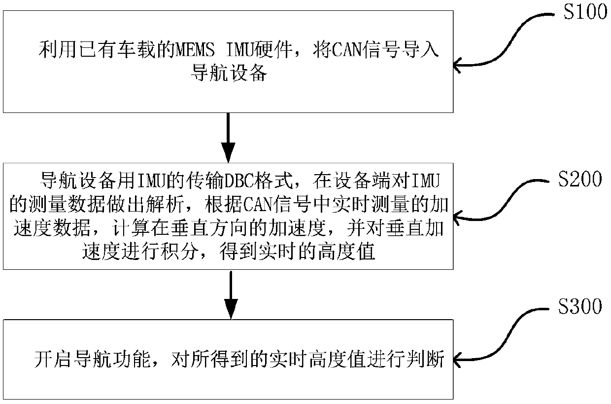
[0067] Such as figure 1 As shown, the method for positioning an object in the vertical direction using an inertial navigation system described in this embodiment includes the following steps:

[0068] S100, using the existing MEMS IMU hardware on the vehicle to import the CAN signal into the navigation device;

[0069] S200. The navigation device uses the transmission DBC format of the IMU, analyzes the measurement data of the IMU at the device end, calculates the acceleration in the vertical direction according to the acceleration data measured in...


PUM


Abstract

The invention provides a method for positioning vertical direction of object by utilizing an inertial navigation system. The technical problem can be solved that an existing object height measuring technology is easily affected by the environment and accordingly measurement cannot be achieved or measurement errors are larger. The method comprises the following steps: S100, utilizing existing vehicle-mounted MEMS IMU hardware to import a CAN signal into a navigation device; S200, in the transmission DBC format of an IMU arranged for the navigation device, resolving the measurement data of the IMU at the device side, according to the real-time measured acceleration data in the CAN signal, calculating the acceleration in the vertical direction and integrating the vertical acceleration to obtain a real-time height value; S300, enabling a navigation function, and judging the obtained real-time height value. The method utilizes a vehicle or an instrument equipped with an inertial navigationsystem to acquire the change of an object at the height, accordingly obtains the relative height of the object, is not affected by the environment and is high in measurement precision.

Description

technical field [0001] The invention relates to the technical field of object height measurement, in particular to a method for positioning an object in the vertical direction by using an inertial navigation system. Background technique [0002] At present, the height measurement of objects generally adopts the following measurement methods: [0003] 1. Air pressure altitude sensor [0004] The barometric altitude sensor is a sensor that uses changes in air pressure to measure altitude. When measuring the height, because the processor needs to be used to calculate the height value through the formula, it is mainly used in the floor positioning of aircraft model products, GPS altimetry, outdoor mountaineering watches, outdoor mountaineering mobile phones, hunting cameras and other parachute meteorological equipment. [0005] 2. Satellite positioning measurement [0006] The principle of GPS positioning is to judge the relative position between the receiver and the satellit...

Claims


Application Information

Patent Timeline
Patent Type & Authority Applications(China)
IPC IPC(8): G01C21/16G01C5/00
CPCG01C5/00G01C21/16
Inventor 楚詠炎李烜张我弓
Owner NANJING CHUHANG TECH CO LTD
Learn More