progressive encryption triangulation network LiDAR point cloud filtering method under the assistance of waveform information

A technology of waveform information and triangulation, which is applied in the field of remote sensing, can solve problems such as undeveloped research, and achieve the effects of improving reliability, improving accuracy, and high accuracy and reliability

Inactive Publication Date: 2019-06-11
INST OF REMOTE SENSING & DIGITAL EARTH CHINESE ACADEMY OF SCI
View PDF3 Cites 2 Cited by
  • Summary
  • Abstract
  • Description
  • Claims
  • Application Information

AI Technical Summary

Problems solved by technology

Therefore, using waveform information to assist lidar point cloud data processing will have important theoretical significance and practical application value, but such research has not yet been carried out

Method used


Image

  • progressive encryption triangulation network LiDAR point cloud filtering method under the assistance of waveform information
  • progressive encryption triangulation network LiDAR point cloud filtering method under the assistance of waveform information
  • progressive encryption triangulation network LiDAR point cloud filtering method under the assistance of waveform information

Examples


Embodiment

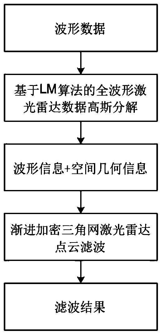
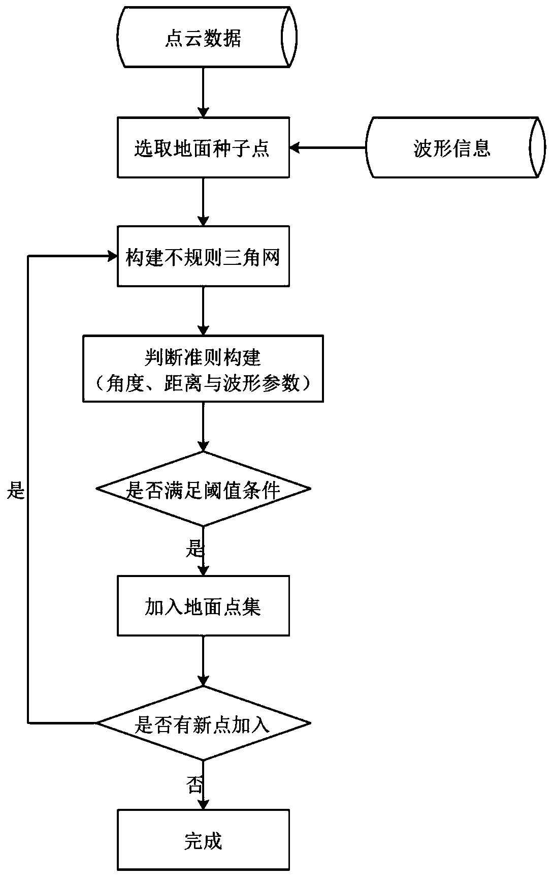
[0034] refer to figure 1 As shown, the present invention discloses a progressively encrypted triangular network LiDAR point cloud filtering method under the assistance of waveform information, which includes the following steps:

[0035] S1. Based on the LM algorithm, Gaussian decomposition is performed on the full waveform lidar data, and relevant waveform parameters are extracted:

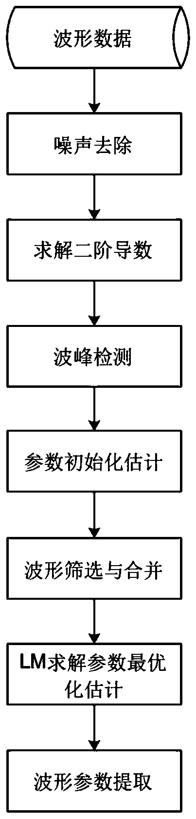
[0036] refer to figure 2 As shown, step S1 specifically includes:

[0037] S11. Calculate the inflection point and the initial peak position of the full-waveform laser radar data, and determine the initial value of the Gaussian decomposition parameter by the two adjacent inflection points of odd and even;

[0038] According to the waveform principle of waveform laser radar, it can be known that the laser echo waveform can be expressed as the sum of multiple Gaussian functions. Usually, for a standard Gaussian distribution function, by solving its first-order and second-order partial derivativ...


PUM


Abstract

The invention discloses a progressive encryption triangulation network LiDAR point cloud filtering method under the assistance of waveform information. The method comprises the steps that firstly, Gaussian decomposition is conducted on full-waveform laser radar data through an LM algorithm, relevant waveform parameters are extracted, progressive encryption triangular network filtering is conductedon laser radar point cloud based on the relevant waveform parameters and spatial geometric information, and a point cloud filtering result is obtained; According to the invention, the LM algorithm-based full-waveform laser radar data Gaussian decomposition algorithm has global convergence; and meanwhile, the point cloud waveform information and the spatial geometric information are fused, so thatthe reliability of seed point selection and ground point judgment is improved, and the precision of point cloud filtering can be improved.

Description

technical field [0001] The invention relates to the technical field of remote sensing, in particular to a progressively encrypted triangular network LiDAR point cloud filtering method assisted by waveform information. Background technique [0002] Laser radar (LiDAR) ranging technology LiDAR is an active remote sensing technology that can directly obtain three-dimensional information on the ground, and can achieve all-weather and all-weather data acquisition. Airborne lidar refers to the laser scanner carried by the aircraft. Compared with digital photogrammetry, airborne lidar has the advantage of directly recording the surface elevation. From digital elevation model surveying and mapping, urban traffic research, to water conservancy and ecological engineering, airborne lidar is gradually popular in various environmental applications and provides important research data. [0003] The three-dimensional data obtained by scanning the ground with airborne lidar becomes point ...

Claims


Application Information

Patent Timeline
Patent Type & Authority Applications(China)
IPC IPC(8): G06T5/00G06T5/50
Inventor 王成勤海明习晓环聂胜
Owner INST OF REMOTE SENSING & DIGITAL EARTH CHINESE ACADEMY OF SCI
Why Eureka
Try Eureka