
a GIS-based data visualization interaction system

An interactive system and data technology, applied in the field of visual interaction, can solve the problem of lack of GIS data visualization device and so on

Inactive Publication Date: 2019-06-21
福建奇点时空数字科技有限公司
View PDF6 Cites 1 Cited by
  • Summary
  • Abstract
  • Description
  • Claims
  • Application Information

AI Technical Summary

Problems solved by technology

After the user obtains the location information through related technologies, he still needs to understand the geographical environment he is in, query and analyze the environmental information, so as to provide information support and services for user activities; GIS data visualization devices are lacking in the prior art

Method used


Image

  • a GIS-based data visualization interaction system
  • a GIS-based data visualization interaction system

Examples


Embodiment Construction

[0022] In order to make the object, technical solution and advantages of the present invention clearer, the present invention will be further described in detail below in combination with specific embodiments and with reference to the accompanying drawings. It should be understood that these descriptions are exemplary only, and are not intended to limit the scope of the present invention. Also, in the following description, descriptions of well-known structures and techniques are omitted to avoid unnecessarily obscuring the concept of the present invention.

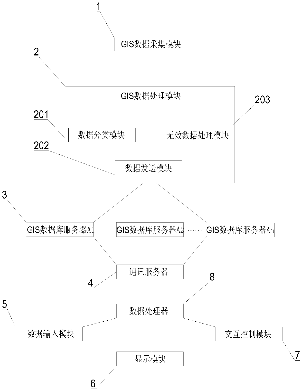
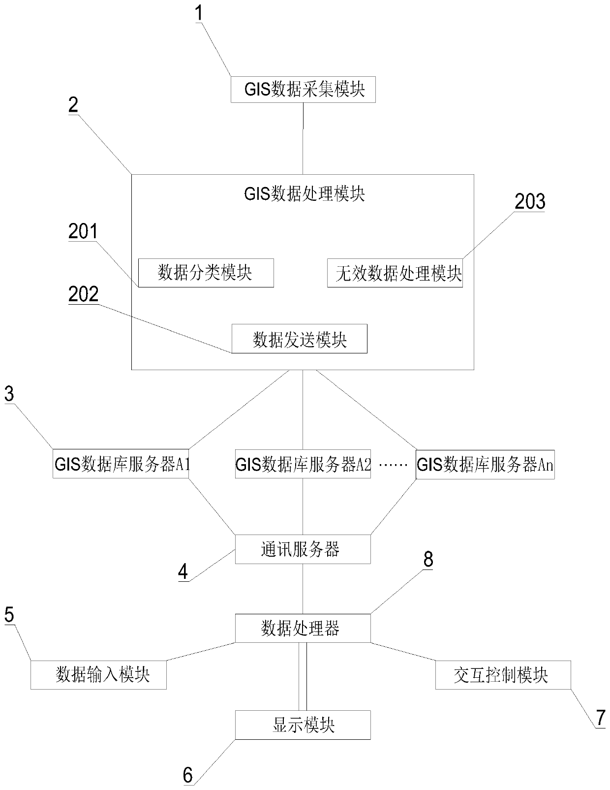
[0023] Such as figure 1 As shown, a GIS-based data visualization interactive system proposed by the present invention includes a GIS data acquisition module 1, a GIS data processing module 2, a GIS database server 3, a communication server 4, a data processor 8, a data input module 5, an interactive Control module 7 and display module 6;

[0024] GIS data acquisition module 1 collects GIS raw data; GIS data acquisition ...


PUM


Abstract

A GIS-based data visualization interaction system comprises a GIS data acquisition module, a GIS data processing module, a GIS database server, a communication server, a data processor, a data input module, an interaction control module and a display module, Wherein the GIS data acquisition module is used for acquiring GIS original data; The GIS data acquisition module is in communication connection with the GIS data processing module; The GIS data processing module comprises a data classification module, an invalid data processing module and a data sending module; The invalid data processingmodule is used for processing the classified GIS original data; A plurality of GIS database servers are arranged; The data sending module is in communication connection with each GIS database server;The communication server is in communication connection with each GIS database server; According to the invention, the GIS information of the same place is sent to different GIS databases for storage,and the user side can call the data information at the same time, so that the loading speed of the user side is improved, and the user experience is improved.

Description

technical field [0001] The invention relates to the technical field of visual interaction, in particular to a GIS-based data visual interactive system. Background technique [0002] Geographic Information System (Geographic Information System or Geo-Information system, GIS) is sometimes called "geographic information system". It is a specific and very important spatial information system. It is a technical system that collects, stores, manages, calculates, analyzes, displays and describes the relevant geographical distribution data in the entire or part of the earth's surface (including the atmosphere) space with the support of computer hardware and software systems. Location and geographic information are both the core and the foundation of LBS. A simple latitude and longitude coordinate will be recognized and understood by users only after it is placed in specific geographic information and represented as a certain location, sign, or orientation. After users obtain loca...

Claims


Application Information

Patent Timeline
IPC IPC(8): G06F16/29G06F16/25
Inventor 刘家祥
Owner 福建奇点时空数字科技有限公司
Learn More