
A Waveform Resetting Method for Satellite Radar Altimetry Based on Waveform Derivative

A waveform re-determination and first-order derivative technology, applied in the field of satellite altimetry, can solve the problems affecting the final parameter estimation, different re-determination accuracy, and inability to solve related parameters, etc., to achieve the effect of reliable re-determination results, easy implementation, and easy handling.

Active Publication Date: 2021-04-30
SHANDONG UNIV OF SCI & TECH
View PDF4 Cites 0 Cited by
  • Summary
  • Abstract
  • Description
  • Claims
  • Application Information

AI Technical Summary

Problems solved by technology

[0005] The resetting algorithm based on empirical statistics is an algorithm that relies on observation and actual experience. For example, the Threshold algorithm determines the threshold coefficient based on empirical formulas. It has strong adaptability and stable results, but the selection of the threshold coefficient has no clear physical meaning and lacks principle. Detailed analysis of interpretation and performance; resetting algorithms based on function fitting, such as the β parameter algorithm, which takes into account the physical mechanism of the waveform and selects parameters with a certain physical meaning to fit the waveform. This algorithm has high calculation accuracy, but parameter calculation requires iteration , the termination condition of the iteration will affect the final parameter estimation, and the calculated parameters will deviate from the actual meaning. These factors may make it impossible to solve the relevant parameters; the resetting algorithm based on waveform wavelet analysis is to deal with the waveform of multiple leading edges, and determine through data comparison The most accurate re-distance, but it is very difficult to judge and select the wavelet
[0006] Due to the complexity of the echo waveform, the current rescheduling method cannot satisfy various echo waveforms, and the rescheduling accuracy of different rescheduling methods is also different. Therefore, the existing waveform rescheduling method needs to be further improved

Method used


Image

  • A Waveform Resetting Method for Satellite Radar Altimetry Based on Waveform Derivative
  • A Waveform Resetting Method for Satellite Radar Altimetry Based on Waveform Derivative
  • A Waveform Resetting Method for Satellite Radar Altimetry Based on Waveform Derivative

Examples


Embodiment Construction

[0096] Below in conjunction with accompanying drawing and specific embodiment the present invention is described in further detail:

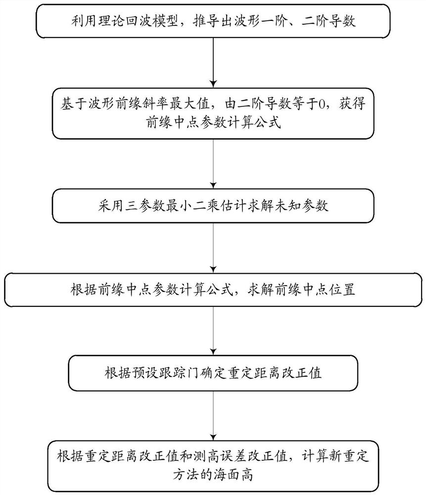
[0097] Such as figure 1 As shown, a method for resetting the satellite radar altimetry waveform based on the waveform derivative includes the following steps:

[0098] s1. Deduce the first and second derivatives of the echo waveform based on the theoretical echo model; use the maximum slope of the leading edge of the waveform, that is, when the second derivative is equal to zero, the calculation formula for the midpoint of the leading edge is obtained.

[0099] The expression of the average power W(t) of the radar sea surface echo waveform can be expressed as the convolution form of three quantities: the radar system point target response function P τ (t), the radar impulse response function P of the flat sea surface fs (t) and the probability density function q(t) of the reflective surface point height, namely

[0100] formula, Represent...


PUM


Abstract

The invention discloses a satellite radar altimetry waveform resetting method based on the waveform derivative, which comprises the following steps: deriving the first-order derivative and the second-order derivative of the echo waveform based on the theoretical echo model; using the maximum value of the slope of the leading edge of the waveform, That is, when the second-order derivative is equal to zero, the calculation formula of the midpoint of the leading edge is obtained; the unknown parameters in the calculation formula of the midpoint of the leading edge are solved by fitting, and the position of the midpoint of the leading edge is determined; the resetting distance correction value is determined according to the preset tracking gate ;Further, according to the correction value of the resetting distance and the correction value of the height measurement error, calculate the sea surface height after the resetting method. The invention can improve the quality of satellite altimetry data, the high precision of the rescheduled sea surface is better than that of the conventional rescheduled method, and the correlation between the rescheduled sea surface height and the geoid height is obviously improved.

Description

technical field [0001] The invention belongs to the technical field of satellite altimetry, and relates to a method for resetting satellite radar altimetry waveforms based on waveform derivatives. Background technique [0002] The satellite altimetry technology developed since the 1970s uses the microwave radar altimeter on the satellite to measure the distance from the satellite to the sea surface, the effective wave height and the backscatter coefficient in real time, and obtain a large amount of ocean data. Oceanography, oceanography, geophysics, etc. provided basic data. [0003] In order to obtain high-quality altimetry data, geophysical and propagation medium corrections and echo signal processing are required. In the past ten years, although geophysics and propagation medium correction have made great progress, it is still a challenge to obtain a high-precision sea surface height, especially for the processing of echo signals (waveform re-tracking). Because the echo...

Claims


Application Information

Patent Timeline
Patent Type & Authority Patents(China)
IPC IPC(8): G01S7/41G01S13/88
CPCG01S7/418G01S13/882
Inventor 郭金运李真刘新袁佳佳牛余朋祝程程
Owner SHANDONG UNIV OF SCI & TECH
Learn More