Railway existing line control measuring system based on satellite navigation and positioning reference station network

A positioning datum and satellite navigation technology, applied in satellite radio beacon positioning systems, radio wave measurement systems, railway vehicle shape measuring instruments, etc. problems, to achieve the effect of simplifying the burden of manual work, reducing complexity and saving costs

Active Publication Date: 2019-07-12
CHINA RAILWAY FIRST SURVEY & DESIGN INST GRP +1
View PDF9 Cites 8 Cited by
  • Summary
  • Abstract
  • Description
  • Claims
  • Application Information

AI Technical Summary

Problems solved by technology

Most of these measurement and control networks have defects such as high deployment costs, difficulty in implementing measurements, regular organization of retests, and low degree of automation.

Method used


Image

  • Railway existing line control measuring system based on satellite navigation and positioning reference station network
  • Railway existing line control measuring system based on satellite navigation and positioning reference station network
  • Railway existing line control measuring system based on satellite navigation and positioning reference station network

Examples


Embodiment Construction

[0021] The present invention will be described in detail below in combination with specific embodiments.

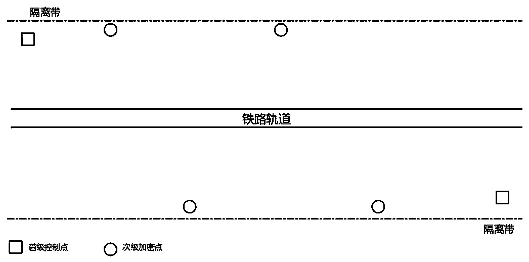
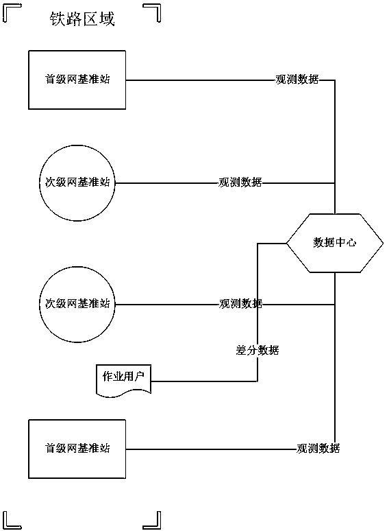
[0022] The invention constructs a multi-level control and measurement system, that is, an existing railway line control and measurement system based on a satellite navigation and positioning reference station network, and the system is divided into a first level and a second level. The first-level network is composed of the framework points of the Global Navigation Satellite System (GNSS) continuous operation observation stations arranged along the existing railway lines, and the GNSS observation data are transmitted to the data center in real time for processing and release. The secondary network is composed of secondary reference network control points that are convenient for quick installation and disassembly of GNSS receivers on the basis of the first-level frame points. On the one hand, the data center obtains the precise coordinate time series of the first-level net...


PUM


Abstract

The invention relates to a railway existing line control measuring system based on a satellite navigation and positioning reference station network. The railway existing line control measuring systemis divided into a primary stage and a secondary stage; on the one hand, a data centre acquires precise primary stage network coordinate time series through automatic global navigation satellite systemdata processing, precise coordinates of a frame point are updated according to coordinate change difference, and in this way the dynamic updating maintenance of a primary stage network coordinates iscompleted; and on the other hand, when a primary stage network cannot meet a service requirement, a global navigation satellite system receiver is installed on the nearest secondary stage network control pile point of an operation point, observation data is transmitted to a data process centre in real time, the data process centre then acquires precise coordinates of the secondary stage network control point through the quick automatic global navigation satellite system data processing, and the precise coordinates are updated according to the coordinate change difference, so that periodical updating maintenance of coordinates of the control point of the secondary stage network is achieved.

Description

technical field [0001] The invention relates to the technical field of railway line maintenance and train safety operation, in particular to an existing railway line control and measurement system based on a satellite navigation and positioning reference station network. Background technique [0002] Existing railway lines require high-precision and high-availability measurement and positioning systems for daily inspection, maintenance, and monitoring during the construction phase and post-completion operation phase. However, in order to ensure the safety of the operation, the operating time in the closed operation area with existing lines is becoming more and more limited. Most of the current strip measurement control networks adopt the traditional hierarchical control network layout and level-by-level control method. The railway control network generally consists of the frame network CP0, the basic control network CPI, the line control network CPII and the track control ne...

Claims


Application Information

Patent Timeline
Patent Type & Authority Applications(China)
IPC IPC(8): B61K9/08G01S19/42G01S19/03G01S19/24
CPCB61K9/08G01S19/03G01S19/24G01S19/42
Inventor 任晓春许超钤王玮张良胡明贤
Owner CHINA RAILWAY FIRST SURVEY & DESIGN INST GRP
Why Eureka
Try Eureka