Multi-air strip image splicing and positioning method based on unmanned aerial vehicle flight path constraint

A technology of image mosaic and positioning method, applied in satellite radio beacon positioning system, image data processing, graphics and image conversion, etc., can solve the problems of mutual intersection, overlap, overall error accumulation, error, etc., to reduce cumulative error and improve The effect of positioning accuracy and improving the quality of splicing

Active Publication Date: 2019-08-06
UNIV OF ELECTRONIC SCI & TECH OF CHINA
View PDF19 Cites 5 Cited by
  • Summary
  • Abstract
  • Description
  • Claims
  • Application Information

AI Technical Summary

Problems solved by technology

[0003] At present, the stitching method of UAV aerial images is mainly based on image features. This method is ideal for the stitching effect of a single flight belt image, but when multiple flight belts are stitched, two or more flight belts often overlap and overlap. ; The traditional UAV image positioning method mainl

Method used


Image

  • Multi-air strip image splicing and positioning method based on unmanned aerial vehicle flight path constraint
  • Multi-air strip image splicing and positioning method based on unmanned aerial vehicle flight path constraint
  • Multi-air strip image splicing and positioning method based on unmanned aerial vehicle flight path constraint

Examples


Embodiment Construction

[0045] The present invention will be described in further detail below in conjunction with the accompanying drawings and embodiments.

[0046] This embodiment provides a multi-strip image stitching and positioning method based on UAV track constraints, which can improve the stitching quality of the images between the flight strips and the positioning accuracy of the panorama, including image preprocessing, key frame selection, and image features. Extraction, image feature matching, track constraints, and GPS positioning of any point in the panorama are six steps; the specific steps are as follows:

[0047] Step 1. Data preprocessing

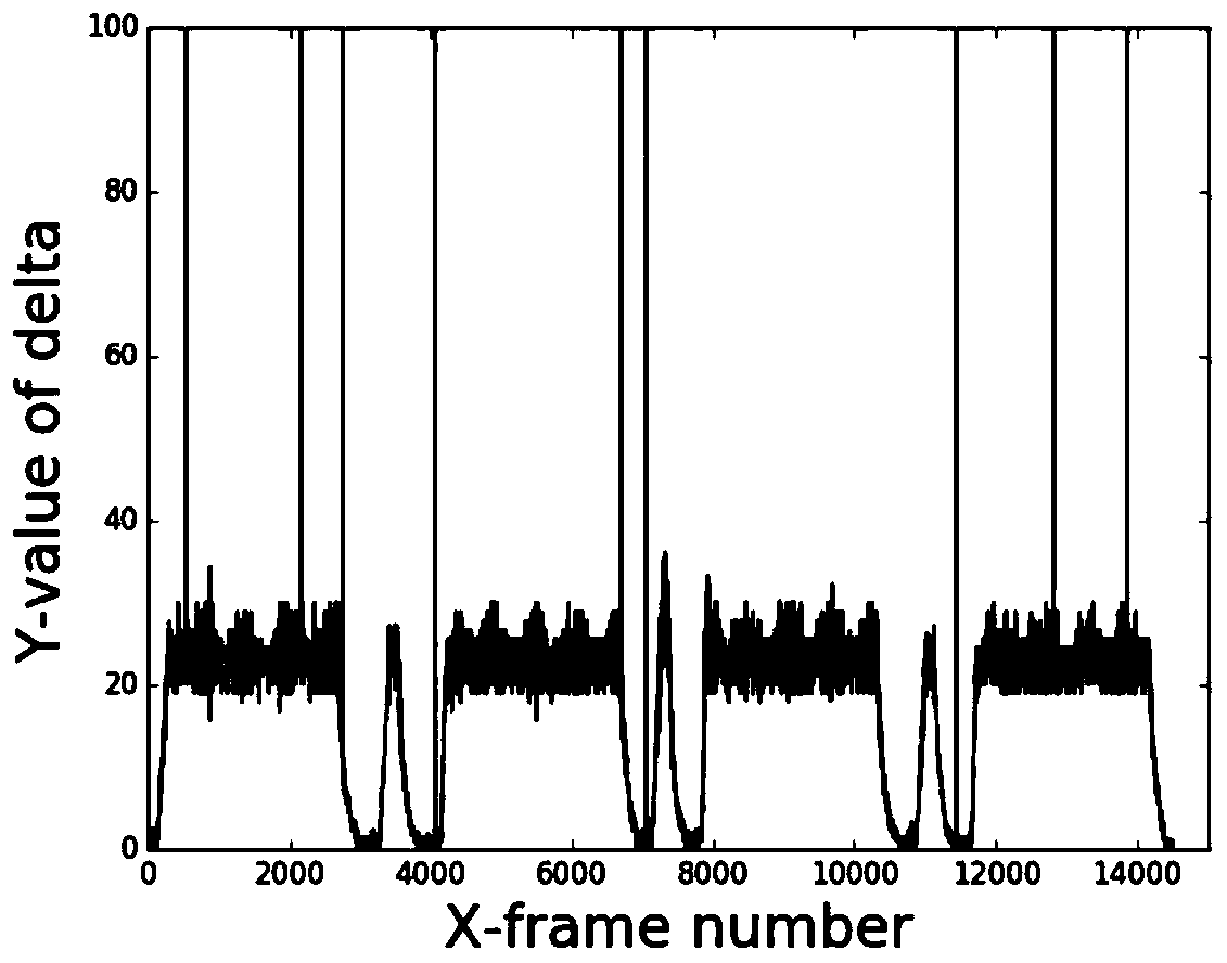
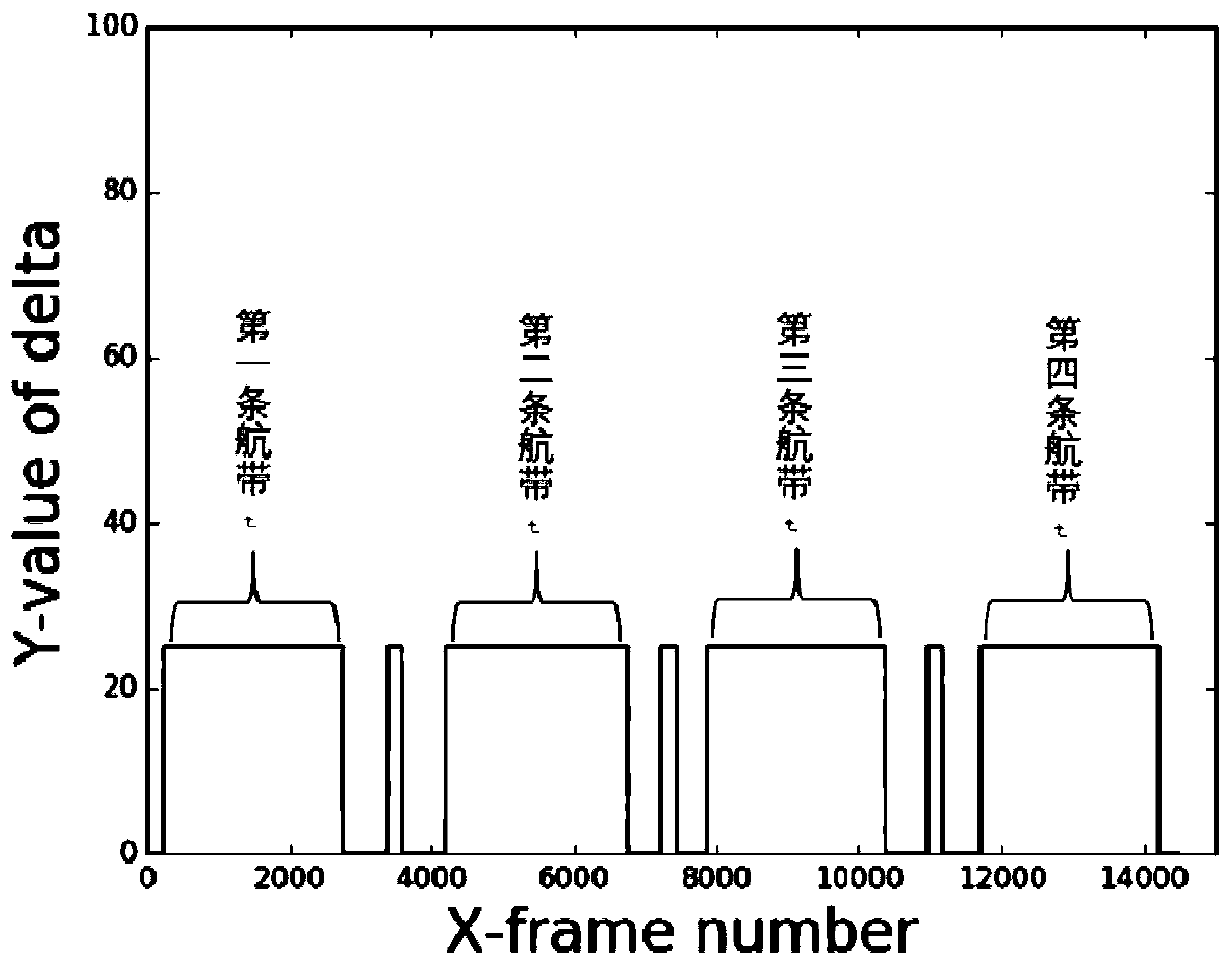
[0048] First, before starting the splicing, read the GPS coordinate information of all images in the video, convert it into UTM coordinates and store it in the data container utmData. Starting from the first frame image, calculate the difference between the UTM coordinates of the two frames before and after the image, in order: u 1 ,U 2 ,...,U...


PUM


Abstract

The invention relates to the field of computer image processing and map surveying and mapping, in particular to a multi-air strip video image splicing and positioning method based on multi-rotor unmanned aerial vehicle flight path constraint, which is mainly used for improving the splicing quality of the images between the air strips and the positioning precision of a panorama. The method comprises the following steps of firstly, processing the GPS information of all images in an aerial video, obtaining the flight path information, then performing a series of image processing operations on theto-be-spliced image to obtain a homography matrix, mapping the to-be-spliced image into the spliced image by utilizing the matrix, and finally realizing a GPS positioning function by utilizing a one-to-one correspondence relationship between the image and the GPS information. According to the invention, the image splicing effect under the condition that the plurality of air strips are parallel can be effectively improved, all scene information shot during the flight process of the unmanned aerial vehicle can be truly reflected by the obtained splicing result, in addition, the GPS coordinatesof each pixel point in the splicing result can be positioned by combining the GPS information acquired in the flight process, and the positioning error is not more than 10m.

Description

technical field [0001] The present invention relates to the field of computer image processing and map surveying and mapping, specifically a multi-strip video image splicing and positioning method based on multi-rotor UAV track constraints, which is mainly used to improve the splicing quality of images between flight strips and the positioning accuracy of panoramas . Background technique [0002] Multi-rotor drones have been widely used in disaster relief, military reconnaissance, crop disease detection, environmental protection and other surveying and mapping technology fields due to their flexible take-off and landing methods, low-altitude tracking autonomous flight characteristics, and rapid response and stable flight capabilities. . Most of the requirements are directly manifested in obtaining the panoramic view of the flight operation area and the GPS information of each point in the map. [0003] At present, the stitching method of UAV aerial images is mainly based o...

Claims


Application Information

Patent Timeline
IPC IPC(8): G06T3/40G01S19/42
CPCG06T3/4038G01S19/42Y02T10/40
Inventor 解梅罗尧易鑫夏子涵
Owner UNIV OF ELECTRONIC SCI & TECH OF CHINA
Why Eureka
Try Eureka