
Method for monitoring earth surface deformation based on sequential InSAR technology

A surface deformation and timing technology, applied in the field of transmission line survey, can solve problems such as accuracy needs to be further improved, defects, assumptions cannot be established, etc.

Pending Publication Date: 2019-08-09
CHINA ELECTRIC POWER RES INST +2
View PDF0 Cites 7 Cited by
  • Summary
  • Abstract
  • Description
  • Claims
  • Application Information

AI Technical Summary

Problems solved by technology

However, the existing multi-baseline phase unwrapping methods take into account the new assumption that the surface does not undergo large deformations during the acquisition of time-series SAR images
Obviously, this assumption is generally satisfied, but in areas with more artificial activities or complex geological conditions, the surface often deforms over time, and the assumption cannot be established, which leads to defects in the existing method, and the accuracy needs to be further improved

Method used


Image

  • Method for monitoring earth surface deformation based on sequential InSAR technology
  • Method for monitoring earth surface deformation based on sequential InSAR technology
  • Method for monitoring earth surface deformation based on sequential InSAR technology

Examples


Embodiment

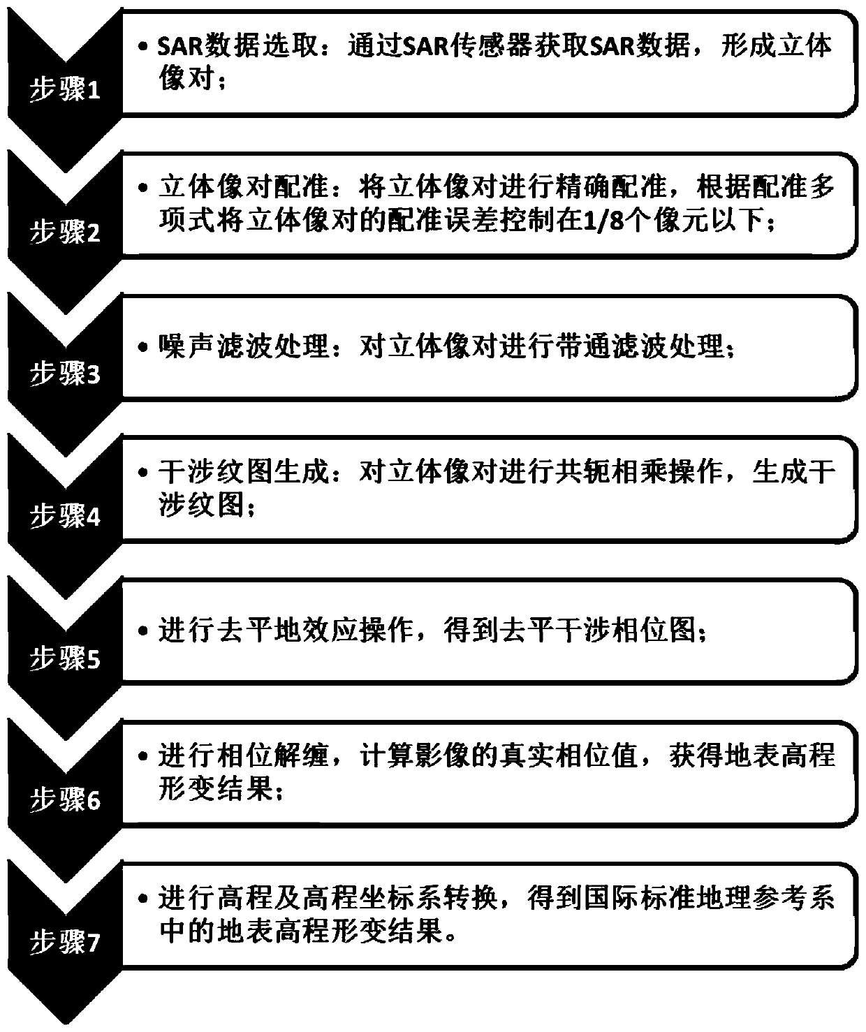
[0071] The present invention provides a method for monitoring surface deformation based on time-series InSAR technology, such as figure 1 shown, including:

[0072] Step 1, SAR data selection: Obtain SAR data through the SAR sensor to form a stereo pair;

[0073] Step 2, stereo image pair registration: accurately register the stereo image pair, and control the registration error of the stereo image pair below 1 / 8 pixel according to the registration polynomial;

[0074] Step 3, noise filtering processing: performing band-pass filtering processing on the stereo pair;

[0075] Step 4, generation of interference pattern: perform conjugate multiplication operation on the stereo pair to generate interference pattern;

[0076] Step 5, perform a flattening operation to obtain a flattened interferogram;

[0077] Step 6, perform phase unwrapping, calculate the real phase value of the image, and obtain the result of surface elevation deformation;

[0078] Step 7: Perform elevation an...


PUM


Abstract

The invention relates to a method for monitoring the earth surface deformation based on a sequential InSAR technology. The method comprises steps of SAR data selection, stereo image pair registration,noise filtering processing, interference fringe pattern generation, de-leveling effect execution, phase unwrapping, elevation and elevation coordinate system conversion. The method is especially suitable for high-precision phase unwrapping in areas with large topographic relief, such as a mountainous area and frequent surface deformation, such as an artificial active area; defects caused by inapplicability to the phase continuity assumption and the surface elevation invariance assumption in the conventional algorithm can be overcome; the phase unwrapping accuracy can be improved and thus thesurface elevation deformation inversion accuracy can be enhanced; and a high-precision monitoring way is provided for geological disasters along the transmission line in the region.

Description

technical field [0001] The invention relates to the field of power transmission line survey, in particular to a method for monitoring surface deformation based on time series InSAR technology. Background technique [0002] my country is a country where geological disasters often occur. In recent years, the probability of geological disasters has increased greatly, such as earthquakes, landslides, etc. The external manifestation of these geological disasters is the deformation of the surface, which will cause great harm. The safety of human life will be greatly affected. Therefore, it is very important to detect these disasters as early as possible and take timely preventive measures. [0003] As a very effective technology, Synthetic Aperture Radar Interferometry (InSAR) restores the original information through radar, and the result is very accurate, so it has great development potential in many aspects, such as underground resource detection and disaster monitoring. In re...

Claims


Application Information

Patent Timeline
Patent Type & Authority Applications(China)
IPC IPC(8): G01S13/90G01S13/88
CPCG01S13/885G01S13/9023
Inventor 杨知费香泽欧文浩赵斌滨马潇马超王轶禹冯长有姚伟锋
Owner CHINA ELECTRIC POWER RES INST
Learn More