
A comprehensive monitoring platform and method for protected areas based on the Internet of Things

A technology of comprehensive monitoring and protected areas, applied in geographic information databases, instruments, data processing applications, etc., can solve the problems of single type of system data source application, weak foundation of monitoring technology informatization, weak processing ability, etc.

Active Publication Date: 2021-06-15
MINISTRY OF ECOLOGY & ENVIRONMENT CENT FOR SATELLITE APPL ON ECOLOGY ENVIRONMENT
View PDF5 Cites 0 Cited by
  • Summary
  • Abstract
  • Description
  • Claims
  • Application Information

AI Technical Summary

Problems solved by technology

However, the quality of satellite remote sensing monitoring products is easily affected by objective factors such as atmospheric radiation, sensors, the state of the observed target, and the weather; and traditional ecological protection work mainly relies on manual work, and the information base of monitoring technology is weak, and the data source and application type of the system Single, weak processing capacity; only using satellite remote sensing detection technology is difficult to accurately and efficiently complete the monitoring of ecological protection red line

Method used


Image

  • A comprehensive monitoring platform and method for protected areas based on the Internet of Things
  • A comprehensive monitoring platform and method for protected areas based on the Internet of Things
  • A comprehensive monitoring platform and method for protected areas based on the Internet of Things

Examples


Embodiment 1

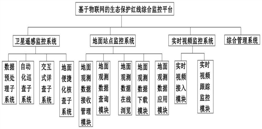
[0069] The embodiment of the present invention discloses a comprehensive monitoring platform for protected areas based on the Internet of Things, such as figure 1 As shown, including: satellite remote sensing monitoring system, ground site monitoring system, real-time video monitoring system and integrated management system; satellite remote sensing monitoring system, ground site monitoring system and real-time video monitoring system are all connected to the integrated management system;

[0070] The satellite remote sensing monitoring system is used to process and analyze the satellite remote sensing data in the supervision area, and obtain the monitoring results of human activities;

[0071] The ground station monitoring system is used to obtain the ground observation data of the supervision area and obtain the supervision results of the ecosystem status;

[0072] The real-time video monitoring system is used to obtain and supervise the video image data in the supervision a...

Embodiment 2

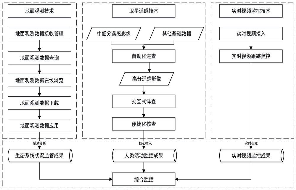
[0089] A comprehensive monitoring method for protected areas based on the Internet of Things, such as figure 2 As shown, it includes the following steps: obtain human activity monitoring results, ecosystem status monitoring results and real-time video monitoring results respectively, comprehensively analyze all the obtained results, and form a result report.

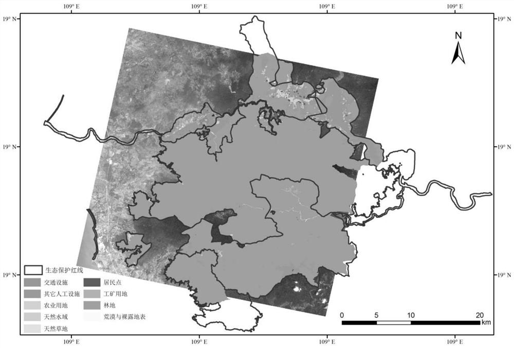
[0090] Taking the red line area around Jianfengling in Hainan Province (referred to as "the red line area of ​​Hainan Province") as an example, the specific application steps will be explained one by one.

[0091] Step S1. Obtain basic regional data and preprocess the basic data.

[0092] a. Regional basic data include boundary data of protected areas in Hainan Province, background data of red line areas in Hainan Province, remote sensing data and elevation data. in:

[0093] The boundary data of the Red Line Reserve comes from the Satellite Environment Application Center of the Ministry of Environmental Protection, a...


PUM


Abstract

The invention discloses a protected area comprehensive monitoring platform based on the Internet of Things, including: a satellite remote sensing monitoring system, a ground site monitoring system, a real-time video monitoring system and a comprehensive management system; the satellite remote sensing monitoring system, the ground site monitoring system and the real-time video monitoring system are all connected to the integrated management system; a method for comprehensive monitoring of protected areas based on the Internet of Things is also disclosed, including the following steps: obtaining human activity monitoring results, ecosystem status monitoring results, and real-time video Monitor the results, comprehensively analyze all the obtained results, and form a result report. Realize the comprehensive analysis of various monitoring results, and realize the application of space-ground integration technology based on the Internet of Things in the comprehensive monitoring of protected areas.

Description

technical field [0001] The invention relates to the technical field of integrated monitoring of ecological protection sites, and more specifically relates to an integrated monitoring platform for protected areas based on the Internet of Things and a method thereof. Background technique [0002] At present, the supervision of national protected areas is a long-term and complicated process. As one of the conventional monitoring methods, satellite remote sensing technology has the advantages of wide monitoring range and high frequency, which can greatly improve the efficiency of supervision work. However, the quality of satellite remote sensing monitoring products is easily affected by objective factors such as atmospheric radiation, sensors, the state of the observed target, and the weather; and traditional ecological protection work mainly relies on manual labor, and the information base of monitoring technology is weak, and the data source and application type of the system ...

Claims


Application Information

Patent Timeline
Patent Type & Authority Patents(China)
IPC IPC(8): G06F16/29G06Q50/00
CPCG06Q50/00G06F16/29
Inventor 蔡明勇侯鹏肖如林翟俊杨旻刘慧明孙晨曦
Owner MINISTRY OF ECOLOGY & ENVIRONMENT CENT FOR SATELLITE APPL ON ECOLOGY ENVIRONMENT
Learn More