
Multi-source fusion unmanned aerial vehicle indoor and outdoor positioning method and system

An indoor and outdoor positioning, unmanned vehicle technology, applied in satellite radio beacon positioning system, radio wave measurement system, photo interpretation and other directions, can solve problems such as errors, inability to locate, and the positioning signals of space satellites are easily blocked

Active Publication Date: 2019-09-17
WUHAN UNIV OF TECH
View PDF7 Cites 45 Cited by
  • Summary
  • Abstract
  • Description
  • Claims
  • Application Information

AI Technical Summary

Problems solved by technology

[0003] As far as the current technology is concerned, the positioning accuracy and stability of one or two sensors alone are difficult to meet the requirements. The method of using vision or laser odometer is relatively mature. However, its stability and accuracy have fatal shortcomings in outdoor environments, high-speed motion and weak light environments, and both of them have high cumulative errors in large scenes; use IMU to obtain the instantaneous displacement increment of the vehicle to Calculating the trajectory of the vehicle, and then assisting GPS positioning, has a large cumulative error, and the error caused by different weather conditions in the same place varies greatly, and the positioning signals from space satellites are easily blocked, such as tunnels, viaducts, Big trees, tall buildings, etc. will block the signal of the satellite positioning system. Once the signal of the satellite positioning system is blocked, it is easy to cause a large error or even fail to locate

Method used


Image

  • Multi-source fusion unmanned aerial vehicle indoor and outdoor positioning method and system
  • Multi-source fusion unmanned aerial vehicle indoor and outdoor positioning method and system
  • Multi-source fusion unmanned aerial vehicle indoor and outdoor positioning method and system

Examples


Embodiment Construction

[0072] In order to make the object, technical solution and advantages of the present invention clearer, the present invention will be further described in detail below in conjunction with the accompanying drawings and embodiments. It should be understood that the specific embodiments described here are only used to explain the present invention, not to limit the present invention.

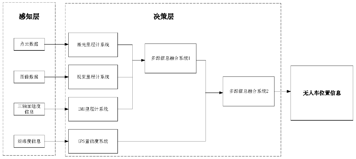
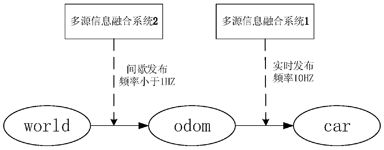
[0073] Such as figure 1 As shown, the multi-source fusion unmanned vehicle indoor and outdoor positioning system of the present invention includes a perception layer and a decision-making layer. The perception layer mainly includes multiple sensors, mainly including lidar, camera, IMU and GPS, through which the current environmental information of the unmanned vehicle is collected. The decision-making layer includes visual odometry system, laser odometry system, IMU odometry system, multi-source fusion system 1 and multi-source fusion system 2.

[0074] The present invention designs a separate po...


PUM


Abstract

The invention discloses a multi-source fusion unmanned aerial vehicle indoor and outdoor positioning method and system. The system comprises a sensing layer and a decision making layer, wherein the sensing layer comprises a plurality of sensors, the decision making layer comprises a visual odometer system, a laser odometer system, an IMU odometer system and two multi-source fusion systems. IMU information is selected, relatively good initial gesture and gravity direction are provided, and the scale problem of a visual odometer and the inherent defect of scale drift are made up; high accuracy information of a laser radar and the visual odometer are fused, the motion estimation error is reduced, and the system robustness is improved; and with the addition of GPS absolute position correction, and an accumulated error of the system is further reduced. By the method, accurate positioning information can be generated according to true motion track of a vehicle, the positioning accuracy is high, indoor and outdoor seamless switching can be achieved, the positioning stability of the vehicle in an indoor and outdoor environment is improved, high robustness is achieved, and the system is suitable for indoor and outdoor positioning of a pilotless automobile in a large scene.

Description

technical field [0001] The invention relates to the field of unmanned vehicle positioning, in particular to a multi-source data fusion unmanned vehicle positioning method and system. Background technique [0002] With the rapid development of technologies such as sensors, computer information, and artificial intelligence, the research on unmanned vehicle technology has attracted more and more attention from experts and scholars at home and abroad. The unmanned vehicle acquires external environmental information and its own status information through sensors, and realizes autonomous movement and completes certain tasks based on these information. Autonomous positioning is the basis of intelligent navigation and environmental exploration research for unmanned vehicles. Since it is difficult for a single sensor to obtain all the information required by the system, the information fusion of multiple sensors becomes the key to autonomous vehicle positioning. [0003] According t...

Claims


Application Information

Patent Timeline
IPC IPC(8): G01C21/00G01C21/16G01C21/20G01C21/28G01C11/06G01C22/00G01S17/02G01S19/45G01S19/47
CPCG01C21/005G01C21/165G01C21/206G01C21/28G01C11/06G01C22/00G01S19/45G01S19/47G01S17/86
Inventor 黄妙华龚杰蒋剑飞
Owner WUHAN UNIV OF TECH
Learn More