Land requisition and demolition application management system based on BIM + GIS technology

A technology of application management and basic application, applied in the field of land acquisition and demolition application management system, to achieve the effect of reducing error rate, facilitating data viewing, and reducing processing workload

Active Publication Date: 2019-10-22
ANHUI DIGITAL INTELLIGENT CONSTR RES INST CO LTD +1
View PDF3 Cites 4 Cited by
  • Summary
  • Abstract
  • Description
  • Claims
  • Application Information

AI Technical Summary

Problems solved by technology

[0005] In view of the problems that the existing land acquisition and demolition mode cannot truly restore the demolition scene, the error rate of on-site information collection is high, and the data loss is serious, the present invention provides a land acquisition and demolition appl

Method used


Image

  • Land requisition and demolition application management system based on BIM + GIS technology

Examples


Embodiment 1

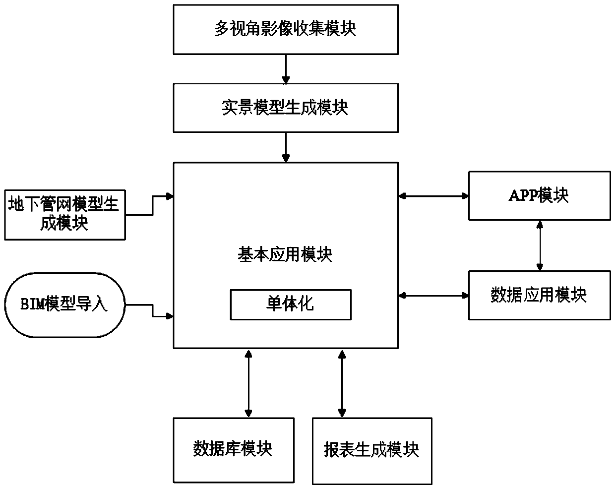
[0047] A land acquisition and demolition application management system based on BIM+GIS technology, such as figure 1 shown, including:

[0048] (1) Multi-view image collection module, used to obtain multi-view images of the expropriation and demolition area;

[0049] UAV oblique photogrammetry is a newly developed technology in the field of international surveying, mapping and remote sensing. Its essence is to carry multiple sensors on the same flight platform, and simultaneously collect high-resolution The POS data obtained by the differential system on the platform and a small amount of image control point data on the ground are processed by relevant software to obtain digital surface models, digital orthophoto images and three-dimensional model photogrammetry technology.

[0050] The specific process of obtaining multi-view images of the requisitioned and demolished area using UAV oblique photography technology includes:

[0051] Equipped with more than 2 sensors on the f...


PUM


Abstract

The invention discloses a land requisition and demolition application management system based on a BIM + GIS technology, and belongs to the technical field of engineering management. The system comprises a multi-view image collection module, a real scene model generation module, an underground pipe network model generation module, a basic application module, an APP module and a data application module. According to the invention, the live-action model generated by the multi-view image is combined with the underground network management model, and the data is accurately recorded and the demolition scene is truly restored in a single mode on the generated application model, so that the data acquisition process is simplified, the data loss is prevented, and the data error rate is greatly reduced. According to the system disclosed by the invention, the data binding between the data and the model can be realized in the system by inputting the related business investigation data into the monomeric model, so that the data can be conveniently checked; other personnel can synchronously check the data input by the business personnel in the field in the system, so that the real-time check, sharing and interaction of the data are realized.

Description

technical field [0001] The present invention relates to the technical field of engineering management, and more specifically, relates to a land acquisition and demolition application management system based on BIM+GIS technology. Background technique [0002] At present, the main process of land acquisition and demolition mode is aerial photography of satellite images, field data investigation, on-site review of construction units, and offline progress management. The specific operation method is to obtain satellite aerial photographs, combined with CAD drawings of requisition and demolition plans, to draw red line maps for requisition and demolition, and the field personnel of the Land and Resources Bureau will conduct cadastral element measurement, and then hand over the relevant data to the construction unit, which will carry out on-site red line stakeout. During the process of setting out the red line, it is necessary to visit the requisitioned area, investigate the owne...

Claims


Application Information

Patent Timeline
IPC IPC(8): G06F17/50G06F16/29G06Q90/00
CPCG06F16/29G06Q90/205G06F30/13
Inventor 陈路耿天宝杨铭宋林刘道学胡伟刘振邦李亮梁昊张忆晨
Owner ANHUI DIGITAL INTELLIGENT CONSTR RES INST CO LTD
Why Eureka
Try Eureka