Inertial navigation positioning system and positioning method for underground mining mobile device

A mobile device and inertial navigation technology, applied in the field of navigation and positioning, can solve problems such as accumulated errors, inaccurate detection results, and impact on target analysis and speed detection of mining mobile devices

Pending Publication Date: 2019-11-05
深圳赛奥航空科技有限公司
View PDF0 Cites 11 Cited by
  • Summary
  • Abstract
  • Description
  • Claims
  • Application Information

AI Technical Summary

Problems solved by technology

Since the three-axis integrated optical fiber inertial measurement device needs to be initially aligned before entering the measurement working state, the station center Cartesian coordinate system (also known as the east-north-sky coordinate system) of the underground mining mobile equipment is the working platform coordinate system. The velocity and pose information are converted to the navigation measurement coordinate system of the inertial navigation system, and the coordinate system of the working platform is determined to coincide with the navigation measurement coordinate system. The algorithm for initial alignment needs to obtain the ground speed of the underground m

Method used


Image

  • Inertial navigation positioning system and positioning method for underground mining mobile device

Examples


Embodiment Construction

[0072] The present invention will be described below in conjunction with specific embodiments and with reference to the drawings.

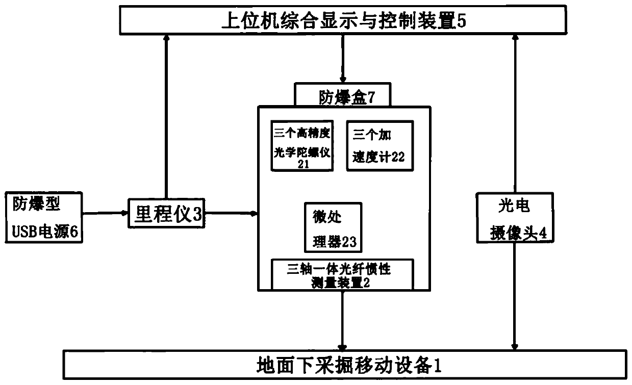
[0073] Kind of like figure 1 The shown inertial navigation and positioning system for underground mining mobile equipment includes a three-axis integrated optical fiber inertial measurement device 2. The three-axis integrated optical fiber inertial measurement device 2 consists of three high-precision optical gyroscopes 21, three accelerometers 22, and a microprocessor 器23 constitutes.

[0074] The three high-precision optical gyroscopes 21 are inertial-grade optical gyroscopes with a random drift stability of 0.01° / h. The use of high-precision inertial-grade optical gyroscopes not only meets the positioning accuracy requirements of underground mining mobile equipment, but is also conducive to cost Control, three accelerometers 22 are scale factor stability of 10 -4 An accelerometer of the order of mv / g. The accelerometer uses the geomagnetic line as a...


PUM


Abstract

Provides are an inertial navigation positioning system and positioning method for an underground mining mobile device. The system includes a three-axis integrated optical fiber inertial measurement device, an upper computer integrated display and control device, a power supply, an odometer and a photoelectric camera; the odometer is connected with the three-axis integrated optical fiber inertial measurement device and the upper computer integrated display and control device, and fixedly installed on a driving system of the underground mining mobile device, and the photoelectric camera is hinged to a hydraulic support, fixed to one side of the underground mining mobile device, through a fixing support, and conducts shooting in the running direction of the underground mining mobile device. The method includes the steps of adopting the odometer to measure position information of the underground mining mobile device, and correcting measurement errors of the inertial measurement device by an inertial navigation algorithm. On the premise without greatly increasing the cost, the navigation measurement accuracy, working efficiency and safety of the underground mining mobile device are greatly improved, and needs of unmanned operation can be met.

Description

Technical field [0001] The invention relates to navigation and positioning, in particular to an inertial navigation and positioning system and a positioning method for mobile equipment for underground mining and mining. Background technique [0002] Existing underground mining mobile equipment working face straightness measurement technologies, such as visual measurement, stroke measurement, etc., have visual blind spots, and the measurement data only reflects the displacement deviation of adjacent supports. Due to the special and complex environmental conditions under the ground, it is difficult for the mechanical or optical measurement systems usually used to accurately measure the movement trajectory of the mobile mining equipment under the ground, it is impossible to determine the position of the mobile mining equipment under the ground, and it cannot be controlled by automatic control. Set the purpose of the route. The use of inertial navigation to measure the movement traj...

Claims


Application Information

Patent Timeline
IPC IPC(8): G01C21/18G01C21/16G01C21/00G01C22/00G01C25/00
CPCG01C21/005G01C21/165G01C21/18G01C22/00G01C25/005
Inventor 邹健李磊贺媛甘助赵文李兰
Owner 深圳赛奥航空科技有限公司
Why Eureka
Try Eureka