A Lost Loss Prediction Method Based on Seismic Data
A technology of seismic data and prediction methods, applied in the directions of surveying, earthwork drilling and production, wellbore/well components, etc., can solve problems such as pressure excitation, formation pressure deficit, leakage channel, etc., and improve the efficiency and accuracy of identification , the effect of improving accuracy and efficiency
- Summary
- Abstract
- Description
- Claims
- Application Information
AI Technical Summary
Problems solved by technology
Method used
Image
Examples
Embodiment 1
[0043] As a preferred embodiment of the present invention, it discloses a lost circulation prediction method based on seismic data, the steps of which are as follows:
[0044]a. High resolution processing: processing conventional lower resolution seismic data into high resolution data;
[0045] b. Fine horizon correlation: Accurately pick up seismic horizons according to the usual seismic horizon correlation technology;
[0046] c. Automatic identification of folds: calculate the curvature of the formation along the seismic horizon, find folds, and judge the positive or negative of the curvature at the same time;
[0047] d. Judging the nature of folds: judging whether it is an anticline or a syncline according to the positive and negative changes of the curvature;
[0048] e. Extract the amplitude difference: calculate the amplitude difference in each direction within the scope of the target layer with the center of the slight fold;
[0049] f. Calculation of slight wrinkle...
Embodiment 2
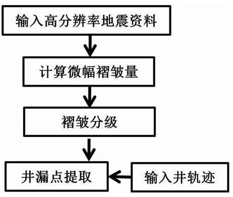
[0057] refer to figure 1 , as the best implementation mode of the present invention, its steps are:
[0058] a. High-resolution processing: process conventional lower-resolution seismic data into high-resolution data; if the resolution of seismic data is already high, this step can be ignored. The high-resolution processing method is arbitrary, but the resolution There should be a significant improvement.
[0059] b. Fine horizon correlation: Accurately pick seismic horizons according to the usual seismic horizon correlation technology; the picked seismic horizons should be on the same reflection feature point or geological interface, and the reflection feature points are peaks or troughs.
[0060] c. Automatic identification of folds: calculate the curvature of the formation along the seismic horizon, find folds, and judge the positive or negative of the curvature at the same time;
[0061] d. Judgment of the nature of folds: Judging whether it is an anticline or a syncline...
Embodiment 3
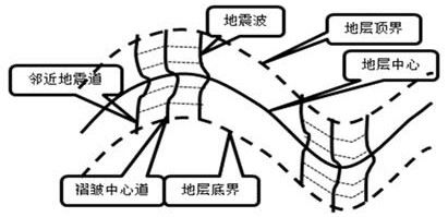
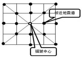
[0070] Specific application examples: Refer to 2 and 3 to clarify the principle of the specific calculation method.
[0071] figure 2 Contains an anticline and a syncline, just take the anticline as an example. The stratum center is determined, and the stratum thickness (time window length when the seismic section is in the time domain) is the range between the top and bottom boundaries of the stratum. According to the horizon data picked up by the formation center, the curvature can be calculated, folds can be found, and the positive and negative of the curvature (dorsal and syncline properties) can be obtained to determine the core of the fold and the seismic trace where the fold center is located—the central trace, and then from the upper Calculate the amplitude difference on both sides of the center track point by point. In actual calculation, also according to image 3 Calculate the amplitude difference between multiple traces in each direction of the central trace, a...
PUM
 Abstract
Description
Claims
Application Information
 - R&D
- Intellectual Property
- Life Sciences
- Materials
- Tech Scout
- Unparalleled Data Quality
- Higher Quality Content
- 60% Fewer Hallucinations
Browse by: Latest US Patents, China's latest patents, Technical Efficacy Thesaurus, Application Domain, Technology Topic, Popular Technical Reports.
© 2025 PatSnap. All rights reserved.Legal|Privacy policy|Modern Slavery Act Transparency Statement|Sitemap|About US| Contact US: help@patsnap.com


