Rapid land acquisition and demolition method based on ortho-image data

An orthophoto and data technology, applied in the field of rapid land acquisition and demolition, can solve the problems of inability to express the location relationship of the main project, increase the safety risk of technicians, and heavy workload of survey and measurement, so as to achieve efficient and important guiding significance for scheme optimization design and promotion value, the effect of flexible location

Pending Publication Date: 2019-11-22
CHINA RAILWAY ERJU 1ST ENG
View PDF4 Cites 2 Cited by
  • Summary
  • Abstract
  • Description
  • Claims
  • Application Information

AI Technical Summary

Problems solved by technology

However, this method has the following problems: the field survey and survey workload is large, the terrain accuracy of the survey is not enough, the position relationship with the main project cannot be expressed, and the safety risks of technicians are increased.

Method used


Image

  • Rapid land acquisition and demolition method based on ortho-image data

Examples


Embodiment

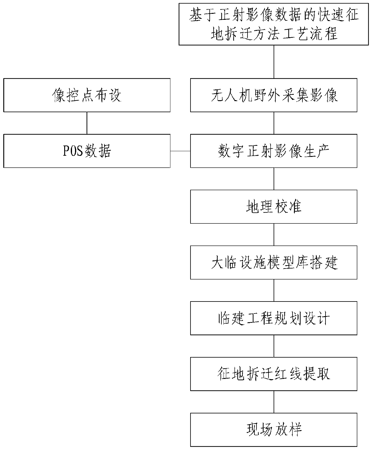
[0032] Refer to attached figure 1 , this embodiment provides a rapid land acquisition and demolition method based on orthophoto data, the specific method is as follows:

[0033] 1) UAV field image collection:

[0034] Combined with the weather and surrounding environment of the construction site, select the best flight time for aerial survey operations;

[0035] According to the size of the survey area, the image control points are arranged reasonably, and the image control points are arranged using 500mm*500mm black and white navigation marks as ground marks, and the coordinates of each image control point are measured;

[0036] Set aerial survey tasks, for cities or places with relatively flat terrain, where there are no high-voltage lines, large wireless base stations, and signal towers around, use automatic flight to collect images; for mountainous areas, use manual flight mode to collect.

[0037] 2) Orthophoto production

[0038] The orthophoto production of the prese...


PUM


Abstract

The invention provides a rapid land acquisition and demolition method based on ortho-image data. The technology that high-resolution and high-precision ortho-image data is produced based on the aerialsurvey technology of the unmanned aerial vehicle is researched. The land expropriation and demolition application method is simple in obtaining mode, short in production period, high in expressivity,safe and efficient, the geometrical position relation of a project station, a mixing station and a reinforcing steel bar processing factory in the actual geographical environment is truly and visually displayed, and the method has very high guiding significance for compiling and reporting of a temporary construction scheme. The land acquisition and removal period of the temporary construction project is shortened, the workload of technicians is reduced, and the construction efficiency of the temporary construction project is improved.

Description

technical field [0001] The present invention relates to a rapid land requisition and demolition method based on orthophoto image data, which is especially suitable for the land requisition and demolition of Dalin facilities in new construction projects. The design of Dalin facilities belongs to the field of construction engineering. Background technique [0002] At present, after winning the bid of the engineering project, the usual workflow for the construction of Dalin facilities is site survey, proposed site selection, on-site measurement, planning and design, and construction. The latest method in China is to quickly understand the surrounding environment of the main project on the Aowei map, select the area that is relatively close to the main line and relatively flat terrain, measure the length, width, and occupied area of ​​the area, and combine the temporary construction standards , to determine whether it can be used as a proposed site. Actual on-site survey, and ...

Claims


Application Information

Patent Timeline
Patent Type & Authority Applications(China)
IPC IPC(8): G06Q90/00G06F17/50G06T17/00G01C11/00G01B11/28G06Q50/08
CPCG06Q90/205G06T17/00G01C11/00G01B11/28G06Q50/08
Inventor 谢显龙文舟郭书涛胡光全何寿海崔宇梁旋钟杰李国栋米才标龚建伟原菊星周莉郭梅吴真元雍婷婷周磊熊峰唐佳俊袁恩培
Owner CHINA RAILWAY ERJU 1ST ENG
Why Eureka
Try Eureka