
Multi-group laser radar external parameter calibration system and method

A laser radar and calibration system technology, applied in the direction of radio wave measurement systems, instruments, etc., can solve the problems of sparse observation result information and the inability to detect the ground environment around the car body, etc., achieving low limitation, wide applicability, good The effect of robustness

Active Publication Date: 2019-12-20
SUN YAT SEN UNIV
View PDF10 Cites 29 Cited by
  • Summary
  • Abstract
  • Description
  • Claims
  • Application Information

AI Technical Summary

Problems solved by technology

[0003] In order to overcome the defects in the above-mentioned prior art that a single laser radar cannot detect the ground environment around the vehicle body above the vehicle body, and the observation result information is sparse, the present invention provides a multi-group laser radar external parameter calibration system and its method, which can complete multiple Group lidar external parameter calibration work to obtain high-precision calibration results

Method used


Image

  • Multi-group laser radar external parameter calibration system and method
  • Multi-group laser radar external parameter calibration system and method

Examples


Embodiment 1

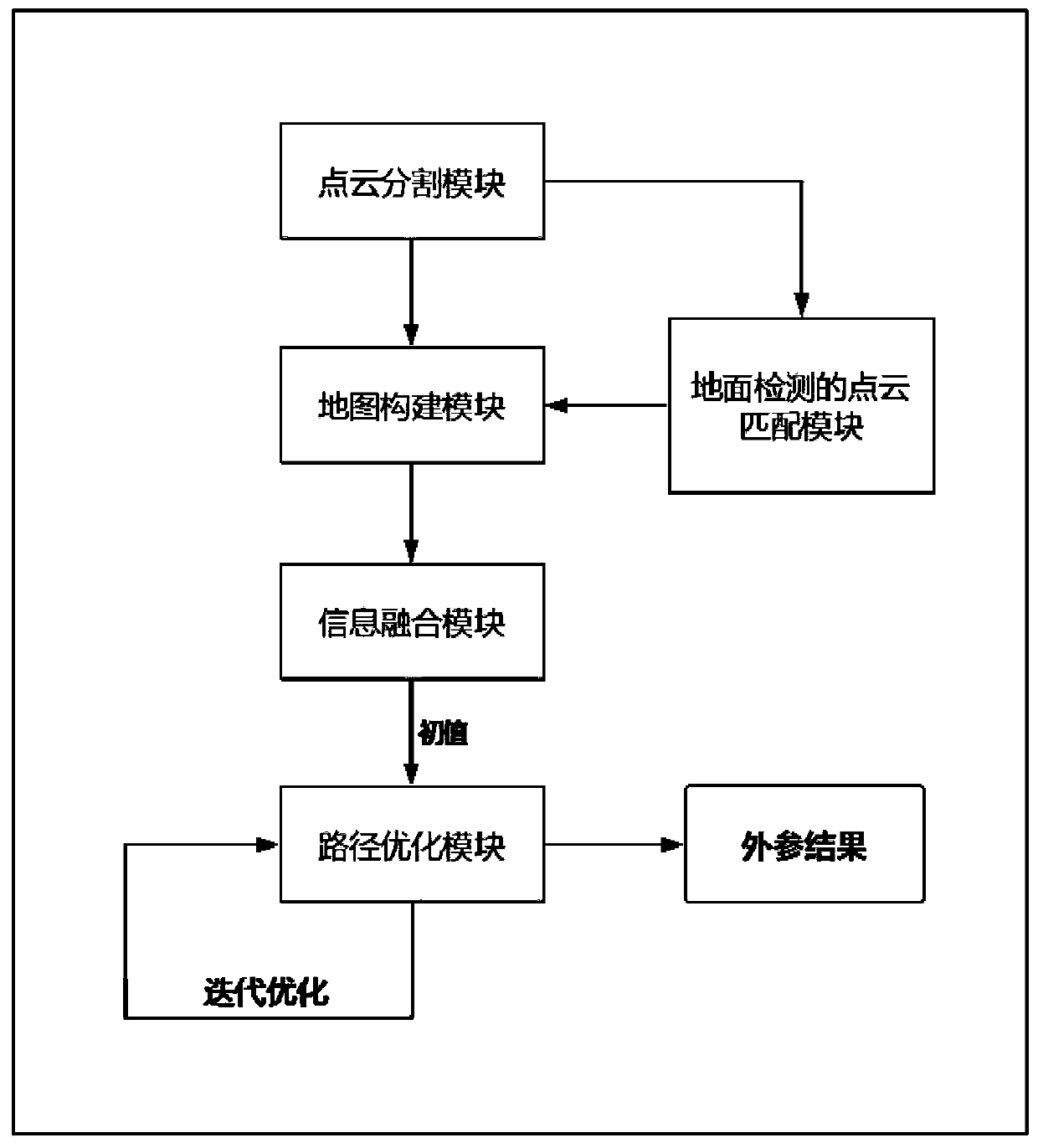
[0031] Such as figure 1 As shown, a multi-group lidar external parameter calibration system includes:

[0032] Point cloud segmentation module: the output of the laser radar is a three-dimensional laser point cloud, which contains the overall description of the external environment, including the road environment around the car body, obstacles, etc.; the point cloud segmentation module divides the three-dimensional laser point cloud into multiple categories , filter the noise points, and output the segmented semantic point cloud to the map building module and the ground detection point cloud matching module;

[0033] Point cloud matching module for ground detection: used to construct ground-based constraints, so that laser point cloud matching can be carried out on a relatively stable plane, point cloud matching uses semantic ICP (iterative closest point) The surrounding point cloud map registration strategy, the matching process uses the category information of the point clo...

Embodiment 2

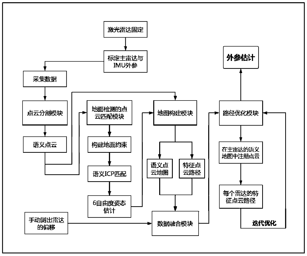
[0039] Such as figure 2 As shown, a multi-group laser radar external parameter calibration method specifically includes the following steps:

[0040] S1. The lidar is fixed on the car body, and the IMU is placed in the center of the car body. The positional relationship between multiple sets of lidars belongs to rigid body transformation. Select one of the lidars as the main radar, and set the others as auxiliary radars. Calibrate the main radar and IMU external reference;

[0041] S2. Select a suitable indoor and outdoor environment, and collect multiple sets of lidar and IMU data;

[0042] S3. Start the point cloud segmentation module offline, release the laser point cloud information to the point cloud matching module for ground detection, construct ground constraints and use the semantic ICP algorithm, and output the 6-degree-of-freedom attitude estimation of the registered point cloud;

[0043] S4. Obtain the 6-DOF attitude estimation of the semantic point cloud and th...


PUM


Abstract

The invention belongs to the technical field of laser radar, and particularly relates to a multi-group laser radar external parameter calibration system and method. The system comprises a point cloudsegmentation module, a ground detection point cloud matching module, a map construction module, an information fusion module and a path optimization module. Multi-group laser radar external parametercalibration work can be completed by the following steps: calculating point motion relation between a front frame and a rear frame of eacg laser radar by using context information of the laser radar within a period of time; adding poses provided by IMU (Inertial Measurement Unit) to remove accumulated radar motion distortion; and constructing a scene map in an area. The multi-group laser radar external parameter calibration system can accept conditions of a certain degree of radar view shielding, small common view or no common view, and can fully utilize mutual information among multiple radars after the calibration is completed, thereby view blind area is reduced and the capability of detecting external environment is improved. Compared with a traditional manual or single-frame calibration method, the multi-group laser radar external parameter calibration method has the advantages of wide applicability, simple installation and great improvements on robustness and accuracy of a calibration result.

Description

technical field [0001] The invention belongs to the technical field of laser radar, and more specifically relates to a multi-group laser radar external parameter calibration system and a method thereof. Background technique [0002] In recent years, the continuous advancement of lidar technology has provided a good sensor foundation for unmanned vehicles and intelligent mobile robots. Using lidar, the distance between the radar subject and the external environment and obstacles can be accurately measured, and the output point cloud can describe the three-dimensional space environment and can be displayed visually. LiDAR will not affect the normal and efficient operation of the device due to changes in light intensity and dynamic environment, but in actual working conditions, using only a single LiDAR may result in the loss of part of the field of view, resulting in blind spots in the field of view. Contents of the invention [0003] In order to overcome the defects in the...

Claims


Application Information

Patent Timeline
IPC IPC(8): G01S7/497
CPCG01S7/497
Inventor 邓梓枫陈龙
Owner SUN YAT SEN UNIV
Learn More