Urban streetscape 3D reconstruction method and system based on unmanned aerial vehicle and edge vehicle cooperation

A drone and urban technology, applied in the field of geographic information, can solve problems such as the inability to collect surface texture information of objects, complex lidar operation, and excessive weight of lidar range finders, so as to improve data acquisition and 3D reconstruction efficiency, Fast 3D reconstruction and iterative updates, reducing computational load and dependencies

Pending Publication Date: 2020-01-03
GUANGDONG UNIV OF TECH
View PDF5 Cites 23 Cited by
  • Summary
  • Abstract
  • Description
  • Claims
  • Application Information

AI Technical Summary

Problems solved by technology

However, due to viewing angle constraints, data on building roofs are often lost
At the same time, compared with the method of visual image modeling, the vehicle-based and airborne LiDAR technology cannot collect the texture information of the object surface, so it cannot reproduce the building in a more complete and realistic modeling.
Compared with the image visual reconstruction technology, the lidar range finder is not very popular due to its excessive weight and high price
Moreover, the operation of lidar is relatively more complicated.
[0014] (2) Although the airborne multi-image photography 3D reconstruction technology can achieve rapid reconstruction in large-scale urban 3D reconstruction, due to its shooting angle and height, the reconstruction effect of urban street scene details is not good. The DSM (Digital Surface Models) point cloud model is relatively sparse

Method used


Image

  • Urban streetscape 3D reconstruction method and system based on unmanned aerial vehicle and edge vehicle cooperation
  • Urban streetscape 3D reconstruction method and system based on unmanned aerial vehicle and edge vehicle cooperation
  • Urban streetscape 3D reconstruction method and system based on unmanned aerial vehicle and edge vehicle cooperation

Examples


Embodiment 1

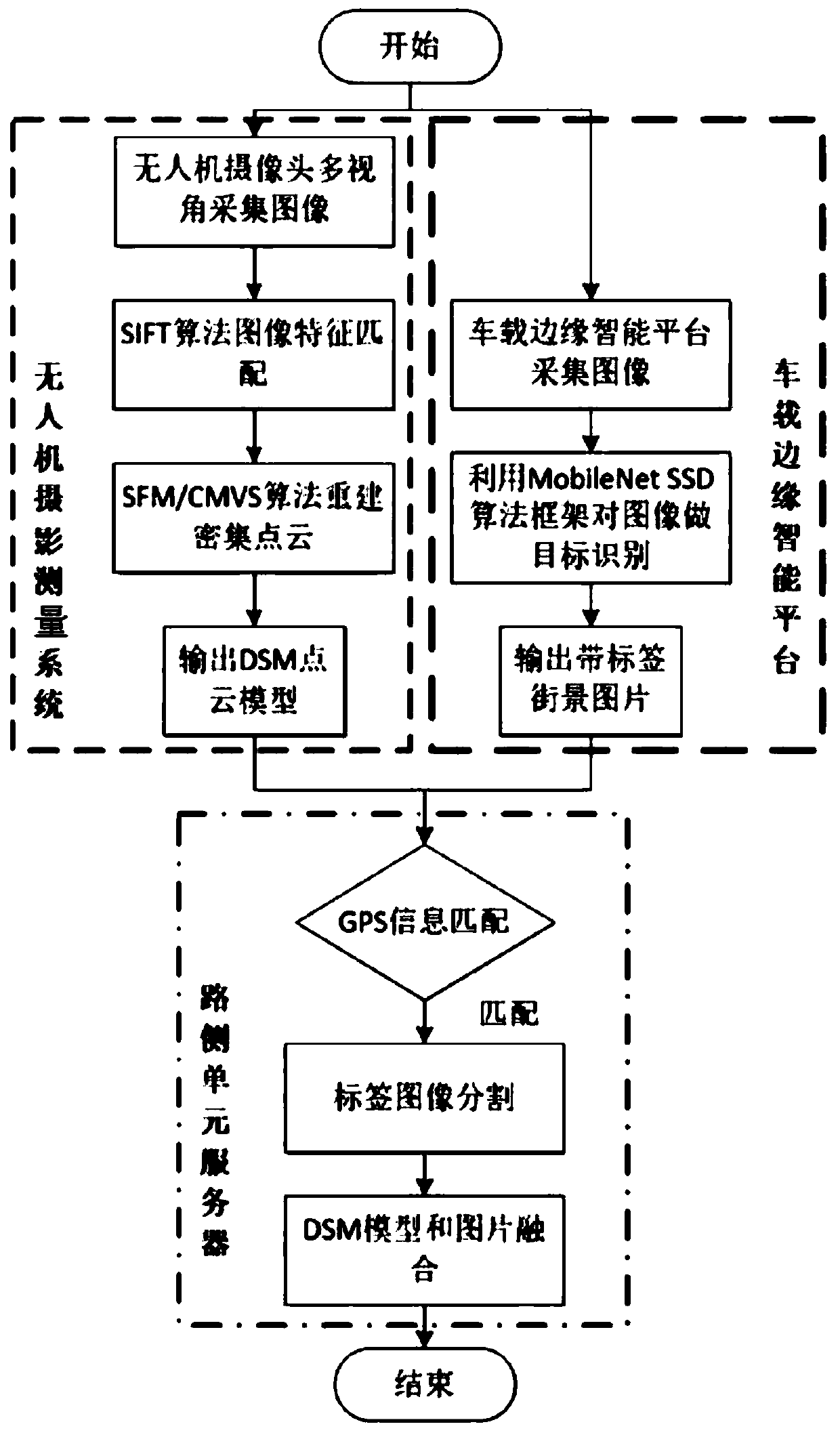
[0055] This embodiment provides a 3D urban street scene reconstruction method based on the coordination of drones and edge vehicles, such as figure 1 , including the following steps:

[0056] Use the camera mounted on the UAV to collect two-dimensional images of different perspectives of urban street scenes from different locations, and record the geographical location information along the way, use the GPU acceleration unit to generate a three-dimensional dense point cloud DSM model based on the two-dimensional images, and convert the three-dimensional dense point cloud The DSM model is output to the drive test unit server;

[0057] Use the camera mounted on the vehicle to collect image data of the city street view along the way, and record the geographic location information along the way, package the image data and geographic location information into a label image and output it to the drive test unit server;

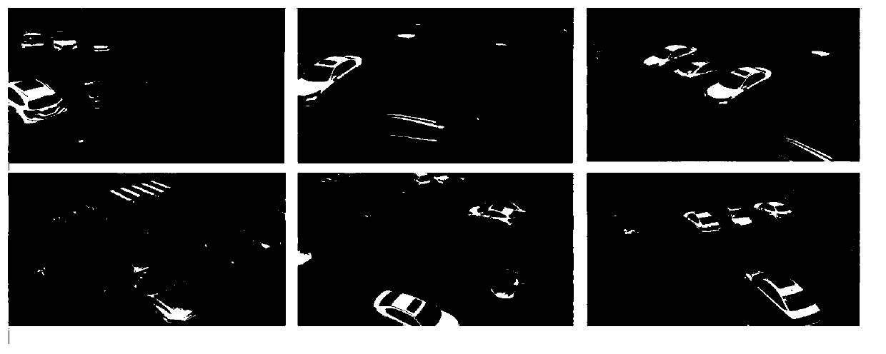
[0058] The roadside unit server performs semantic segmentatio...

Embodiment 2

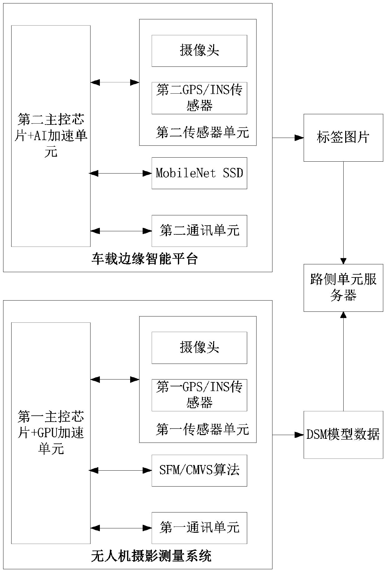
[0071] This embodiment provides a 3D urban street scene reconstruction system based on unmanned aerial vehicles and edge vehicles, such as figure 2 , including UAV photogrammetry system, vehicle-mounted edge intelligence platform and roadside unit server, among which:

[0072] The UAV photogrammetry system includes a UAV and a first main control chip, a GPU acceleration unit, a first sensor unit and a first communication unit on the UAV, and the main control chip receives different data collected by the sensor unit. The position collects two-dimensional images of different perspectives of the city street scene, and then controls the navigation and patrol route of the drone. The GPU unit generates a three-dimensional dense point cloud DSM model according to the two-dimensional image, and outputs the three-dimensional dense point cloud DSM model through the communication unit. to the drive test unit server;

[0073] The vehicle-mounted edge intelligence platform includes a fir...


PUM


Abstract

The invention provides an urban streetscape 3D reconstruction method based on unmanned aerial vehicle and edge vehicle cooperation. The functions of rapid and high-precision reconstruction, urban maprecognition and rapid updating iteration in large-scale urban streetscape 3D modeling are achieved. A distributed multi-node data acquisition network is formed in a mode that multiple vehicles at theedge end acquire streetscape pictures of a dense city area and transmit the streetscape pictures to a drive test unit server, so that multi-view shooting and large-range acquisition of road streetscape picture information are realized, the acquisition efficiency is improved, and the acquisition cost is reduced.

Description

technical field [0001] The present invention relates to the field of geographic information, and more specifically, to a method and system for 3D reconstruction of urban street scenes based on the cooperation of UAVs and edge vehicles. Background technique [0002] Digital Earth and Digital City have become important research directions in the field of geographic information. The technology of automatically generating accurate 3D models of cities is of great significance to robot navigation, computer mapping, virtual reality, and many visualization scenarios. It has great practical value in applications such as urban road planning, road damage assessment, and digital journeys. But modeling the appearance and behavior of urban spaces is a huge challenge. Because urban space is composed of a series of complex building structures, blocks and streets connected to each other, it belongs to a large-scale dense area. With the sharp increase in demand for 3D city map models in rec...

Claims


Application Information

Patent Timeline
Patent Type & Authority Applications(China)
IPC IPC(8): G06T17/00G06F16/29G06K9/62G06T7/11
CPCG06T17/00G06F16/29G06T7/11G06T2207/10012G06F18/241
Inventor 林华彪余荣张浩川
Owner GUANGDONG UNIV OF TECH
Why Eureka
Try Eureka