Three-dimensional visual optimization method for fan position of wind power plant

A technology for wind farms and wind turbines, which is applied in the field of three-dimensional visualization and optimization of wind turbine positions in wind farms. It can solve the problems of long construction period, heavy workload of on-site redundancy, and heavy workload of on-site coordination, so as to avoid safety risks and improve the efficiency and accuracy of optimization. The effect of shortening the overall construction period

Active Publication Date: 2020-01-10
POWERCHINA XIBEI ENG
View PDF2 Cites 9 Cited by
  • Summary
  • Abstract
  • Description
  • Claims
  • Application Information

AI Technical Summary

Problems solved by technology

Its disadvantages are: heavy on-site coordination workload, high safety risks for personnel and vehicles in complex traffic terrain, long construction period, low optimization efficiency, on-site confirmation makes designers have no sense of macro decision-making, heavy on-site redundant workload, and considerable time and economic costs

Method used


Image

  • Three-dimensional visual optimization method for fan position of wind power plant

Examples


Embodiment 1

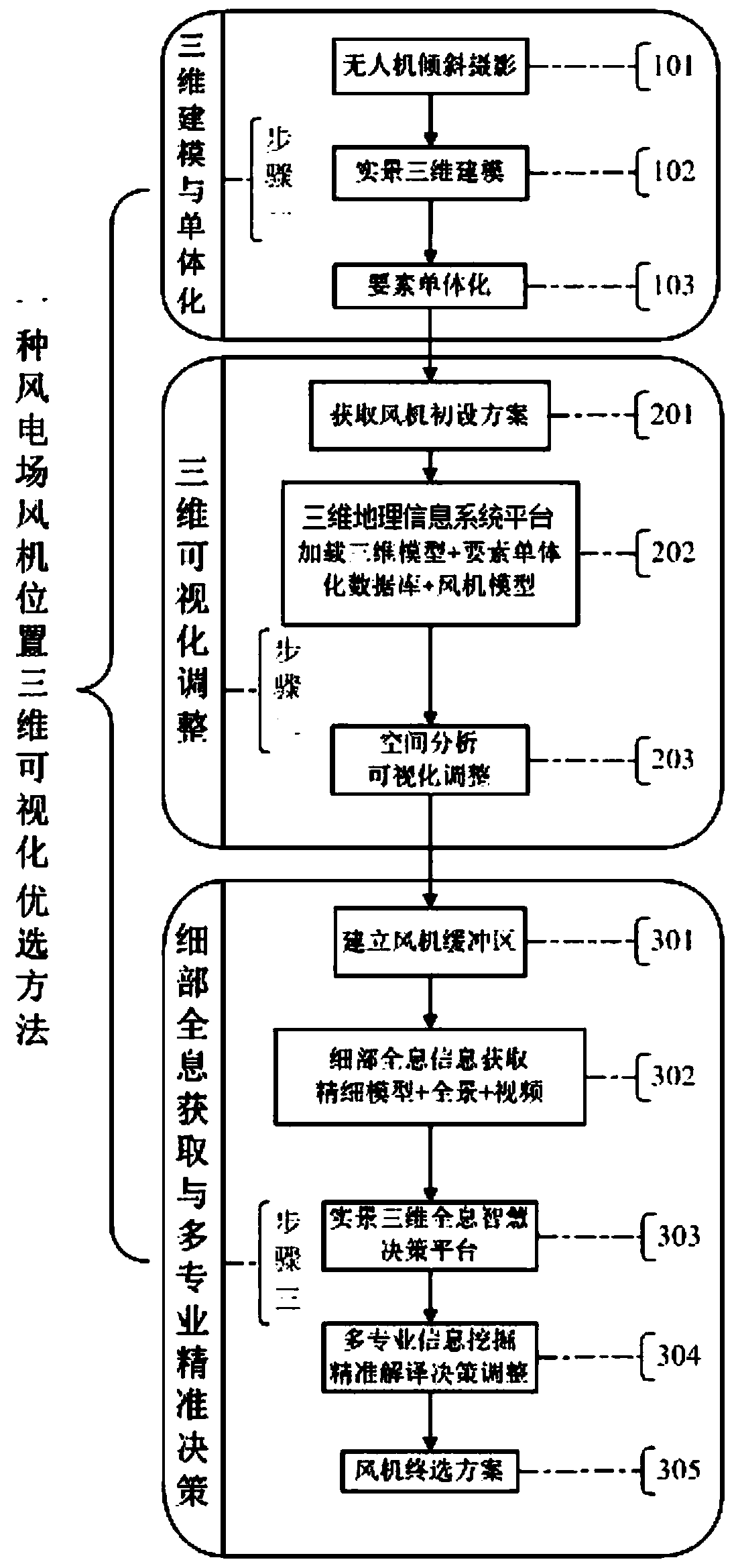
[0035] according to figure 1 A method for optimizing the three-dimensional visualization of the wind turbine position in a wind farm includes the following steps:

[0036] Step 1: Real-scene 3D model establishment and element singulation

[0037] Through drone photography, image data is obtained, and the 3D model of the real wind farm is established and the elements are singled out;

[0038] Step 2: Three-dimensional visualization adjustment of the preliminary design scheme of the wind turbine

[0039] Step 3: Holographic information mining and detailed precise decision-making

[0040] Through the spatial analysis function and remote sensing interpretation of geological conditions on the computer platform, relevant information is obtained, and in a visualized environment, the wind energy index, on-site and off-site roads and collector line layout are re-determined, and the final selection plan is output.

[0041] Preferably, the specific process of establishing the real-sce...

Embodiment 2

[0050] according to figure 1 The preferred method for three-dimensional visualization of wind turbine position in a wind farm is different from Embodiment 1 in that: the number of control points on the ground is not less than 1.2 times the number of square kilometers of the measured area; The resolution of UAV tilt photogrammetry is greater than or equal to 0.05 meters.

[0051] In actual use, a technical solution with a resolution greater than or equal to 0.05 meters for UAV tilt photogrammetry of wind farms is adopted, so that the obtained information meets the requirements and provides an effective basis for accurate decision-making.

Embodiment 3

[0053] according to figure 1 The preferred method for three-dimensional visualization of wind turbine position in a wind farm is different from the first embodiment in that: the real-scene three-dimensional model of the oblique photogrammetry is used for aerial triangulation calculation with the help of ground image control points or GNSS-PPK technology; The coordinate system adopted by the real scene 3D model described above is the wind farm foundation control measurement coordinate system.

[0054] In actual use, the topographic measurement accuracy of the wind farm is not lower than the scale specification requirement of 1:2000. The use of ground image control points to participate in the adjustment calculation can effectively improve the geometric accuracy of aerial triangulation. With the help of GNSS-PPK technology, the ground image control can be greatly reduced. The number of points and the geometric accuracy of aerial triangulation meet the geometric accuracy requirem...


PUM


Abstract

The invention belongs to the technical field of three-dimensional geographic information systems, and particularly relates to a three-dimensional visual optimization method for a fan position of a wind power plant. The three-dimensional visual optimization method comprises three steps of three-dimensional modeling and monomerization, three-dimensional visual adjustment, secondary detail holographic acquisition and multi-specialty accurate decision making, and establishes a three-dimensional visual optimization environment of the wind power plant by taking unmanned aerial vehicle surveying andmapping and a three-dimensional geographic information technology as support, so that the frequent field confirmation workload and time cost of professional designers of geology, wind resources, electromechanics, roads and the like can be reduced, and the overall construction period is shortened, and the safety risk is avoided, and the optimization efficiency and accuracy of the fan position are effectively improved.

Description

technical field [0001] The invention belongs to the technical field of three-dimensional geographic information systems, and in particular relates to a method for optimizing three-dimensional visualization of fan positions in wind farms. Background technique [0002] The traditional way to optimize the location of wind turbines in wind farms is: use traditional topographic map products of wind farms to make a two-dimensional design for the initial layout of wind turbines, and coordinate surveying and mapping, geology, wind resources, roads, electromechanical, wind turbine suppliers, and project construction representatives to go to the wind power plant at the same time Confirm and adjust the wind turbines one by one in the field. If it is unreasonable to return to the computer for evaluation later, you need to return to the site for confirmation. Sometimes more alternatives are needed to repeatedly confirm the final wind turbine location plan. Its disadvantages are: heavy on...

Claims


Application Information

Patent Timeline
Patent Type & Authority Applications(China)
IPC IPC(8): G06T17/05G06Q50/06
CPCG06T17/05G06Q50/06Y02A90/10
Inventor 尚海兴黄文钰张钊
Owner POWERCHINA XIBEI ENG
Why Eureka
Try Eureka