Autonomous optical navigation feature comprehensive optimization method for landing of extraterrestrial celestial body

An optical navigation and optimization method technology, applied in the field of deep space exploration, can solve the problems of initial deviation correction, inertial measurement unit random drift, difficulty in meeting high-precision navigation, etc., and achieve the effect of improving accuracy and ensuring stability

Active Publication Date: 2020-01-17
BEIJING INSTITUTE OF TECHNOLOGYGY
View PDF8 Cites 6 Cited by
  • Summary
  • Abstract
  • Description
  • Claims
  • Application Information

AI Technical Summary

Problems solved by technology

[0003] At present, the navigation method based on inertial measurement unit IMU dead position recursion is mainly used in the landing process, but this method cannot correct the initial deviation

Method used


Image

  • Autonomous optical navigation feature comprehensive optimization method for landing of extraterrestrial celestial body
  • Autonomous optical navigation feature comprehensive optimization method for landing of extraterrestrial celestial body
  • Autonomous optical navigation feature comprehensive optimization method for landing of extraterrestrial celestial body

Examples


Embodiment 1

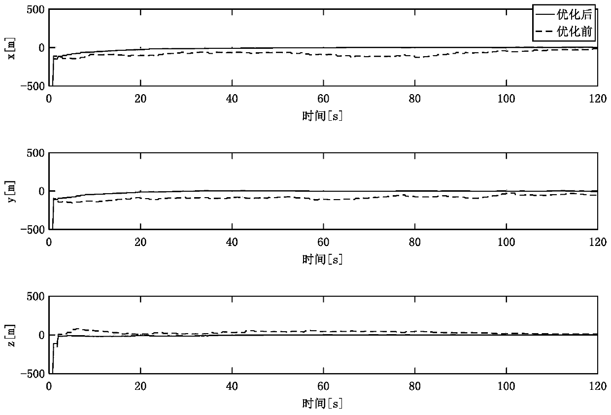
[0098] Under the Matlab environment, taking the Mars landing detection as the background, the mathematical simulation verification is carried out by using 10 characteristic points. It is assumed that the simulation ends when the lander reaches 100m above the landing point, and the landing time is 120s. The field of view of the navigation camera is 45°, the focal length is 14.6mm, and the measurement noise is 1 pixel. The IMU uses LN-200 with a sampling frequency of 50HZ.

[0099] The specific implementation method of this example is as follows:

[0100] The method for comprehensively optimizing the characteristics of autonomous optical navigation for extraterrestrial celestial body landing, the specific steps are as follows:

[0101] 1. A comprehensive optimization method for autonomous optical navigation features of extraterrestrial celestial body landing, including the following steps:

[0102] Step 1: Establish an autonomous visual navigation observation model based on f...

Embodiment 2

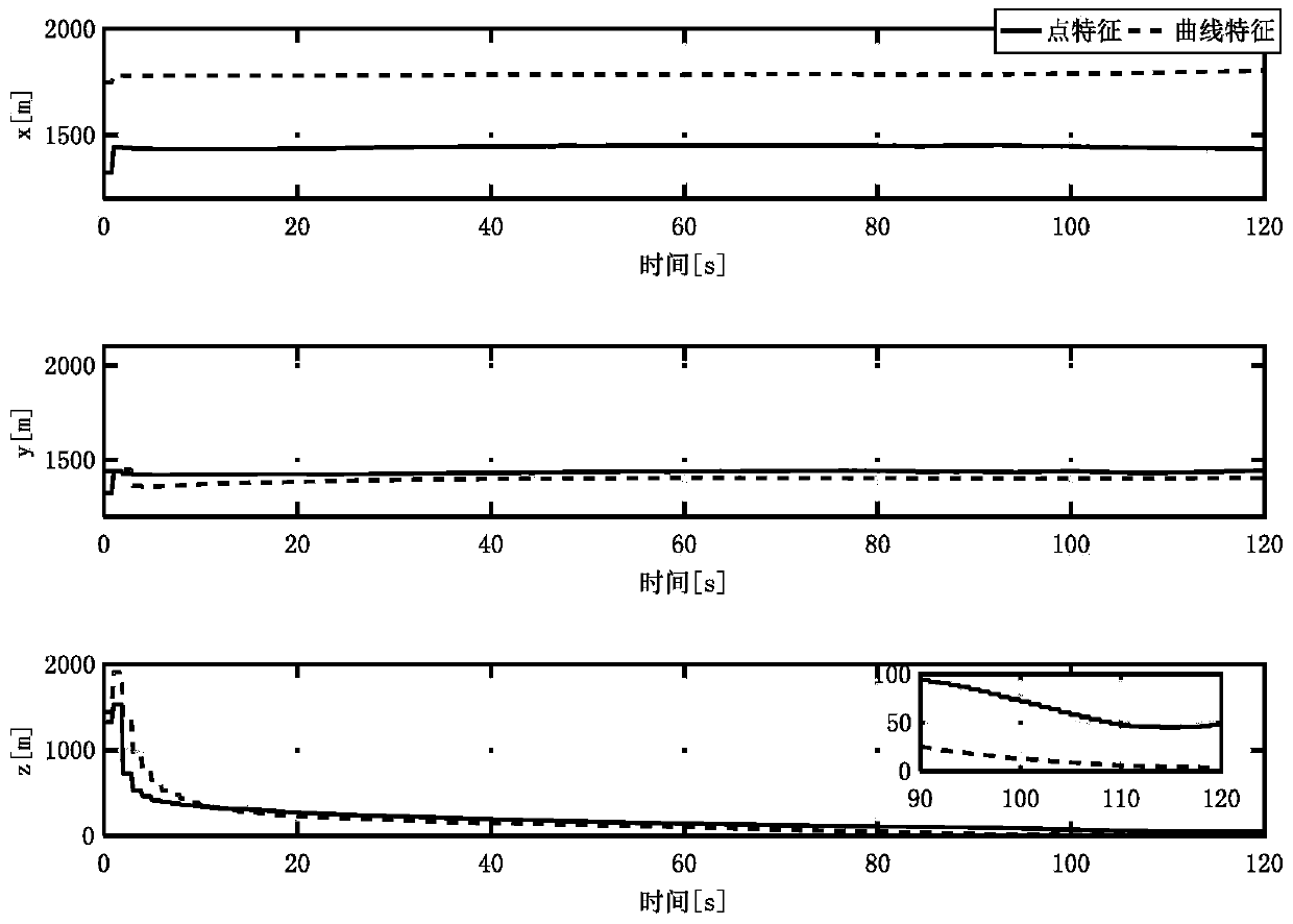
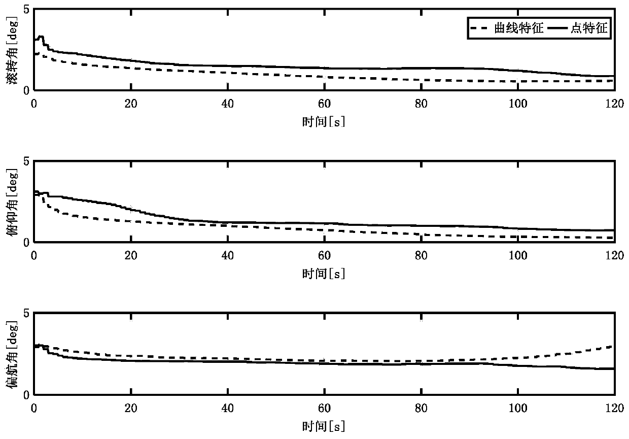
[0141] Under the Matlab environment, the mathematical simulation verification is carried out by using a curve and 10 characteristic points under the background of Mars landing detection. The landing environment is unknown, that is, the absolute position information of the navigation feature is unknown. It is assumed that the simulation ends when the lander reaches 100m above the landing point, and the landing time is 120s. The field of view of the navigation camera is 45°, the focal length is 14.6mm, and the measurement noise is 1 pixel. The IMU uses LN-200 with a sampling frequency of 50HZ.

[0142] The comprehensive optimization method for autonomous optical navigation features of extraterrestrial celestial body landing includes the following steps:

[0143] Step 1: Establish an autonomous visual navigation observation model based on feature points.


PUM


Abstract

The invention relates to an autonomous optical navigation feature comprehensive optimization method for landing of an extraterrestrial celestial body, and belongs to the technical field of deep spaceexploration. The method comprises the following steps: firstly, establishing observation equations of different geometric feature landmarks by using star catalogue image information; analyzing the observability degree and the estimation error lower limit of a navigation system by using a Fisher information matrix; on the basis, optimizing randomly distributed feature point landmarks by taking theobservability degree and the estimation error lower limit of the navigation system as evaluation indexes; and optimally selecting different navigation landmark feature points and curves, so that the precision of the navigation system is improved, and the stability of the navigation system is ensured. According to the method, the randomly distributed feature point landmarks are optimized by takingthe observability degree and the estimation error lower limit of the navigation system as the evaluation indexes, and the different navigation landmark feature points and curves are optimally selected, so that the precision of the navigation system is improved. The method is suitable for a planet landing task and is also suitable for a small celestial body landing task.

Description

technical field [0001] The invention relates to a comprehensive optimization method for autonomous optical navigation features of extraterrestrial celestial body landing, which belongs to the technical field of deep space detection. Background technique [0002] Landing detection and sampling return are the main development directions of deep space exploration in the future. Future small celestial body and Mars exploration missions require the probe to have the ability to land precisely in areas of high scientific value. However, the target celestial body is far away from the earth, and the communication delay is serious, which requires the detector to have the ability of autonomous navigation. At the same time, uncertainties such as insufficient prior information of the target celestial body environment and environmental disturbances put forward higher requirements for autonomous navigation systems. [0003] At present, the navigation method based on inertial measurement ...

Claims


Application Information

Patent Timeline
IPC IPC(8): G01C21/24G01C11/04G06F17/16
CPCG01C11/04G01C21/24G06F17/16
Inventor 崔平远高锡珍朱圣英徐瑞梁子璇
Owner BEIJING INSTITUTE OF TECHNOLOGYGY
Why Eureka
Try Eureka