Supercharge Your Innovation With Domain-Expert AI Agents!

Inverse weighted inversion method for sea surface wind direction based on interference imaging altimeter

A sea surface wind direction and interference imaging technology, which is applied in the direction of radio wave reflection/re-radiation, using re-radiation, measuring devices, etc., can solve the problem of 180°wind direction ambiguity and other problems

Active Publication Date: 2020-02-07
NAT SPACE SCI CENT CAS
View PDF13 Cites 7 Cited by
  • Summary
  • Abstract
  • Description
  • Claims
  • Application Information

AI Technical Summary

Problems solved by technology

But the wind direction obtained at this time still has 180° wind direction ambiguity

Method used


Image

  • Inverse weighted inversion method for sea surface wind direction based on interference imaging altimeter
  • Inverse weighted inversion method for sea surface wind direction based on interference imaging altimeter
  • Inverse weighted inversion method for sea surface wind direction based on interference imaging altimeter

Examples


Embodiment Construction

[0050] The technical solution of the present invention will be described in detail below in conjunction with the accompanying drawings.

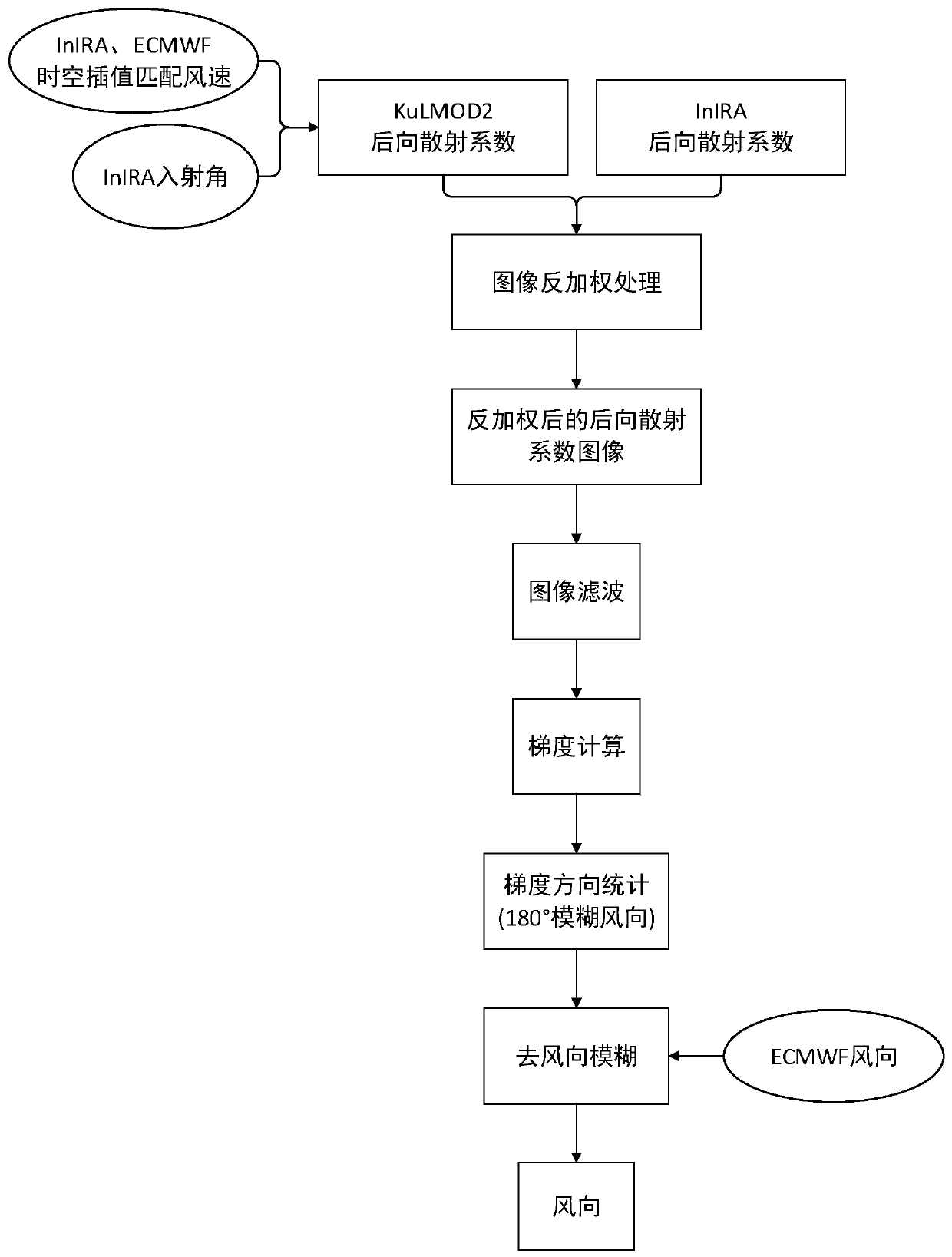
[0051] Such as figure 1 Shown, the present invention proposes a kind of sea surface wind direction anti-weighted inversion method based on interferometric imaging altimeter, and this method comprises:

[0052] Step 1) Spatio-temporal interpolation

[0053]Combined with the spatio-temporal position of InIRA (Interferometric Imaging Radar Altimeter, interferometric imaging altimeter), the European Center for Medium-Range Weather Forecasts (ECMWF) reanalyzed wind field data were interpolated spatio-temporally to obtain wind speed data matching InIRA;

[0054] Step 2) backscatter coefficient deweighting processing

[0055] Input the matched wind speed data and InIRA incident angle into the corresponding Ku-band backscatter coefficient model KuLMOD2 to obtain the deweighted backscatter coefficient image.

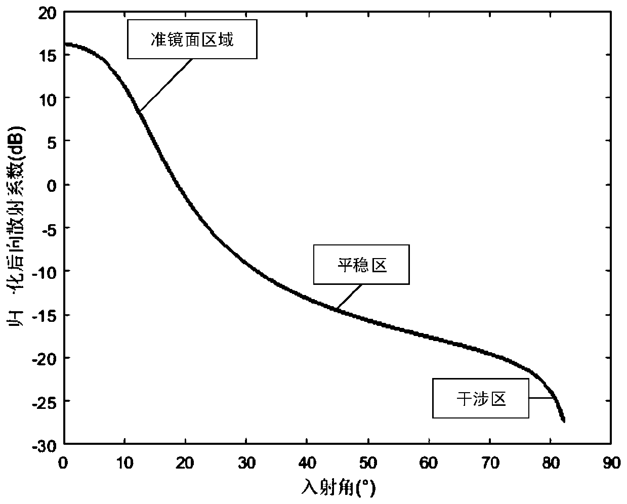
[0056] Sea surface backscatter coeffi...


PUM


Abstract

The invention discloses an inverse weighted inversion method for sea surface wind direction based on an interference imaging altimeter. The method comprises the following steps: selecting a sea surface backscattering coefficient image with wind fringes, performing space-time interpolation according to latitude and longitude coordinates of the image and reanalysis forecast wind speed data, and matching to obtain sea surface wind speed data; inputting an incident angle corresponding to the sea surface backscattering coefficient image and the sea surface wind speed data into a backscattering coefficient model to obtain a backscattering coefficient for inverse weighting, and performing inverse weighting processing on the sea surface backscattering coefficient image; performing filtering processing on the sea surface backscattering coefficient image after inverse weighting; calculating a gradient direction of the filtered image; performing sub-image division on the filtered image accordingto a wind direction detection scale, performing histogram statistics on all gradients of each sub-image, and selecting the gradient direction with the highest occurrence frequency as a wind directionwith 180-degree direction ambiguity; and removing the 180-degree ambiguity of the wind direction according to the reanalysis forecast data or buoy data to obtain the wind direction of each sub-image.

Description

technical field [0001] The invention relates to the field of radar signal processing and inversion, in particular to an inverse weighted inversion method for sea surface wind direction based on an interference imaging altimeter. Background technique [0002] Linear wind streaks are quasi-periodic linear bands appearing on synthetic aperture radar images, which are caused by rolling vortices in the atmospheric boundary layer, with a spatial scale of about 1-9 kilometers. There are two methods for extracting wind direction information from linear wind streaks in Synthetic Aperture Radar (SAR) images: Fourier transform method and local gradient method. [0003] The first method is carried out in the frequency domain. The two-dimensional wavenumber spectrum is obtained after two-dimensional Fourier transform of the selected sub-image. The vertical direction of the two-dimensional wavenumber spectrum peak line corresponds to the sea surface wind direction. The second method Taki...

Claims


Application Information

Patent Timeline
IPC IPC(8): G01S13/90G01S13/95
CPCG01S13/9023G01S13/95G01S13/882
Inventor 李果张云华董晓杨杰芳石晓进李东
Owner NAT SPACE SCI CENT CAS
Features
  • R&D
  • Intellectual Property
  • Life Sciences
  • Materials
  • Tech Scout
  • Unparalleled Data Quality
  • Higher Quality Content
  • 60% Fewer Hallucinations
Learn More