Irrigated farmland identification method based on remote sensing vegetation canopy moisture index

A vegetation index and vegetation canopy technology, applied in the field of agricultural remote sensing, can solve the problems that survey data cannot accurately and timely reflect the spatial distribution of irrigated areas and non-irrigated areas, it is difficult to control the number of coverage types, and the impact of accuracy, and achieve stable results Reliable, easy-to-operate, highly automatic results

Pending Publication Date: 2020-03-27
SUN YAT SEN UNIV +1
View PDF8 Cites 5 Cited by
  • Summary
  • Abstract
  • Description
  • Claims
  • Application Information

AI Technical Summary

Problems solved by technology

Therefore, the survey data cannot accurately and timely reflect the spatial distribution of irrigated and non-irrigated areas; (2) The United States Geological Survey (USGS) and the International Water Management Institute (IWMI) use unsupervised classification methods to analyze global irrigation and rainfed areas. Regions were classified to produce a Global Land Cover Type Map (GLCC) and a Global Irrigation Map (GIMA)
This method can still be used in the case of sparse local informatio...

Method used


Image

  • Irrigated farmland identification method based on remote sensing vegetation canopy moisture index
  • Irrigated farmland identification method based on remote sensing vegetation canopy moisture index
  • Irrigated farmland identification method based on remote sensing vegetation canopy moisture index

Examples


Embodiment 1

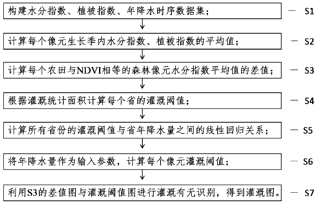
[0037] The Chinese irrigation area identification method based on the regression relationship between the remote sensing vegetation canopy moisture index and annual precipitation, taking the identification of Chinese irrigation areas as an example, the implementation process is as follows figure 1 As shown, it specifically includes the following steps:

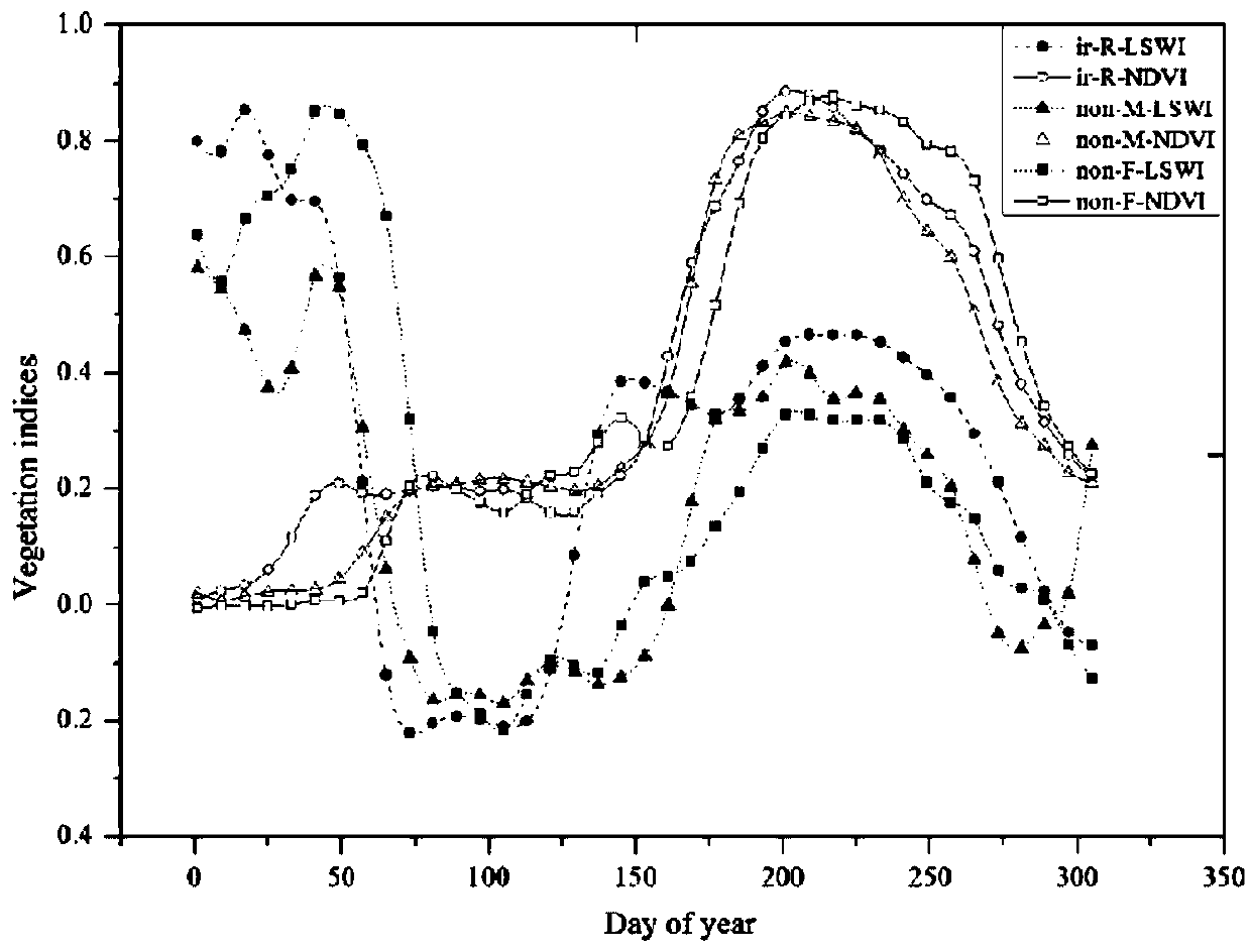
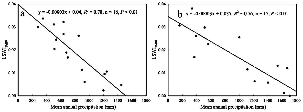
[0038] Step S1: Construct the water index, vegetation index, and annual precipitation time-series data set; first, calculate the water index LSWI (band2, band6) and vegetation index NDVI (band1, band2) based on the albedo products synthesized by MOD09A1 every 8 days. Using filtering and denoising methods such as Savitzky-Golay filter to smooth and denoise the original intra-year time series data set. A total of 46 time-series data sets within a year were obtained as the data basis for irrigation identification. According to the daily precipitation data of meteorological data stations in the past ten years, the annual average ...


PUM


Abstract

The invention discloses an irrigation farmland identification method based on a remote sensing vegetation canopy moisture index, and particularly relates to an irrigation identification method based on a regression relationship between a remote sensing vegetation canopy moisture index difference value of a farmland and a nearby forest and average annual precipitation. Due to the effect of rainfall, the irrigation threshold value of each area is reduced along with the increase of the average annual precipitation. Therefore, the determination of the irrigation threshold value can realize slidingvaluing in space, i.e., the smaller the irrigation threshold value is in the place with the larger average annual precipitation, the larger the irrigation threshold value is in the place with the smaller average annual precipitation. By designing a linear regression equation and fully utilizing the linear regression relationship between the difference value of the moisture indexes of the irrigated farmland pixel and the nearby forest pixel and the average annual precipitation, the change of the irrigation threshold in space can be realized, so that the identification of the irrigated farmlandis realized. The method has the characteristics of no dependence on priori knowledge, good robustness, high classification precision, strong recognition capability and the like.

Description

technical field [0001] The present invention relates to the technical field of agricultural remote sensing, and more specifically, relates to an irrigation identification method based on the regression relationship between the difference of moisture index of remote sensing vegetation canopy and annual precipitation in farmland and nearby forests. Background technique [0002] Accurate spatial distribution information of irrigated crops is an important basis for ensuring food security, and is crucial to the adjustment of agricultural industrial structure and the estimation of food production. Especially in arid regions, irrigation is an important condition for crop production. In China, only 40% of the total arable land is irrigated, but it produces 74% of the country's grain. Therefore, it is of great significance to develop a fast and accurate method for monitoring irrigation distribution. Due to the limitations of data availability and computing power, high-precision opt...

Claims


Application Information

Patent Timeline
IPC IPC(8): G06F17/18G06K9/00
CPCG06F17/18G06V20/188
Inventor 袁文平向昆仑
Owner SUN YAT SEN UNIV
Why Eureka
Try Eureka