Probability terrain estimation method based on uncertainty analysis

A technology of uncertainty and terrain, applied in the field of terrain reconstruction, can solve the problem that the terrain environment cannot be accurately perceived

Pending Publication Date: 2020-03-27
HARBIN INST OF TECH
View PDF4 Cites 7 Cited by
  • Summary
  • Abstract
  • Description
  • Claims
  • Application Information

AI Technical Summary

Problems solved by technology

[0004] In order to solve the challenging problem of being unable to accurately perceive the terrain environment in the event of sensor failure such as vision, the present invention provides a probabilistic terrain estimation method based on uncertainty analysis. The present invention provides the following technical solutions:

Method used


Image

  • Probability terrain estimation method based on uncertainty analysis
  • Probability terrain estimation method based on uncertainty analysis
  • Probability terrain estimation method based on uncertainty analysis

Examples


specific Embodiment 1

[0081] The present invention provides a probabilistic terrain estimation method based on uncertain analysis, the method is based on a patrol platform and sensors, and the patrol platform includes a patrol body and inherent sensors of the patrol platform, including the following steps:

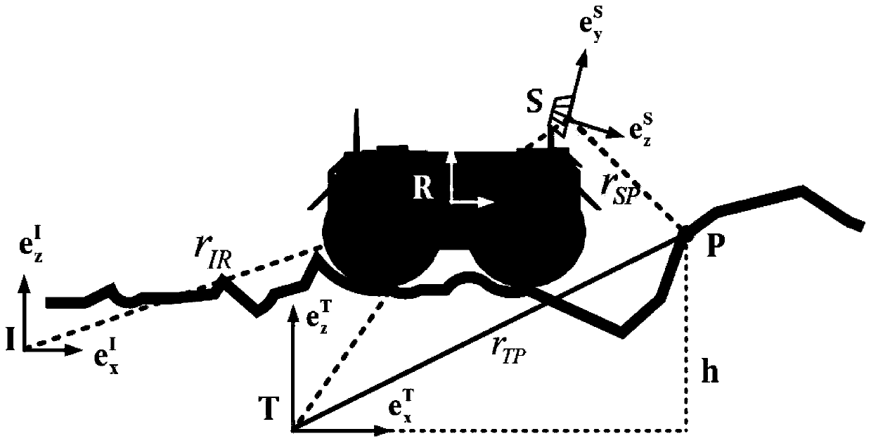
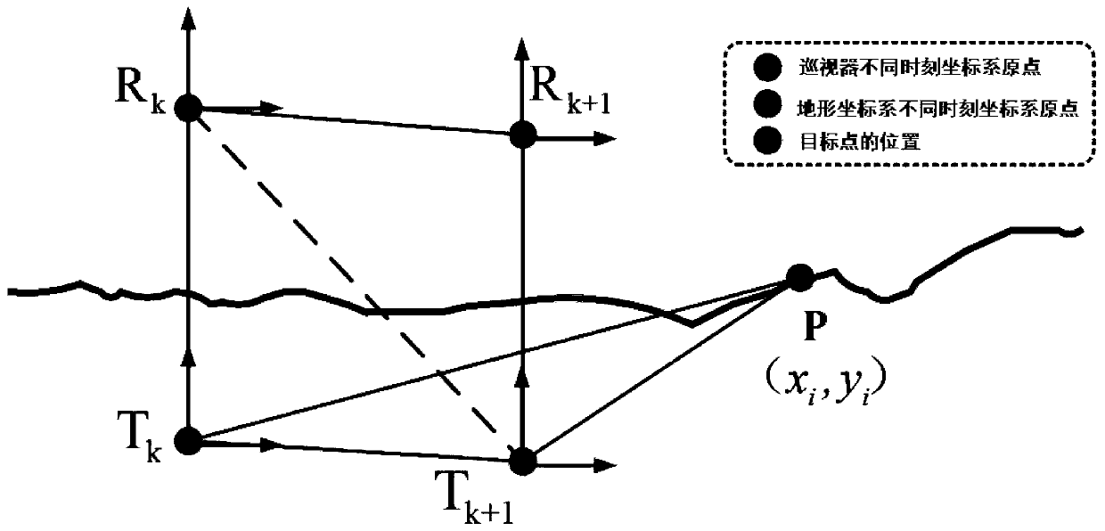
[0082] Step 1: Establish a patrol coordinate system, which includes an inertial coordinate system I, a terrain coordinate system T, a patrol platform body coordinate system R, and a sensor coordinate system S, and determine the covariance matrix of the patrol platform's pose at different times;

[0083] according to figure 1 As shown, the present invention defines four coordinate systems, which are inertial coordinate system I, terrain coordinate system T, patrol body coordinate system R, and sensor coordinate system S. Among them, the inertial coordinate system is fixed in the inertial space, the coordinate system of the patrol body is fixed at the center of mass of the patrol, and the coordin...


PUM


Abstract

The invention relates to a probability terrain estimation method based on uncertainty analysis. The method comprises the following steps: establishing an inspection coordinate system, and acquiring distance measurement data, vibration and gyroscope data when an inspection platform runs to a measurement point P based on the established inspection coordinate system; performing approximation processing on the estimation result by adopting Gaussian probability distribution; setting a point i in the grid to have new measurement update, and determining the influence of a noise error generated by themotion of the patrol platform on terrain fusion estimation; determining sensor position information and a terrain covariance estimated value based on the three-axis vibration tactile sensing unit andthe single-axis gyroscope; for the uncertainty terrain estimation of the measurement point corresponding to each of the terrains, enabling the measurement point p to correspond to the uncertainty terrain update of each of the terrains. The terrain estimation method provided by the invention has high terrain precision in two environments, the estimation error is within 2 cm, and the method has practical application value.

Description

technical field [0001] The invention relates to the technical field of terrain reconstruction, and is a probabilistic terrain estimation method based on uncertainty analysis. Background technique [0002] Research on terrain perception can be analyzed from three aspects, namely sensor selection, algorithm and application. Among them, the use of sensors has gradually developed from vision and lidar in the early days to multi-sensor fusion; algorithms have gradually developed from triangulation and filter optimization to machine learning and biological inspiration; applications have gradually evolved from terrain estimation at the beginning to Modeling of geographic environments, development of scientific attribute detection. The general trend is still more inclined to multi-sensor fusion terrain estimation that does not rely on external information. In 2007, based on a large number of pictures taken on orbit and during patrolling, Olson realized high-precision frame-to-fram...

Claims


Application Information

Patent Timeline
Patent Type & Authority Applications(China)
IPC IPC(8): G06F30/20G06F17/16G01D21/02
CPCG01D21/02G06F17/16
Inventor 白成超郭继峰郑红星刘天航
Owner HARBIN INST OF TECH
Why Eureka
Try Eureka