
Low-power-consumption satellite navigation mobile acquisition station network system and construction method

A mobile collection station and satellite navigation technology, applied in the field of satellite navigation, can solve the problems of low spatial correlation of observation environment observation environment, evaluation results cannot be directly connected to users in time for users to use, and high maintenance costs, so as to achieve optimal calculation The effect of efficiency and positioning accuracy

Pending Publication Date: 2020-04-10
长沙金维信息技术有限公司
View PDF8 Cites 0 Cited by
  • Summary
  • Abstract
  • Description
  • Claims
  • Application Information

AI Technical Summary

Problems solved by technology

The existing satellite navigation monitoring and evaluation system still has the following limitations: (1) It is mainly used to monitor the overall operation status of the satellite navigation system, and is not suitable for flexible application scenarios of observation data for a large number of users; (2) The network coverage of the collection station is limited, The spatial correlation between its observation environment and the user’s observation environment is low. If a large number of collection stations need to be built according to the existing plan to expand the monitoring coverage, the maintenance cost will be high; Handle pressure and deliver high pressure
Therefore, there is a certain delay in transmission and processing, and the evaluation results cannot be directly accessed by users in a timely manner for users to use. Most monitoring and evaluation services and products need to be downloaded from the website for post-calculation comparison and analysis, and the time correlation of observation data products Low

Method used


Image

  • Low-power-consumption satellite navigation mobile acquisition station network system and construction method
  • Low-power-consumption satellite navigation mobile acquisition station network system and construction method
  • Low-power-consumption satellite navigation mobile acquisition station network system and construction method

Examples


Embodiment Construction

[0054] The present invention will be further described below in conjunction with specific embodiment and accompanying drawing:

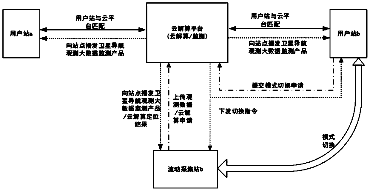
[0055] figure 1 It is a schematic diagram of the principle of the low-power satellite navigation mobile collection station network system in this embodiment. The system includes a site and a cloud solution platform. computing function; the cloud computing platform is connected to multiple sites, and the cloud computing platform has monitoring and positioning computing functions;

[0056] User station: According to the quality monitoring information of satellite navigation space-time observation big data broadcasted by the cloud solution platform, abnormal data is eliminated, the quality of observation data is improved, the efficiency of calculation and positioning accuracy are optimized, and the reliability of positioning is enhanced; after the site is connected to the network system, The default initial mode is the user station mode, and the user s...


PUM


Abstract

The invention discloses a low-power-consumption satellite navigation mobile acquisition station network system and a construction method. The system comprises a station and a cloud resolving platform.The station comprises two working modes of a user station and a mobile acquisition station, and a positioning resolving function is not needed. The cloud resolving platform is connected with a plurality of stations and has monitoring and positioning resolving functions. On the basis that a user station and a mobile acquisition station can be dynamically switched and satellite navigation space-time observation big data monitoring information is generated, based on a cloud resolving mode, the mobile acquisition station can send observation data to the cloud resolving platform, positioning resolving is achieved on the cloud resolving platform, and resolving efficiency and positioning reliability are optimized through quality monitoring information of satellite navigation space-time observation big data. And if other mobile acquisition stations with high-precision positioning capability exist in the same area, high-precision positioning of the mobile acquisition station applying for cloudcalculation can be completed through relative positioning, and services can be provided for other mobile acquisition stations applying for cloud calculation.

Description

technical field [0001] The invention belongs to the technical field of satellite navigation, and in particular relates to a low-power consumption satellite navigation mobile collection station network system and a construction method. Background technique [0002] Under the background of the rapid development of satellite navigation technology and increasingly fierce competition, the performance of satellite navigation system has gradually attracted widespread attention. The performance of satellite navigation system directly affects its operation and service level. The main goal of satellite navigation monitoring and evaluation is to establish a global near-real-time tracking network with full arc and multiple coverage of navigation satellites, and an information service platform with data collection, storage, analysis, management, and release functions to monitor the operation of the global satellite navigation system. The status and main performance indicators are monitor...

Claims


Application Information

Patent Timeline
IPC IPC(8): G01S19/03G01S19/02
CPCG01S19/03G01S19/02
Inventor 刘旭华涂传亮蒋云翔庞浩冷如松张珊田震华刘彦叶军
Owner 长沙金维信息技术有限公司
Features
  • Generate Ideas
  • Intellectual Property
  • Life Sciences
  • Materials
  • Tech Scout
  • Unparalleled Data Quality
  • Higher Quality Content
  • 60% Fewer Hallucinations
Learn More