Method for generating clear sky radiation product of wind cloud stationary satellite

A static satellite and clear sky technology, applied in the field of satellite meteorology, can solve the problems of excessive data transmission, numerical forecast calculation, and low efficiency of satellite data use

Active Publication Date: 2020-04-24
NAT SATELLITE METEOROLOGICAL CENT +4
View PDF5 Cites 2 Cited by
  • Summary
  • Abstract
  • Description
  • Claims
  • Application Information

AI Technical Summary

Problems solved by technology

my country's geostationary satellites have not developed CSR products. Assimilating their radiation data requires reading the original data. In the preprocessing stage, sparse data and data with excessive zenith angle...

Method used


Image

  • Method for generating clear sky radiation product of wind cloud stationary satellite
  • Method for generating clear sky radiation product of wind cloud stationary satellite
  • Method for generating clear sky radiation product of wind cloud stationary satellite

Examples


Embodiment Construction

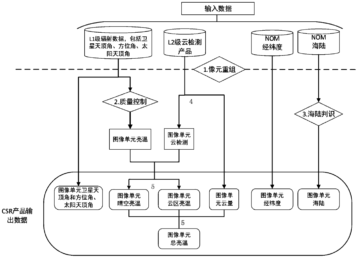
[0030] Such as figure 1 Shown: the generation method of the clear-sky radiation product of the Fengyun geostationary satellite of the present embodiment, the production steps of the clear-sky radiation product of the Fengyun satellite are as follows:

[0031] (1) Reorganize the nominal map of the geostationary satellite in the form of 3*3 pixels. The reorganized whole is called the image unit (NOM). The resolution of the sub-satellite point of the image unit is 15km. The vertex angle, satellite azimuth angle and solar zenith angle are represented by the longitude and latitude, satellite zenith angle, satellite azimuth angle and solar zenith angle of the central pixel. The positioning method represented by the central pixel is more accurate and easy to calculate;

[0032] (2) Set the threshold value of the zenith angle of the image unit for quality control, remove the image unit with a zenith angle greater than 60°, and remove the image unit with an excessive zenith angle, so a...


PUM


Abstract

The invention relates to the technical field of satellite meteorology, in particular to a method for generating a clear sky radiation product of a wind cloud stationary satellite, which comprises thefollowing steps: recombining a stationary satellite nominal map in a 3*3 pixel mode; performing quality control on an image unit; performing sea-land judgment on the image unit; judging a clear sky pixel and a cloudy pixel, and obtaining cloud amount information; and calculating the clear sky brightness temperature, cloud area brightness temperature and total brightness temperature. By means of the process, the method for generating a clear sky radiation product of a wind cloud stationary satellite is provided, a produced clear sky radiation product can be directly used for a numerical weatherprediction mode, and the use efficiency of wind cloud satellite data is improved.

Description

technical field [0001] The invention relates to the technical field of satellite meteorology, in particular to a method for generating clear sky radiation products of Fengyun geostationary satellites. Background technique [0002] Geostationary meteorological satellites can provide information on water vapor and clouds on the surface and in the atmosphere in the middle and low latitudes with high time resolution, which is very important for Numerical Weather Prediction (NWP). At present, the main geostationary satellites in orbit for meteorological services in the world include the Meteosat Second Generation (MSG) series of the European Organization for the Exploitation of Meteorological Satellites (EUMETSAT), the US National Oceanic and The geostationary operational environmental satellites (Geostationary Operational Environmental Satellites, GOES) series of the Atmospheric Administration, the sunflower satellite (Himawar) series of the Satellite Meteorological Center of th...

Claims


Application Information

Patent Timeline
IPC IPC(8): G01W1/10G06T7/00G06T7/136
CPCG01W1/10G06T7/0002G06T2207/20221G06T2207/30168G06T2207/30192G06T7/136
Inventor 于天雷马刚陆风张晓虎
Owner NAT SATELLITE METEOROLOGICAL CENT
Why Eureka
Try Eureka