Geotechnical engineering inclinometry method and device based on shape memory material

A memory material, geotechnical engineering technology, applied in measuring devices, measuring inclination, mapping and navigation, etc., can solve the problem of lack of monitoring ability of true three-dimensional horizontal displacement characteristics of rock and soil, inability to operate instruments correctly, time-consuming and laborious data collection, etc. It can meet the needs of large deformation monitoring, reduce the workload of monitoring operations, and reduce the cost of production and operation.

Active Publication Date: 2020-05-08
SHANGHAI CONSTRUCTION GROUP
View PDF5 Cites 0 Cited by
  • Summary
  • Abstract
  • Description
  • Claims
  • Application Information

AI Technical Summary

Problems solved by technology

[0004] 1. The workload is large; data collection is time-consuming and laborious. A single measuring hole generally collects a data every 0.5m or 1.0m (limited by the length of the sensor probe). At the same time, due to the offset error and zero drift error of the sensor probe, The single data of a single measurement hole needs to collect two sets of data for positive measurement and reverse measurement for error elimination
[0005] 2. The measuring range is limited: if the rock and soil body undergoes a large deformation, the inclinometer pipe will produce excessive curvature, which will cause the sensor head to be unable to pass freely, resulting in "shearing" of the inclinometer hole. At present, although it is possible to increase the inner diameter of the inclinometer pipe To reduce the probability of the measuring tube being "cut", but increasing the inner diameter of the measuring hole will also have a "reinforcement effect" on the original formation or cause greater "defects" to the pile foundation and the enclosure structure, which will have unnecessary effects and make the monitoring Distortion occurs
[0006] 3. High failure rate: The inclinometer tube is easily blocked or damaged by debris on the construction site, and the guide groove is easily blocked by the combination of sediment, dust, water vapor, etc., resulting in restricted sliding of the guide wheel. Once these failures occur, the Difficult to check, and even cause the inclinometer tube to be scrapped directly
[0007] 4. There are many error factors: the inclinometer itself has three kinds of instrument errors: offset error, zero drift error and rotation error; the inclinometer conduit will produce conduit distortion errors during the manufacturing and installation process; during the observation process, the instrument system is affected by the environment. The influence of temperature and humidity will cause environmental errors; due to the observer's technical ability, work habits and sense of responsibility, it will cause human errors if he cannot operate the instrument correctly, make observation errors, read wrong numbers, and remember wrong values; in data processing In the process, calculation errors will occur due to improper selection of calculated reference values ​​and assumed fixed points, etc.
[0008] 5. Discrete and non-continuous data: It belongs to the measurement of equidistant discrete incremental method, the length of the measuring head determines the dispersion of monitoring data, which cannot accurately and completely describe the deformation characteristics of the formation
[0009] 6. Single direction of inclination measurement: At present, it is generally only possible to measure displacement curves in two directions, which belongs to in-plane measurement. It is suitable for situations with obvious plane deformation characteristics such as narrow and long foundation pits, but it is true for rock and soil in complex situations. Lack of monitoring capabilities for displacement characteristics;
[0010] 7. The degree of automation is low; due to the fact that there are too many human factors and accidental factors in the use of this monitoring method, there are certain difficulties in the realization of automated inclinometers based on this method

Method used


Image

  • Geotechnical engineering inclinometry method and device based on shape memory material
  • Geotechnical engineering inclinometry method and device based on shape memory material
  • Geotechnical engineering inclinometry method and device based on shape memory material

Examples


Embodiment 1

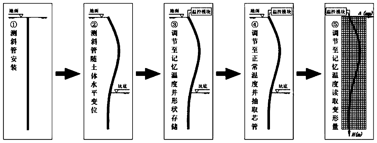
[0047] Combine below Figure 1 to Figure 7 , which describes in detail the geotechnical engineering inclination measuring method and device based on the shape memory material of the present invention.

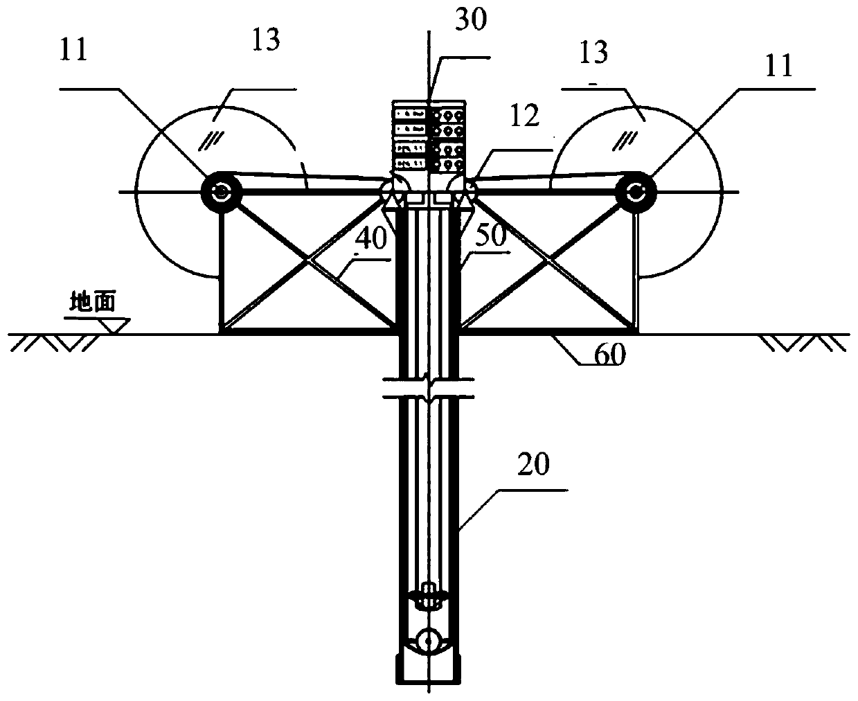
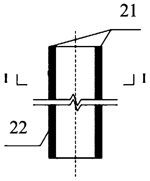
[0048] Please refer to Figure 2 to Figure 7 , a geotechnical engineering inclinometer device based on shape memory materials, comprising a measuring strip, a core tube 22, an inclinometer tube 20, a shape-forming condition control module 30, and a drive unit, and the inclinometer tube 20 is pre-embedded before the monitoring work is carried out In the formation, the inner wall of the inclinometer pipe 20 is provided with a temperature-controlled chamber 22, and the temperature-controlled chamber 22 is provided with a measuring strip cavity 23, which is used for placing a measuring strip made of shape memory material. The measuring strip is wrapped in the core tube 22, which can adjust the forming conditions of the measuring strip. The core tube 22 is built in the inclinometer...


PUM


Abstract

The invention relates to a geotechnical engineering inclinometry method and a geotechnical engineering inclinometry device based on a shape memory material, which belong to the technical field of geotechnical engineering monitoring. The geotechnical engineering inclinometry method and the geotechnical engineering inclinometry device mainly utilize the shape memory effect of a shape memory materialunder a specific shaping condition, put a measuring strip made of the shape memory material into an inclinometer tube, ensure that the measuring strip can generate cooperative free deformation with surrounding rock-soil bodies, apply forming conditions to complete deformation recording, remove the forming conditions and extract the measuring strip when the measuring strip is recovered to a conventional state, and reapply the forming conditions to directly read a deformation numerical value of a memorized shape by comparing with scales. According to the geotechnical engineering inclinometry method, the workload of monitoring operation can be greatly reduced; and the large deformation monitoring requirement of geotechnical engineering is effectively met. The geotechnical engineering inclinometry device comprises a driving part, the inclinometer tube and a shaping condition control module, wherein the measuring strip is made of the shape memory material, the measuring strip is wrapped ina core tube, the core tube can adjust the shaping condition of the measuring strip, and the core tube is arranged in the inclinometer tube and deforms synchronously with the inclinometer tube.

Description

technical field [0001] The invention relates to the technical field of geotechnical engineering monitoring, in particular to a geotechnical engineering inclination measuring method and device based on a shape memory material. Background technique [0002] Inclinometer technology is widely used in geotechnical engineering such as foundation pits, pile foundations, and slopes, providing powerful monitoring basis and technical support for construction safety management, quality control, and surrounding environmental protection. At present, sliding inclinometers are usually used for horizontal displacement monitoring in geotechnical engineering. This type of inclinometer is mainly composed of four parts: inclinometer tube, probe, cable and host. [0003] The working principle of the sliding inclinometer: in engineering application, the inclinometer tube is first embedded in the soil (pile, wall), and after the deformation of the soil (pile, wall), the entire inclinometer tube al...

Claims


Application Information

Patent Timeline
Patent Type & Authority Applications(China)
IPC IPC(8): G01C9/00G01C9/02
CPCG01C9/00G01C9/02
Inventor 周泉吉龚剑房霆宸张阿晋赵一鸣贺洪煜孙婷梅坤
Owner SHANGHAI CONSTRUCTION GROUP
Why Eureka
Try Eureka