Method and system for estimating sea ice thickness distribution based on least squares adjustment

A technique of least squares and thickness distribution, applied in design optimization/simulation, etc., can solve problems such as inaccurate acquisition, difficulty in obtaining parameter values, uncertainty of sea ice thickness estimation results, etc., to avoid uncertainty and improve reliability effect

Inactive Publication Date: 2021-04-16
WUHAN UNIV
View PDF1 Cites 0 Cited by
  • Summary
  • Abstract
  • Description
  • Claims
  • Application Information

AI Technical Summary

Problems solved by technology

However, limited by the special geographical location and climatic conditions of the sea ice area, these parameters cannot be obtained accurately, and it is difficult to obtain parameter values ​​synchronized with satellite altimetry
The selection of these parameter values ​​brings great uncertainty to the sea ice thickness estimation results.

Method used


Image

  • Method and system for estimating sea ice thickness distribution based on least squares adjustment
  • Method and system for estimating sea ice thickness distribution based on least squares adjustment
  • Method and system for estimating sea ice thickness distribution based on least squares adjustment

Examples


Embodiment Construction

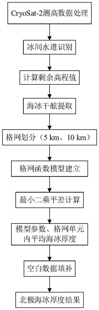
[0053] The present invention will be further described in detail below in conjunction with the accompanying drawings and embodiments.

[0054] A method for estimating sea ice thickness distribution based on least squares adjustment provided by an embodiment of the present invention, the process is as follows figure 1 Shown:

[0055] Step 1, satellite altimetry data processing

[0056] Embodiment Based on the CryoSat-2 radar altimetry data, taking the Arctic sea ice area as an example, the longitude (lon), latitude (lat), elevation (h), average Sea level height (h ssh ), orbital number (orb), pulse peak value (PP) and pulse cumulative standard deviation (SSD), etc.;

[0057] Step 2, sea ice freeboard height extraction

[0058] Step 2.1, according to the characteristic parameters of the echo waveform, identify the interglacial channel

[0059] When using satellite altimetry to calculate sea ice freeboard height, the identification of polynyas is the key. The pulse signal o...


PUM


Abstract

The invention provides a method and system for estimating sea ice thickness distribution based on least squares adjustment, which processes satellite altimetry data and extracts related parameters, including latitude and longitude, elevation, average sea surface height, orbit number, pulse peak value and pulse Accumulated standard deviation; sea ice freeboard height extraction, including interglacial channel identification based on satellite echo signal-related characteristic parameters, to obtain sea ice freeboard height; sea ice thickness estimation, based on conversion from sea ice freeboard to sea ice thickness relationship, establish a function model in the grid unit, establish an observation equation, and use the least squares adjustment to solve the corresponding sea ice thickness results; perform resampling and filling to obtain the final sea ice thickness distribution map. The present invention gets rid of the traditional method of using empirical values, avoids the uncertainty brought by conditions such as snow thickness and snow density under the special geographical location and climatic conditions of the sea ice area, thereby improving the estimation of sea ice thickness. measured reliability.

Description

technical field [0001] The invention belongs to the technical field of geodetic surveying and surveying and mapping engineering, in particular to a sea ice thickness distribution method and system based on least squares adjustment. Background technique [0002] As an important factor in the climate system, sea ice covering the ocean surface plays a vital role in global heat balance, atmospheric circulation, ocean water circulation and temperature-salinity balance. The sea ice located at the special interface between the upper ocean and the lower atmosphere has a high surface irradiance, reflects most of the solar short-wave radiation, isolates the heat conduction and water vapor exchange between the ocean and the atmosphere, forms a thermal barrier, and keeps the area The low-energy state becomes the heat sink and cold source of the earth. Changes in sea ice cause the amplification effect of climate warming, especially the famous "Arctic amplification", which is an importan...

Claims


Application Information

Patent Timeline
Patent Type & Authority Patents(China)
IPC IPC(8): G06F30/20
Inventor 肖峰张胜凯李佳星耿通宣越李斐
Owner WUHAN UNIV
Why Eureka
Try Eureka