Urban drainage pipe network monitoring point layout method and system based on spatial data model
A drainage pipe network and spatial data technology, applied in data processing applications, instruments, calculations, etc., can solve problems such as optimization and layout of urban drainage pipe network monitoring points, and achieve objective calculation methods, less subjective factors, and large monitoring range Effect
- Summary
- Abstract
- Description
- Claims
- Application Information
AI Technical Summary
Problems solved by technology
Method used
Image


Examples
Embodiment 1
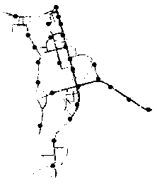
[0038] A method for laying out monitoring points of urban drainage network based on spatial data model, such as figure 1 ,include:
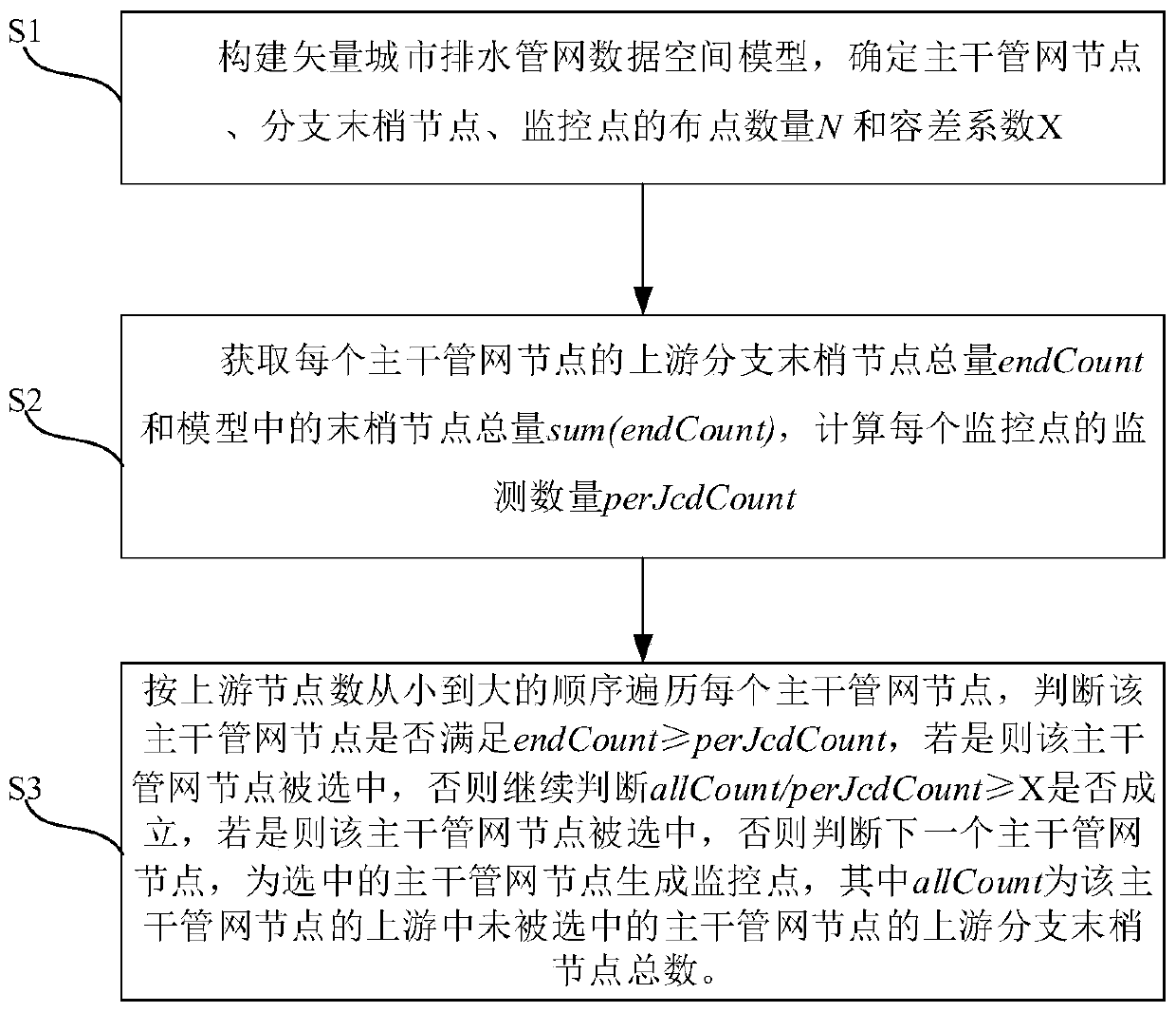
[0039] S1: Construct a vector urban drainage pipe network data space model, determine the number N of main pipe network nodes, branch end nodes, and monitoring points, and the optimal tolerance coefficient X. The optimal tolerance coefficient X described above is set according to experience;
[0040] S2: Obtain the total amount of upstream branch terminal nodes endCount of each main pipe network node and the total amount of terminal nodes sum(endCount) in the model, and calculate the monitoring quantity perJcdCount of each monitoring point. The calculation formula is:
[0041]
[0042] S3: Traverse each main pipe network node in ascending order of the number of upstream nodes, and judge whether the main pipe network node satisfies endCount≥perJcdCount, if so, the main pipe network node is selected, otherwise continue to judge Whether it is ...
Embodiment 2
[0045] The calculation process of the optimal tolerance coefficient X in this embodiment is:
[0046] Enumerate alternative tolerance coefficients X between 0 and 1 i , the enumeration scope is as follows:
[0047]
[0048] Each alternative tolerance factor X i Substituting into steps S1-S3 in the first embodiment, when the number of monitoring points finally selected in step S3 is equal to N or the closest to N, the corresponding X i Most reasonably, as the final X, the calculated X is substituted into steps S1-S3 in the first embodiment to select monitoring points.
[0049] All the other are the same as the first embodiment.
Embodiment 3
[0051] This embodiment proposes a spatial data model-based urban drainage pipe network monitoring point layout system corresponding to Embodiment 1, including:
[0052] Model construction module, used to construct vector urban drainage pipe network data space model;
[0053] The model analysis module is used to analyze the vector urban drainage pipe network data space model and determine the distribution number N and the optimal tolerance coefficient X of the main pipe network nodes, branch terminal nodes and monitoring points;
[0054] The monitoring design module is used to arrange monitoring points on the vector urban drainage pipe network data space model, and the specific process is as follows:
[0055] Traverse the main pipe network nodes in ascending order of the number of upstream nodes, obtain the total number of upstream branch end nodes endCount of each main pipe network node and the total amount of upstream end nodes sum(endCount) in the model, and calculate the su...
PUM
 Abstract
Description
Claims
Application Information
 - R&D
- Intellectual Property
- Life Sciences
- Materials
- Tech Scout
- Unparalleled Data Quality
- Higher Quality Content
- 60% Fewer Hallucinations
Browse by: Latest US Patents, China's latest patents, Technical Efficacy Thesaurus, Application Domain, Technology Topic, Popular Technical Reports.
© 2025 PatSnap. All rights reserved.Legal|Privacy policy|Modern Slavery Act Transparency Statement|Sitemap|About US| Contact US: help@patsnap.com