Engineering investigation data processing system

A data and client-side technology, applied in the field of engineering survey data processing system, can solve problems such as poor compatibility between high and low versions, high computer hardware requirements and overhead requirements, cumbersome software operations, etc., and achieve low software and computer performance requirements and facilitate inter-professional Deliver and realize the effect of unified management

Active Publication Date: 2020-06-12
SHANDONG TRAFFIC PLANNING DESIGN INST
View PDF0 Cites 3 Cited by
  • Summary
  • Abstract
  • Description
  • Claims
  • Application Information

AI Technical Summary

Problems solved by technology

[0003] The mainstream method of drawing out existing engineering survey drawings is to use CAD software such as Autocad to draw. CAD software such as AutoCAD must be installed to draw and edit drawings. It is necessary to purchase software before drawing and drawing, which is highly dependent on the intellectual property rights of CAD software. , and with the enrichment and expansion of functions, the basic platform CAD software installation package is getting bigger and bigger, the requirements for computer hardware and overhead are getting higher, and there is a problem of poor compatibility between high and low versions
Moreover, engineering survey software has high customization requirements for users of various units, and the cost of software use and secondary development and modification of survey programs is relatively high, resulting in many units preferring manual modification rather than program modification to the survey software being used
Although there are many softwares that support dwg files, the data interchangeability is poor. Many geotechnical analysis software such as Geoslope need to convert dwg to DXF before use
[0004] The degree of automatic drawing of engineering survey software needs to be improved. The operation of the software after data entry is relatively cumbersome, and user habits need to be cultivated to use it skillfully. Drawings such as profile diagrams, histograms, geotechnical tests, and in-situ tests need to be generated separately. The generation of reconnaissance reports requires a lot of manual intervention, and it is easy to miss when using geotechnical engineers who are not experienced enough
[0005] The engineering survey data management method is fragmented, the survey drilling data is out of touch with the laboratory test data, and there is a lack of effective verification support. The validity of the geotechnical parameters suggested in the survey report is not verified through the indoor geotechnical test data; the existing mainstream survey software data management The method is *.mdb and text data format, and it is often saved on a single machine. Once the data on the single machine is lost, the file cannot be recovered
At the same time, the information of the survey data is discrete, the data support and data verification are poor, and it is difficult to carry out effective collaborative application and transfer to the downstream professional

Method used


Image

  • Engineering investigation data processing system
  • Engineering investigation data processing system
  • Engineering investigation data processing system

Examples


Embodiment 1

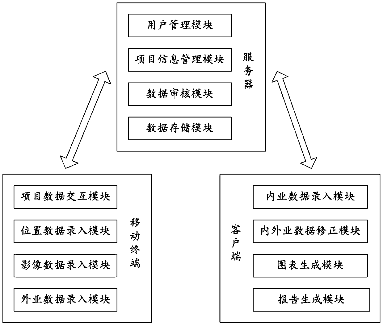
[0057] This embodiment discloses an engineering survey drawing system, such as figure 1 As shown, including mobile terminals, PC clients and servers.

[0058] Mobile terminals, including:

[0059]The project data interaction module obtains project information from the server. If it is a new project, a user with authority will create a new project and work site information for the user to choose. Ordinary users can select the current project and work site to be entered and determine the work scope information. , uploaded to the server after confirmation by the user;

[0060] The location data input module obtains the current location of the mobile terminal based on the positioning function of the mobile terminal, and uploads it to the server as the exploration point information after confirmation by the user;

[0061] The image data input module calls the image acquisition function to obtain the image data of the current exploration point and uploads it to the server;

[006...


PUM


Abstract

The invention discloses an engineering investigation data processing system, which comprises a client; the client comprises a chart generation module for calling data from a server, calling netDXF drawing to generate an electronic drawing, or calling an NPOI to generate a data table. Moreover, in the drawing process, the scale is generated in a self-adaptive mode according to the size of the drawing sheet and the size of the data, paging is automatically conducted according to the scale verified manually, the drawing efficiency is improved, and a very good auxiliary effect is achieved for engineers not rich enough in experience.

Description

technical field [0001] The invention belongs to the technical field of engineering survey, in particular to an engineering survey data processing system. Background technique [0002] The statements in this section merely provide background information related to the present disclosure and do not necessarily constitute prior art. [0003] The mainstream method of drawing out existing engineering survey drawings is to use CAD software such as Autocad to draw. CAD software such as AutoCAD must be installed to draw and edit drawings. It is necessary to purchase software before drawing and drawing, which is highly dependent on the intellectual property rights of CAD software. , and with the enrichment and expansion of functions, the CAD software installation package of the basic platform is getting bigger and bigger, and the requirements for computer hardware and overhead are getting higher, and there is also the problem of poor compatibility between high and low versions. More...

Claims


Application Information

Patent Timeline
Patent Type & Authority Applications(China)
IPC IPC(8): G06F30/12G06F111/02
CPCY02P90/30
Inventor 赵杰马文琪林志军林波李萌张鑫崔凯唐子文刘建国刘雪莹
Owner SHANDONG TRAFFIC PLANNING DESIGN INST
Why Eureka
Try Eureka