Method and system for recognizing cotton area in Xinjiang on basis of satellite image data

A technology for satellite imagery and area recognition, applied in scene recognition, cotton cultivation, character and pattern recognition, etc., can solve problems such as incomprehension, complexity, and difficulty in ensuring data accuracy, and achieve the effect of improving accuracy

Inactive Publication Date: 2020-06-30
武汉禾大科技有限公司
View PDF8 Cites 7 Cited by
  • Summary
  • Abstract
  • Description
  • Claims
  • Application Information

AI Technical Summary

Problems solved by technology

[0003] At present, the extraction of cotton spatial distribution information in the industry is mainly based on the decision tree classification method, but the existing cotton decision tree classification method is too complicated, using too many parameters, it is difficult to understand, and requires high knowledge of remote sensing and geosciences for classifiers. Leading to failure to promote and apply on a large scale
At the same time, it is difficult to obtain relevant data, and the accuracy of the data is difficult to guarantee
Part of the method process uses some empirical values, and a reasonable threshold cannot be set according to the regional characteristics. The accuracy of the result data is not high, which makes the recognition accuracy of the cotton area not high.

Method used


Image

  • Method and system for recognizing cotton area in Xinjiang on basis of satellite image data
  • Method and system for recognizing cotton area in Xinjiang on basis of satellite image data
  • Method and system for recognizing cotton area in Xinjiang on basis of satellite image data

Examples


Embodiment 1

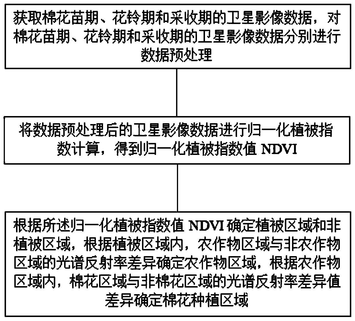
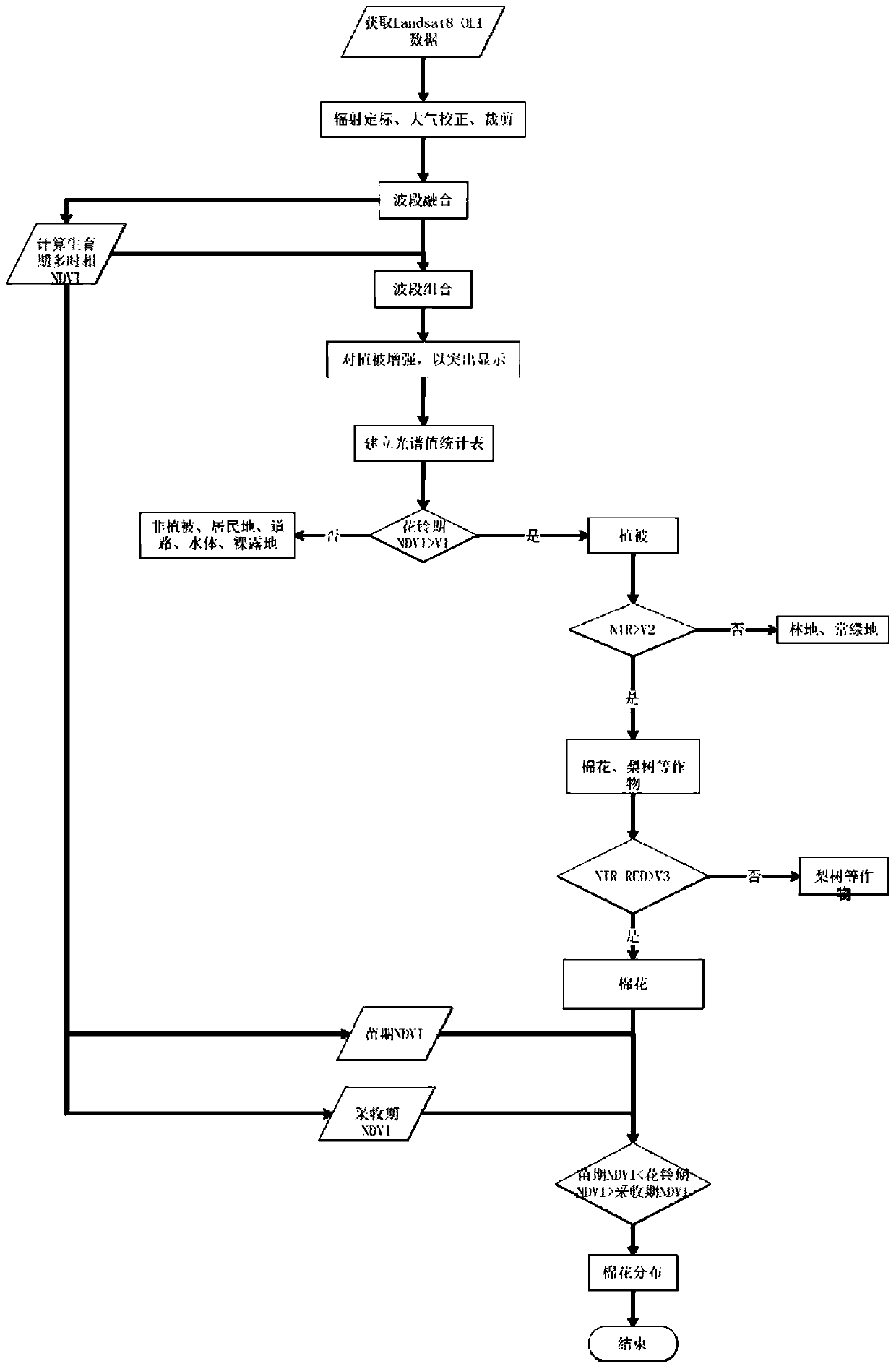
[0030] The embodiment of the present invention provides a method for identifying cotton regions in Xinjiang based on satellite image data, and its flow chart is as follows: figure 1 As shown, the method includes the following steps:

[0031] Obtain satellite image data of cotton seedling stage, flowering boll stage and harvesting stage, and perform data preprocessing on the satellite image data of cotton seedling stage, flowering boll stage and harvesting stage respectively;

[0032] Carry out the normalized difference vegetation index calculation on the satellite image data after data preprocessing, and obtain the normalized difference vegetation index value NDVI;

[0033] Determine the vegetation area and the non-vegetation area according to the normalized difference vegetation index value NDVI, determine the crop area according to the spectral reflectance difference between the crop area and the non-crop area in the vegetation area, and determine the crop area according to ...

Embodiment 2

[0054] An embodiment of the present invention provides a crop area identification system based on satellite image data, including a data acquisition module, a data preprocessing module, a normalized difference vegetation index value acquisition module, and a plant and cotton area acquisition module;

[0055] The data acquisition module is used to acquire satellite image data of cotton seedling stage, flowering boll stage and harvest stage;

[0056] The data preprocessing module is used to perform data preprocessing on the satellite image data of cotton seedling stage, flowering boll stage and harvest stage respectively;

[0057] The normalized difference vegetation index value acquisition module is used to calculate the normalized difference vegetation index value of the satellite image data after data preprocessing, and obtain the normalized difference vegetation index value NDVI;

[0058] The plant and cotton area acquisition module is used to determine the vegetation area a...


PUM


Abstract

The invention discloses a method and a system for recognizing a cotton area in Xinjiang on the basis of satellite image data, belonging to the technical field of remote-sensing crop classification andrecognition. The invention solves the problem of low recognition accuracy of the cotton area in the prior art. The method for recognizing the cotton area in Xinjiang on the basis of the satellite image data comprises the following steps: acquiring the satellite image data of a seedling stage, a flowering and boll setting stage and a harvesting period of cotton, and respectively performing data pre-processing on the satellite image data of the seedling stage, the flowering and boll setting stage and the harvesting period of the cotton; performing normalized differential vegetation index calculation on the processed satellite image data so as to obtain a normalized vegetation index value NDVI; determining a vegetation area and a non-vegetation area according to the normalized vegetation index value NDVI, determining a crop area according to the difference in spectral reflectance between the crop area and a non-crop area in the vegetation area, and determining a cotton planting area according to the difference in the spectral reflectance difference values between the cotton area and the non-cotton area in the crop area. The method provided by the invention the recognition accuracy ofthe cotton area.

Description

technical field [0001] The invention relates to the technical field of remote sensing crop classification and recognition, in particular to a Xinjiang cotton region recognition method and system based on satellite image data. Background technique [0002] Cotton is one of the main sources of economic income for farmers in the Xinjiang Uygur Autonomous Region, and it is the pillar industry of large-scale agriculture in our region. Timely and accurate acquisition of spatial distribution information of cotton in Xinjiang is of great importance for guiding agricultural production, rationally allocating resources, and solving safety problems in the cotton industry. significance. [0003] At present, the extraction of cotton spatial distribution information in the industry is mainly based on the decision tree classification method, but the existing cotton decision tree classification method is too complicated, using too many parameters, it is difficult to understand, and requires ...

Claims


Application Information

Patent Timeline
Patent Type & Authority Applications(China)
IPC IPC(8): A01G22/50A01G17/00G06K9/00
CPCA01G22/50A01G17/005G06V20/194G06V20/13
Inventor 刘世生王仁宗李叶民唐正尹新健
Owner 武汉禾大科技有限公司
Why Eureka
Try Eureka