

Method for monitoring and evaluating river by applying unmanned aerial vehicle surveying and mapping
A UAV and river technology, applied in unmanned aerial vehicles, surveying and navigation, water resource assessment, etc., can solve problems such as the inability to fully and accurately reflect the physical habitat of rivers, natural conditions, and human subjective factors.
- Summary
- Abstract
- Description
- Claims
- Application Information
AI Technical Summary
Problems solved by technology
Method used
Image

Examples
Embodiment 1
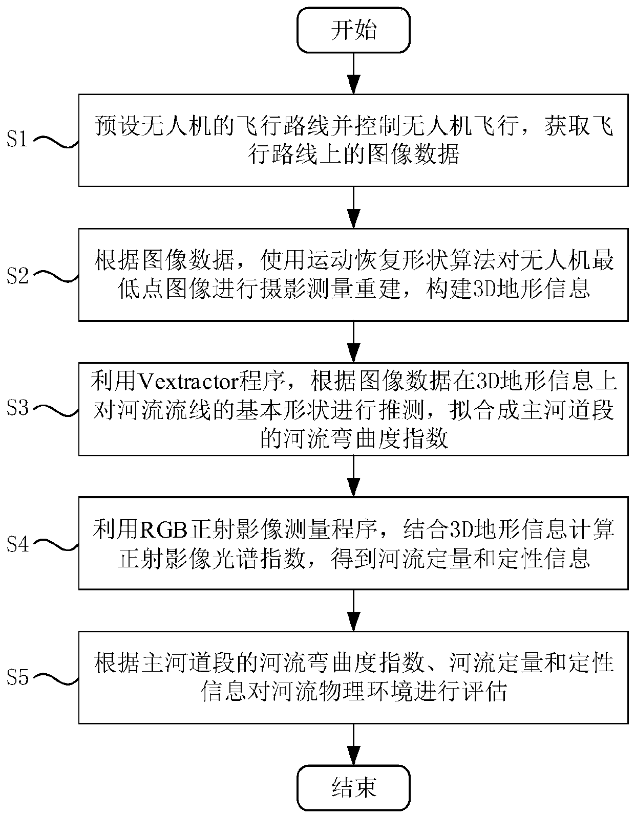
[0039] Such as figure 1 As shown, a method of monitoring and evaluating rivers using UAV surveying and mapping includes the following steps:
[0040] S1: Preset the flight route of the UAV and control the flight of the UAV, and obtain image data on the flight route;
[0041] S2: According to the image data, use the motion recovery shape algorithm to perform photogrammetric reconstruction of the UAV nadir image to construct 3D terrain information;
[0042] S3: Use the Vextractor program to estimate the basic shape of the streamline of the river based on the image data on the 3D terrain information, and fit it into the river tortuosity index of the main channel section;
[0043] S4: Using the RGB orthophoto measurement program, combined with 3D terrain information to calculate the orthophoto spectral index, to obtain the quantitative and qualitative information of the river;
[0044] S5: Assessment of the physical environment of the river based on the meandering index of the m...
Embodiment 2
[0063] More specifically, on the basis of Example 1, the study area of the Hostavicky Creek in Prague is a 1 km long urbanized area that underwent a complex restoration in 2015, assessing that the river is located on the northeast boundary of the Prague metropolitan area, in the old housing and the area between the new development zone. The stream was channelized during the construction of new road and highway infrastructure in the area in the 1980s. Thanks to the development of new residential areas, in 2015 the City of Prague realized a complex regional revitalization project aimed not only at restoring the meandering system of the river, but also at creating recreational infrastructure for the public, including cycle paths, playgrounds and parks. The complex of the entire restoration project includes grassy areas along the river banks and the planting of trees to stabilize the new pathways.
[0064] The monitoring design of the river restoration area of the present inv...
PUM
 Abstract
Description
Claims
Application Information